County of London
| byłe hrabstwo | |||
| 1889-1965 | |||
 | |||
| |||
| Państwo | |||
|---|---|---|---|
| Kraj | |||
| Populacja (1961) • liczba ludności |
| ||
| Plan | |||
 | |||
Położenie na mapie | |||
| Portal | |||
County of London – byłe hrabstwo w Anglii, istniejące w latach 1889-1965[1]. W 1961 roku hrabstwo liczyło 3 200 484 mieszkańców[2].
Podział administracyjny
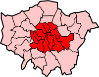
W skład hrabstwa wchodzi pięć dystryktów.
- City of London (nie metropolitan borough)
- Westminster
- Holborn
- Finsbury
- Shoreditch
- Bethnal Green
- Stepney
- Bermondsey
- Southwark
- Camberwell
- Deptford
- Lewisham
- Woolwich
- Greenwich
- Poplar
- Hackney
- Stoke Newington
- Islington
- St Pancras
- Hampstead
- St Marylebone
- Paddington
- Kensington
- Hammersmith
- Fulham
- Wandsworth
- Lambeth
- Battersea
- Chelsea
Przypisy
- ↑ zmiany (ang.). Vision of Britain. [dostęp 2016-03-01].
- ↑ liczba ludności (ang.). Vision of Britain. [dostęp 2016-03-01].
Media użyte na tej stronie
Flag of England. Saint George's cross (a red cross on a white background), used as the Flag of England, the Italian city of Genoa and various other places.
Autor: Mirrorme22, Licencja: CC BY-SA 4.0
Map of the Metropolitan Boroughs of the County of London in 1961. Numbers are those shown on File:LondonCounty.png by en:User:Morwen.
Autor:
- Map drawn by en:User:Morwen
Inner London (administrative).
Autor: Dr Greg, Mirrorme22, Licencja: CC BY-SA 3.0
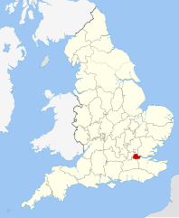
Map showing the County of London within England in 1889.


