Cumberland (rzeka)
 | |
| Kontynent | |
|---|---|
| Państwo | |
| Rzeka | |
| Długość | 1105[1] km |
| Powierzchnia zlewni | 46,8 tys.[1] km² |
| Źródło | |
| Miejsce | Hrabstwo Harlan, Kentucky |
| Wysokość | 353 m n.p.m. |
| Współrzędne | |
| Ujście | |
| Recypient | |
| Miejsce | Hrabstwo Livingston, Kentucky |
| Wysokość | 92 m n.p.m.[2] |
| Współrzędne | |
| Mapa | |
 | |
Cumberland (ang. Cumberland River) – rzeka w amerykańskich stanach Kentucky i Tennessee[2], dopływ rzeki Ohio.
Cumberland jest lewym dopływem Ohio; powstaje z połączenia rzek Poor Folk i Clover Folk, które wypływają z wyżyny Cumberland. Głównymi dopływami są rzeki Little, Red (prawe) oraz Big South Fork, Obey, Caney Fork, Harpeth (lewe)[1]. Na rzece znajdują się wodospady Cumberland Falls (objęte parkiem stanowym). Rzeka żeglowna około 740 km od zapory Wolf Creek[1].
Zobacz też
Przypisy
Media użyte na tej stronie
Autor: Uwe Dedering, Licencja: CC BY-SA 3.0
Relief location map of the USA (without Hawaii and Alaska).
EquiDistantConicProjection : Central parallel :
* N: 37.0° N
Central meridian :
* E: 96.0° W
Standard parallels:
* 1: 32.0° N
* 2: 42.0° N
Made with Natural Earth. Free vector and raster map data @ naturalearthdata.com.
Formulas for x and y:
x = 50.0 + 124.03149777329222 * ((1.9694462586094064-({{{2}}}* pi / 180))
      * sin(0.6010514667026994 * ({{{3}}} + 96) * pi / 180))
y = 50.0 + 1.6155950752393982 * 124.03149777329222 * 0.02613325650382181
      - 1.6155950752393982  * 124.03149777329222 *
     (1.3236744353715044  - (1.9694462586094064-({{{2}}}* pi / 180))
      * cos(0.6010514667026994 * ({{{3}}} + 96) * pi / 180))
The flag of Navassa Island is simply the United States flag. It does not have a "local" flag or "unofficial" flag; it is an uninhabited island. The version with a profile view was based on Flags of the World and as a fictional design has no status warranting a place on any Wiki. It was made up by a random person with no connection to the island, it has never flown on the island, and it has never received any sort of recognition or validation by any authority. The person quoted on that page has no authority to bestow a flag, "unofficial" or otherwise, on the island.
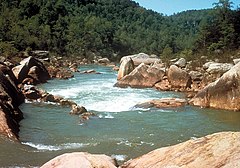
The Big South Fork of the Cumberland River in the Big South Fork National River and Recreation Area in Scott, Fentress, and Pickett Counties of Tennessee and McCreary County, Kentucky, USA.
Autor: Pfly, Licencja: CC BY-SA 2.5
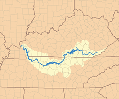
This is a map of the Cumberland River watershed. I, Pfly, made it, based on USGS data.


