Cumulonimbus
 Pośrodku, najwyższa – chmura kłębiasta deszczowa burzowa (Cumulonimbus capillatus), sąsiadujące z nią po prawej – chmura kłębiasta deszczowa (Cumulonimbus calvus), po lewej – chmury kłębiaste gatunku 'wypiętrzone' (Cumulus congestus), na prawo od tych wszystkich – chmury kłębiaste średnio wypiętrzone i pięknej pogody. Daleko po lewej widoczne następne kowadło | |
| Skrót nazwy | Cb |
|---|---|
| Symbol |
|
| Piętro | chmury o budowie pionowej |
| Gatunki | |
| Wysokość podstawy | od kilkuset m do 2–3 km |
| Wygląd | gruba, wypiętrzona chmura kłębiasta |
| Chmura opadowa | tak (chmura burzowa) |
| Grubość | do 18 km |
| Skład | mieszany |
| Zjawiska towarzyszące | praecipitatio, virga, pannus, incus, mamma, pileus, velum, arcus, murus, cauda, flumen, tuba |
Cumulonimbus (Cb, Charlie bravo[a]), chmura kłębiasta deszczowa – gęsta chmura rozbudowana pionowo na wysokość kilku lub kilkunastu kilometrów, niekiedy w kształcie wieży, o górnej powierzchni gładkiej, zakończonej kopulasto lub kalafiorowato (Cumulonimbus calvus, Cb cal) (calvus z łac. „łysy”), bądź w postaci bardziej rozbudowanej w piętrze wysokim (Cumulonimbus capillatus, Cb cap), przypominająca olbrzymie kowadło lub grzyb (incus – Cb cap inc). Podstawa chmur tego rodzaju znajduje się na wysokości 2–3 km, natomiast górny ich pułap w strefie międzyzwrotnikowej może przekraczać 20 km. Złożone w dolnej części z kropel wody, a w górnej z kryształków lodu (chmura mieszana) – są to chmury najbardziej rozbudowane w kierunku pionowym, dlatego zjawiska fizyczne w nich występujące są bardzo gwałtowne. Chmury tego rodzaju mogą być źródłem gwałtownych opadów deszczu, śniegu lub gradu, którym często towarzyszą wyładowania elektryczne (burze).
Cechą charakterystyczną tego rodzaju chmury jest występowanie silnego wiatru tuż przed rozpoczęciem opadu. Wiatr ten nosi nazwę szkwału i występuje w „przedniej części chmury”.
W chmurach tego typu występują bardzo silne prądy wznoszące (jak i zstępujące). Ich prędkość może dochodzić nawet do kilkudziesięciu metrów na sekundę. Spotykane prędkości prądów wznoszących dochodzą do 10–15 m/s, a nawet do 25 m/s (w przypadku, gdy chmura jest dobrze rozwinięta). Z tego powodu mogą się wydawać interesujące dla szybowników. Ze względu jednak na swój często burzowy, turbulentny charakter, wykorzystanie ich w lotach szybowcowych jest bardzo niebezpieczne. Dzięki swoim niezwykłym właściwościom, w przeszłości chmury te były wykorzystywane przez szybowników do zdobywania dużych wysokości, jednak w chwili obecnej loty szybowcowe w chmurach Cumulonimbus są w Polsce zakazane.

Chmura burzowa (Cumulonimbus capillatus), z kowadłem (incus) rozbudowanym poziomo

Chmury kłębiaste deszczowe (Cumulonimbus calvus) oraz chmury kłębiaste warstwowe soczewkowate (Stratocumulus lenticularis)
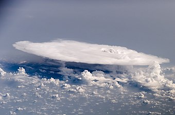
Cumulonimbus widziany z przestrzeni kosmicznej
Gatunki
Szczególne formy chmur kłębiastych deszczowych oraz zjawiska towarzyszące tym chmurom
- praecipitatio (pra) – opad atmosferyczny,
- virga – (vir) smuga opadu niedocierająca do powierzchni Ziemi,
- pannus (pan) – strzępy u podstawy chmury dającej opad,
- incus (inc) – kowadło burzowe (atrybut widocznej z daleka chmury burzowej),
- mamma (mam) – regularne drobne wybrzuszenia u podstawy chmury przypominające wymiona,
- pileus (pil) – soczewkowata chmura nad kopulastą powierzchnią chmury konwekcyjnej przypominająca czapeczkę,
- velum (vel) – zasłona,
- arcus (arc) – wał szkwałowy (pot. chmura szelfowa), chmurowy wał u podstawy zbliżającej się chmury kłębiastej deszczowej; jego przejściu towarzyszy szkwał,
- murus (mur) – chmura stropowa, obniżenie podstawy cumulonimbusa w strefie prądu wznoszącego,
- cauda (cau) – „ogon” chmury stropowej,
- flumen (flm) – pasmo chmur napływające do superkomórki,
- tuba (tub) – trąba powietrzna (lej kondensacyjny) lub wodna; zobacz tornado.
Uwagi
- ↑ Rozwinięcie skrótu Cb stosowane w lotniczej komunikacji radiowej.
| Wysokie |
|
|---|---|
| Średnie |
|
| Niskie |
|
| O budowie pionowej |
|

| Rodzaje | |||||||||
|---|---|---|---|---|---|---|---|---|---|
| Gatunki | |||||||||
| Odmiany | |||||||||
| |||||||||

Media użyte na tej stronie


Autor: MesserWoland, Licencja: CC-BY-SA-3.0
Cloud classification symbol CL9. Cumulonimbus, the upper part of which is clearly fibrous (cirriform) often in the form of an anvil; either accompanied or not by cumulonimbus without anvil or fibrous upper part, by cumulus, stratocumulus, stratus or 'scud' (Cumulonimbus cappillatus or incus).
Autor: Dwindrim (dyskusja · edycje), Licencja: CC BY-SA 1.0
This sky has "nice day" written all over it. The cumulus humilis indicates very little convection in the lower atmosphere, and the fact that it is well-formed indicates light winds at low levels. There is no cloud aloft, and thus no moisture or stable conditions or both. The cumulus congestus on the horizon suggests showers may be possible three or four hours from now, at the earliest, but chances are good it will remain a pleasant day through until the evening. The azure blue is typical of Alberta's clear, dust/haze/pollution-free skies.
Autor:
|


Cumulonimbus capillatus incus floating over Swifts Creek, Victoria in Australia.
.jpg)
Perhaps the most impressive of cloud formations, cumulonimbus (from the Latin for “pile” and “rain cloud”) clouds form due to vigorous convection (rising and overturning) of warm, moist, and unstable air. Surface air is warmed by the Sun-heated ground surface and rises; if sufficient atmospheric moisture is present, water droplets will condense as the air mass encounters cooler air at higher altitudes. The air mass itself also expands and cools as it rises due to decreasing atmospheric pressure, a process known as adiabatic cooling. This type of convection is common in tropical latitudes year-round and during the summer season at higher latitudes.
As water in the rising air mass condenses and changes from a gas to a liquid state, it releases energy to its surroundings, further heating the surrounding air and leading to more convection and rising of the cloud mass to higher altitudes. This leads to the characteristic vertical “towers” associated with cumulonimbus clouds, an excellent example of which is visible in this astronaut photograph. If enough moisture is present to condense and heat the cloud mass through several convective cycles, a tower can rise to altitudes of approximately 10 kilometers at high latitudes and to 20 kilometers in the tropics before encountering a region of the atmosphere known as the tropopause—the boundary between the troposphere and the stratosphere.
The tropopause is characterized by a strong temperature inversion. Beyond the tropopause, the air no longer gets colder as altitude increases. The tropopause halts further upward motion of the cloud mass. The cloud tops flatten and spread into an anvil shape, as illustrated by this astronaut photograph. The photo was taken from a viewpoint that was at an angle from the vertical, rather than looking straight down towards the Earth’s surface. The image, taken while the International Space Station was located over western Africa near the Senegal-Mali border, shows a fully formed anvil cloud with numerous smaller cumulonimbus towers rising near it. The high energy levels of these storm systems typically make them hazardous due to associated heavy precipitation, lightning, high wind speeds and possible tornadoes.