Cumulonimbus calvus
| ||
 Cumulonimbus calvus | ||
| Skrót nazwy | cal | |
| Symbol | ||
| Piętro | chmury o budowie pionowej | |
| Gatunki | Cumulonimbus calvus | |
| Wysokość podstawy | od kilkuset m do 2–3 km | |
| Wygląd | wysoko wypiętrzona chmura w kształcie kalafiora | |
| Chmura opadowa | tak | |
| Grubość | co najmniej kilka km | |
| Skład | mieszany | |
Cumulonimbus calvus (Cb cal) (łac. łysy) – gatunek chmury Cumulonimbus, w której górnej części przynajmniej pewne wypukłości zaczynają zatracać zarysy chmur kłębiastych, lecz nie wykazują jeszcze cech chmur pierzastych. Wypukłości i części pączkujące wykazują tendencję do utworzenia białawego masywu o mniej lub bardziej pionowym prążkowaniu. Chmury te mogą szybko rozbudowywać się do znacznych wysokości, co jest spowodowane przez silną energię konwekcji w nich występującą. Często przekształcają się wtedy w chmury Cumulonimbus capillatus.
Cumulonimbus calvus wywołują intensywne, konwekcyjne opady deszczu lub śniegu, szkwały, znacznie rzadziej grad. Rzadko dają wyładowania atmosferyczne.
Chmury te są niebezpieczne dla samolotów, głównie ze względu na turbulencje i opady, szczególnie gradu.
Symbol klucza CL=3![]() przewidziany dla Cumulonimbus calvus.
przewidziany dla Cumulonimbus calvus.
Galeria

Cumulonimbus calvus

Cumulonimbus calvus z widocznymi smugami opadowymi praecipitatio i tęczą
Cumulonimbus calvus z chmurą pileus widoczną nad jego wierzchołkiem

Wyładowanie atmosferyczne w chmurze Cumulonimbus calvus
Bibliografia
- Richard Hamblyn: Wielka księga chmur. Warszawa: Wydawnictwo RM, 2010, s. 30–31. ISBN 978-83-7243-808-9.
- Międzynarodowy Atlas Chmur, Państwowy Instytut Hydrologiczno-meteorologiczny, 1956
| Rodzaje | |||||||||
|---|---|---|---|---|---|---|---|---|---|
| Gatunki | |||||||||
| Odmiany | |||||||||
| |||||||||

Media użyte na tej stronie

Autor: Rui Glória, Licencja: CC BY-SA 4.0
This is a photography of a protected area of Portugal indexed in the World Database on Protected Areas with the ID:

Cloud symbol CL 3. Cumulonimbus, the summits of which, at least partially, lack sharp outlines but are neither clearly fibrous (cirriform) nor in the form of an anvil; cumulus, stratocumulus or stratus may also be present (cumulonimbus calvus).

Autor: Bidgee, Licencja: CC BY 3.0
Cumulonimbus cloud with Pileus in the Northern Territory.

Autor: Bidgee, Licencja: CC BY-SA 2.5
Early morning Cumulonimbus incus Northeast of Wagga Wagga, New South Wales, Australia
.jpg)
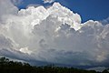
Autor: Tatters ✾ from Brisbane, Australia, Licencja: CC BY-SA 2.0
Storm season in Brisbane creates some spectacular sky.
DSC11053-H2Autor: Dwindrim (dyskusja · edycje), Licencja: CC BY-SA 1.0
This sky has "nice day" written all over it. The cumulus humilis indicates very little convection in the lower atmosphere, and the fact that it is well-formed indicates light winds at low levels. There is no cloud aloft, and thus no moisture or stable conditions or both. The cumulus congestus on the horizon suggests showers may be possible three or four hours from now, at the earliest, but chances are good it will remain a pleasant day through until the evening. The azure blue is typical of Alberta's clear, dust/haze/pollution-free skies.
Autor: Cette photo a été prise par Brigitte ALLIOT., Licencja: CC0
Cumulus de forme boursouflée