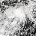
Cyklon Agatha
| ||
| Burza tropikalna w skali Saffira-Simpsona | ||
Komórka cyklonu | ||
| Typ | Cyklon | |
|---|---|---|
| Początek | 29 maja 2010 | |
| Koniec | 30 maja 2010 | |
| Najwyższa prędkość wiatru | 70 km/h | |
| Ofiary śmiertelne | 204 osoby | |
| Dotknięte kraje | Gwatemala, Salwador, Honduras, Meksyk, Nikaragua | |
 Trasa przejścia Agathy | ||
Cyklon Agatha - tropikalny cyklon, który przeszedł nad centralną Ameryką w maju 2010.
Główną przyczyną tylu ofiar śmiertelnych nie był wiatr, a obficie padające deszcze. W stolicy Gwatemali, Gwatemali, w centrum miasta powstał co najmniej 10-metrowej głębokości krater, pochłaniając budynki mieszkalne.
Ofiary
| Kraj | Ofiary śmiertelne |
|---|---|
| 174 | |
| 18 | |
| 11 | |
| 1 | |
| Razem | 204 |
Media użyte na tej stronie
Tropical Storm Agatha of the 2010 Pacific hurricane season on May 29, 2010 soon after being upgraded to a tropical storm.
Track map of Tropical Storm Agatha of the 2010 Pacific hurricane season. The points show the location of the storm at 6-hour intervals. The colour represents the storm's maximum sustained wind speeds as classified in the Saffir–Simpson scale (see below), and the shape of the data points represent the nature of the storm, according to the legend below.
Storm type


