DW Stadium
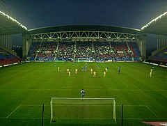
 Mecz Wigan Athletic – Gillingham w roku 2004 widziany z południowej trybuny | |
| Państwo | |
|---|---|
| Kraj | |
| Adres | Robin Park Wigan WN5 0UH |
| Koszt budowy | 30 000 000 funtów |
| Data otwarcia | |
| Klub | Wigan Athletic (1999-) |
| Pojemność stadionu | 25 138 |
| Rekordowa frekwencja | 25 023, |
| Wymiary boiska | 105 x 68m |
| Nawierzchnia boiska | trawa |
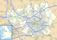
Położenie na mapie Wielkiego Manchesteru Contains Ordnance Survey data © Crown copyright and database right, CC BY-SA 3.0 | |
Położenie na mapie Wielkiej Brytanii (c) Karte: NordNordWest, Lizenz: Creative Commons by-sa-3.0 de | |
| Strona internetowa | |
DW Stadium – stadion sportowy, położony w mieście Wigan, w Wielkiej Brytanii. Oddany został do użytku w 1999 roku. Od tego czasu swoje mecze na tym obiekcie rozgrywa zespół Championship Wigan Athletic F.C. Jego pojemność wynosi 25 138 miejsc. Rekordową frekwencję, wynoszącą 25 023 osób, odnotowano w 2006 roku podczas meczu ligowego pomiędzy Wigan a Liverpoolem.
Linki zewnętrzne
- DW Stadium. stadiumguide.com. [dostęp 2020-12-01]. (ang.).
Media użyte na tej stronie
(c) Karte: NordNordWest, Lizenz: Creative Commons by-sa-3.0 de
Location map of the United Kingdom
Flag of England. Saint George's cross (a red cross on a white background), used as the Flag of England, the Italian city of Genoa and various other places.
Autor:
- Gfi-set01-stadium.png: gfi
- derivative work: Frédéric (talk)
icone pour terrain de sport
Autor: Hindleyite (talk) from the English Wikipedia, Licencja: CC BY-SA 3.0
A view of the JJB Stadium before the second half kicks off in a game between Wigan Athletic and Gillingham.
Contains Ordnance Survey data © Crown copyright and database right, CC BY-SA 3.0
Map of Greater Manchester, UK with the following information shown:
- Administrative borders
- Coastline, lakes and rivers
- Roads and railways
- Urban areas
The data includes both primary routes and railway lines.
Equirectangular map projection on WGS 84 datum, with N/S stretched 165%
Geographic limits:
- West: 2.80W
- East: 1.90W
- North: 53.70N
- South: 53.32N


