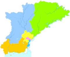
Dandong
| |||||||||||
 | |||||||||||
| Państwo | |||||||||||
|---|---|---|---|---|---|---|---|---|---|---|---|
| Prowincja | Liaoning | ||||||||||
| Powierzchnia | prefektura[1]: 14 981 km² | ||||||||||
| Wysokość | 8 m n.p.m. | ||||||||||
| Populacja (2017[2]) • liczba ludności | 659 400 | ||||||||||
| Nr kierunkowy | 0415 | ||||||||||
| Kod pocztowy | 118000 | ||||||||||
| Tablice rejestracyjne | 辽F | ||||||||||
| Strefa czasowa | UTC+8:00 | ||||||||||
 | |||||||||||
| Strona internetowa | |||||||||||
| Portal | |||||||||||
Dandong (chiń. upr. 丹东; pinyin Dāndōng) – miasto o statusie prefektury miejskiej w północno-wschodnich Chinach, w prowincji Liaoning, port morski i śródlądowy nad rzeką Yalu Jiang, w pobliżu jej ujścia do Morza Żółtego, na granicy z Koreą Północną.
W 2010 roku liczba mieszkańców miasta wynosiła 673 737[3]. Prefektura miejska w 1999 roku liczyła 2 405 302 mieszkańców[4]. Ośrodek przemysłu drzewnego, jedwabniczego, chemicznego, papierniczego i metalurgicznego[5].
Do 1964 roku miasto nosiło nazwę Andong (chiń. trad. 安東).
Miasta partnerskie
Przypisy
- ↑ 中国丹东-丹东概貌导航-自然地理 [zarchiwizowane z adresu 2011-07-24] (chiń.).
- ↑ China Urban Construction Statistical Yearbook 2017, Beijing: China Statistics Press, s. 50 [dostęp 2020-01-27] [zarchiwizowane z adresu 2019-06-18].
- ↑ Dandong (ang.). World Gazetteer. [dostęp 2010-12-22].
- ↑ China Prefectures (ang.). Statoids. [dostęp 2010-12-22].
- ↑ Dandong, [w:] Encyklopedia PWN [online] [dostęp 2010-12-22].
Media użyte na tej stronie
Autor: Uwe Dedering, Licencja: CC BY-SA 3.0
Location map of China.
EquiDistantConicProjection : Central parallel :
- N: 36.0° N
Central meridian :
- E: 104.0° E
Standard parallels:
- 1: 30.0° N
- 2: 42.0° N
Latitudes on the central meridian :
- top: 57.0° E
- center: 37° 29′ N
- bottom: 17.96° N
The flag of Navassa Island is simply the United States flag. It does not have a "local" flag or "unofficial" flag; it is an uninhabited island. The version with a profile view was based on Flags of the World and as a fictional design has no status warranting a place on any Wiki. It was made up by a random person with no connection to the island, it has never flown on the island, and it has never received any sort of recognition or validation by any authority. The person quoted on that page has no authority to bestow a flag, "unofficial" or otherwise, on the island.
Autor: Chk2011, Licencja: CC BY-SA 4.0
administrative divisions of Dandong City, Liaoning, China
Autor: Das steinerne Herz, Licencja: CC BY-SA 3.0
Location map of Liaoning, People's Republic of China
Equirectangular projection, N/S stretching 141 %. True scale parallel: 45°00' N. Geographic limits of the map:
- N: 44.0° N
- S: 38.5° N
- W: 118.5° E
- E: 126.0° E


