Daventry (dystrykt)
| dystrykt niemetropolitalny | |
(c) Mark Hobbs, CC BY-SA 2.0 Daventry | |
| Państwo | |
|---|---|
| Kraj | |
| Region | East Midlands |
| Hrabstwo | Northamptonshire |
| Siedziba | Daventry |
| Powierzchnia | 662,6 km² |
| Populacja (2011) • liczba ludności | 77 843 |
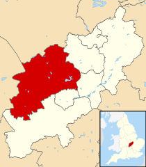
| Położenie na mapie Northamptonshire Contains Ordnance Survey data © Crown copyright and database right, CC BY-SA 3.0 | |
| Strona internetowa | |
| Portal | |
Daventry – dystrykt w hrabstwie Northamptonshire w Anglii. W 2011 roku dystrykt liczył 77 843 mieszkańców[1].
Miasta
Inne miejscowości
Arthingworth, Ashby St Ledgers, Badby, Barby Nortoft, Barby, Boughton, Braunston, Brington, Brixworth, Brockhall, Byfield, Canons Ashby, Catesby, Chapel Brampton, Charwelton, Church Brampton, Church Brampton with Chapel Brampton, Church Stowe, Clay Coton, Clipston, Cold Ashby, Coton, Cottesbrooke, Creaton, Crick, Dodford, Draughton, Drayton, East Farndon, East Haddon, Everdon, Farthingstone, Fawsley, Flore, Great Brington, Great Oxendon, Guilsborough, Hanging Houghton, Hannington, Harlestone, Haselbech, Hellidon, Hinton, Holcot, Holdenby, Hollowell, Kelmarsh, Kilsby, Lamport, Lilbourne, Little Brington, Little Everdon, Long Buckby, Lower Catesby, Maidwell, Marston Trussell, Moulton, Murcott, Muscott, Naseby, Newnham, Nobottle, Nortoft, Norton, Old, Overstone, Pitsford, Preston Capes, Ravensthorpe, Scaldwell, Sibbertoft, Spratton, Stanford on Avon, Staverton, Sulby, Teeton, Thornby, Upper Catesby, Upper Stowe, Walgrave, Watford, Weedon Bec, Welford, Welton, West Farndon, West Haddon, Westhorp, Whilton, Winwick, Woodford Halse, Yelvertoft.
Przypisy
- ↑ Area: Daventry (Local Authority) (ang.). Neighbourhood Statistics (ONS). [dostęp 2016-04-29]. [zarchiwizowane z tego adresu (2016-10-06)].
Media użyte na tej stronie
Flag of England. Saint George's cross (a red cross on a white background), used as the Flag of England, the Italian city of Genoa and various other places.
Contains Ordnance Survey data © Crown copyright and database right, CC BY-SA 3.0
Map of Northamptonshire, UK with Daventry highlighted.
Equirectangular map projection on WGS 84 datum, with N/S stretched 160%(c) Mark Hobbs, CC BY-SA 2.0
The Coach and Horses Inn, Daventry, Northamptonshire The Coach and Horses is in Warwick street in the town of Daventry. its is one of the old caoching houses of the town which happily is still a public house.


