Dean Prior
| ||
(c) Adrian Platt, CC BY-SA 2.0 | ||
| Państwo | ||
| Kraj | ||
| Hrabstwo | Devon | |
| Dystrykt | South Hams | |
| Populacja (2011) • liczba ludności | 201 | |
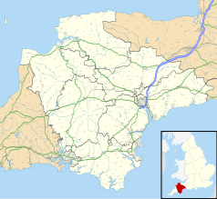
Położenie na mapie Devonu Contains Ordnance Survey data © Crown copyright and database right, CC BY-SA 3.0 | ||
Położenie na mapie Wielkiej Brytanii (c) Karte: NordNordWest, Lizenz: Creative Commons by-sa-3.0 de | ||
| 50,45°N 3,78°W/50,450000 -3,783330 | ||
| Portal | ||
Dean Prior – wieś i civil parish w Anglii, w Devon, w dystrykcie South Hams. W 2011 civil parish liczyła 201 mieszkańców[1]. Dean Prior jest wspomniana w Domesday Book (1086) jako Dene/Dena[2].
Przypisy
- ↑ Local statistics - Office for National Statistics, www.neighbourhood.statistics.gov.uk [dostęp 2017-11-17] (ang.).
- ↑ The Domesday Book Online - Devonshire C-D, www.domesdaybook.co.uk [dostęp 2017-11-17].
Linki zewnętrzne
Media użyte na tej stronie
(c) Karte: NordNordWest, Lizenz: Creative Commons by-sa-3.0 de
Location map of the United Kingdom
Flag of England. Saint George's cross (a red cross on a white background), used as the Flag of England, the Italian city of Genoa and various other places.
(c) Adrian Platt, CC BY-SA 2.0
Dean Prior Church. This C14th church is dedicated to St George the Martyr, and the parish stretches westwards out into the centre of Dartmoor. It is situated right on the side of the busy A38 Exeter to Plymouth dual carriageway, the barriers of the central reservation can be seen in the foreground, and despite the busy noisy road (the image was taken between vehicles) has services every week. Even the crows cope with the noise! See also 1097695 and 1097728 and church website http://www.deanpriorchurch.co.uk .
Contains Ordnance Survey data © Crown copyright and database right, CC BY-SA 3.0
Map of Devon, UK with the following information shown:
- Administrative borders
- Coastline, lakes and rivers
- Motorways and primary routes
- Urban areas
Equirectangular map projection on WGS 84 datum, with N/S stretched 150%
Geographic limits:
- West: 4.72W
- East: 2.86W
- North: 51.3N
- South: 50.16N


