Delaware (rzeka)
 | |
| Kontynent | |
|---|---|
| Państwo | |
| Rzeka | |
| Długość | 580 km |
| Powierzchnia zlewni | 34 963 km² |
| Średni przepływ | |
| Źródło | |
| Miejsce | góry Catskill, Mount Jefferson, hrabstwo Schoharie |
| Wysokość | 883[2] |
| Współrzędne | |
| Ujście | |
| Recypient | |
| Miejsce | Zatoka Delaware |
| Wysokość | 0 |
| Współrzędne | |
| Mapa | |
 | |
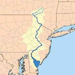
Delaware (ang Delaware River) – rzeka na północnym wschodzie Stanów Zjednoczonych.
Rzeka wypływa z gór Catskill i kierując się na południe, wpada szerokim, lejkowatym ujściem do Atlantyku. Estuarium zaczyna się w okolicy Trenton i ma długość około 240 km, kończąc się ujściem pomiędzy przylądkami May (północny) i Henlopen (południowy). W dolnej, najszerszej części estuarium nosi nazwę Zatoki Delaware (ang. Delaware Bay)[3]. Długość całej rzeki wynosi 580 km. Dorzecze obejmuje około 35 tys. km², i żyje w nim około 7,3 mln ludzi, natomiast rzeka jest źródłem wody dla ponad 15 mln. Rzeka przepływa przez cztery stany Nowy Jork, Pensylwania, New Jersey i Delaware[4]
Główny dopływ rzeki to Lackawaxen River, a jednym z pozostałych jest Abe Lord Creek.
Zobacz też
Przypisy
- ↑ Delaware River at Trenton NJ, Current Conditions for New Jersey: Streamflow (ang.). National Water Information System, U.S. Geological Survey. [dostęp 2014-12-07].
- ↑ Feature Detail Report for: West Branch Delaware River (ang.). National Water Information System, U.S. Geological Survey. [dostęp 2014-12-07].
- ↑ Delaware River Facts, The Estuary (ang.). Delaware Riverkeeper Network. [dostęp 2014-12-07]. [zarchiwizowane z tego adresu (2010-07-13)].
- ↑ Delaware River Basin (ang.). National Water Census, U.S. Geological Survey. [dostęp 2014-12-07].
Media użyte na tej stronie
The flag of Navassa Island is simply the United States flag. It does not have a "local" flag or "unofficial" flag; it is an uninhabited island. The version with a profile view was based on Flags of the World and as a fictional design has no status warranting a place on any Wiki. It was made up by a random person with no connection to the island, it has never flown on the island, and it has never received any sort of recognition or validation by any authority. The person quoted on that page has no authority to bestow a flag, "unofficial" or otherwise, on the island.
Autor: User:Mwanner, Licencja: CC-BY-SA-3.0
Delaware River near Worthington State Park
Autor: Autor nie został podany w rozpoznawalny automatycznie sposób. Założono, że to Kmusser (w oparciu o szablon praw autorskich)., Licencja: CC BY-SA 2.5
This is a map of the Delaware River Watershed. I, Karl Musser, created it based on USGS data.
Autor: Uwe Dedering, Licencja: CC BY-SA 3.0
Relief location map of the USA (without Hawaii and Alaska).
EquiDistantConicProjection : Central parallel :
* N: 37.0° N
Central meridian :
* E: 96.0° W
Standard parallels:
* 1: 32.0° N
* 2: 42.0° N
Made with Natural Earth. Free vector and raster map data @ naturalearthdata.com.
Formulas for x and y:
x = 50.0 + 124.03149777329222 * ((1.9694462586094064-({{{2}}}* pi / 180))
      * sin(0.6010514667026994 * ({{{3}}} + 96) * pi / 180))
y = 50.0 + 1.6155950752393982 * 124.03149777329222 * 0.02613325650382181
      - 1.6155950752393982  * 124.03149777329222 *
     (1.3236744353715044  - (1.9694462586094064-({{{2}}}* pi / 180))
      * cos(0.6010514667026994 * ({{{3}}} + 96) * pi / 180))


