Demawend
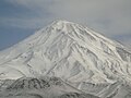
 Widok na Demawend | |
| Państwo | |
|---|---|
| Położenie | prefektura Amol↗ |
| Pasmo | |
| Wysokość | 5610 m n.p.m. |
| Wybitność | 4667 m |
| Pierwsze wejście | 905 |
Położenie na mapie Iranu  | |
Demawend (5610 m n.p.m.) – wulkan drzemiący w górach Elburs, najwyższy szczyt Iranu, położony około 70 km na północny wschód od Teheranu i ok. 60 km na południe od miasta Amol. Wulkan zbudowany głównie z kwasowych law andezytowych. Duży kąt nachylenia stoków (stratowulkan) - ok. 30-40°. U podnóża występują licznie wody siarczanowe. Wysokość wulkanu wynosi 5610 m. Starsze pomiary wskazywały na 5671 m, jest to jednak wartość zawyżona.

Historia zdobywania szczytu
Pierwszego udokumentowanego wejścia na szczyt dokonał Abu Dolaf Kazradżi w 905 r.[1] Trzysta lat później Jakut Ibn Abdallah al-Hamawi - greckiego pochodzenia geograf w służbie imperium bizantyjskiego, próbował ponownie zdobyć Demawend, lecz musiał zawrócić tuż spod wierzchołka. Tym niemniej, jego miejscowi przewodnicy, którzy - jak z tego wynika - bywali już na szczycie góry, opisali mu go na tyle dokładnie, że podróżnik umieścił ten opis (zgodny z realiami) w swym słynnym Słowniku krajów (Mu'dżam al-Buldan).
Demawend, który przy dobrej pogodzie widoczny jest z Teheranu, nie należy do szczytów trudnych do wspinaczki. Nie stromość skał, ale wysokość, wulkaniczne podłoże i zmieniające się często warunki pogodowe, odstraszały kolejnych, potencjalnych zdobywców.[2] Jeszcze na początku XIX w. kwestionowano w ogóle możliwość zdobycia tej góry. Pierwsze wejście na szczyt Demawendu dokonane przez Europejczyka miało być może miejsce w 1837 r. Miał go dokonać W. Taylor Thompson, topograf i sekretarz angielskiego poselstwa w Teheranie. Część historyków alpinizmu uważa je jednak za wątpliwe[3], przyjmując, że Thompson nie dotarł na sam szczyt, lecz zawrócił ok. 300 m pod wierzchołkiem[4]. Szczytu nie osiągnął również francuski botanik Pierre Martin Rémi Aucher-Éloy (1792-1838), któremu przypisywano drugie wejście[4]. W tej sytuacji jest możliwe, że 1 sierpnia 1843 r. jako pierwszy Europejczyk zdobył Demawend Theodor Kotschy - austriacki botanik i podróżnik, urodzony w Ustroniu na Śląsku Cieszyńskim[4]. Kolejnego znanego wejścia dokonał samotnie 28 sierpnia 1852 r. Józef Czarnota - urodzony w Strumieniu na Śląsku Cieszyńskim polski poddany cesarza austriackiego i dyrektor górniczy w służbie szacha perskiego[5]. Poczynając od roku 1860 rejestrowane są coraz liczniejsze wyprawy na Demawend, organizowane początkowo przez Brytyjczyków i Niemców.

Mitologia
Mityczne miejsce uwięzienia Aži Dahaka przez Feriduna.
Zobacz też
Przypisy
- ↑ Damavand. SummitPost.org.
- ↑ Ryszard Badowski, Demawend, Onet.pl [zarchiwizowane z adresu 2010-04-12].
- ↑ Szczepański Jan Alfred: Polskie wyprawy egzotyczne, w: "W skałach i lodach świata", t. 2 pt. "Polskie wyprawy egzotyczne", Wiedza Powszechna, Warszawa 1961, s. 22-23
- ↑ a b c Saduś Lucjan: Demawend, w: “Wiechy” R. 36 (1967), wyd. Państwowe Wydawnictwo Naukowe, Kraków 1968, s. 60-66;
- ↑ Golec Józef, Bojda Stefania: Czarnota Józef (1818-1852), w: Słownik biograficzny Ziemi Cieszyńskiej t. 2, wyd. pierwsze, Cieszyn 1995, s. 40-41 ISBN 83-901-007-07
Linki zewnętrzne
 (c) Alireza Javaheri, CC BY 3.0
 (c) Alireza Javaheri, CC BY 3.0
 (c) Alireza Javaheri, CC BY 3.0
 (c) Alireza Javaheri, CC BY 3.0
 (c) Alireza Javaheri, CC BY 3.0
 (c) Alireza Javaheri, CC BY 3.0
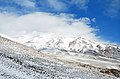 (c) Alireza Javaheri, CC BY 3.0
 (c) Alireza Javaheri, CC BY 3.0
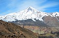 (c) Alireza Javaheri, CC BY 3.0
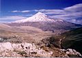 (c) Alireza Javaheri, CC BY 3.0
 (c) Alireza Javaheri, CC BY 3.0
 (c) Alireza Javaheri, CC BY 3.0


Media użyte na tej stronie


Black up-pointing triangle ▲, U+25B2 from Unicode-Block Geometric Shapes (25A0–25FF)

(c) Alireza Javaheri, CC BY 3.0
Iran - Damavand view from Amiri


Autor: Uwe Dedering, Licencja: CC BY-SA 3.0
Topographic map of the Iranian plateau in Central Asia, connecting to Anatolia in the west and Hindu Kush and Himalaya in the east.
Autor: M samadi, Licencja: CC BY 3.0
East View of the Mount Damavand in October

(c) Alireza Javaheri, CC BY 3.0
Iran - Tehran - Damavand view
_-_Information_in_Page_2_-_panoramio.jpg)
(c) Alireza Javaheri, CC BY 3.0
Damavand mountain from Rineh Iran (5671) - Information in Page 2
Mount Damāvand (Persian: دماوند ) also known as Donbavand, a potentially active volcano and the highest peak in Iran, has a special place in Persian mythology and folklore. Located in the middle Alborz Range, adjacent to Varārū, Sesang, Gol-e Zard and Mīānrūd, it is the highest point in the Middle East and the highest volcano in all of Asia. It is a potentially active volcano,since there are fumaroles near the summit crater emitting sulfur, which were known to be active on July 6, 2007. The mountain is located near the southern coast of the Caspian Sea, in Āmol county, Māzandarān, 66 kilometres (41 miles) northeast of Tehran. Contents Symbolism and mythology Damavand is, as any cursory reading of Persian literature will indicate, the Mount Olympus of Persian mythology. Damāvand is the symbol of Iranian resistance against despotism and foreign rule in Persian poetry and literature. In Zoroastrian texts and mythology, the three-headed dragon Aži Dahāka was chained within Mount Damāvand, there to remain until the end of the world. In a later version of the same legend, the tyrant Zahhāk was also chained in a cave somewhere in Mount Damāvand after being defeated by Kāveh and Fereydūn. Persian poet Ferdowsi depicts this event in his masterpiece, the Shahnameh: بیاورد ضحاک را چون نوند به کوه دماوند کردش ببند The mountain is said to hold magical powers in the Shahnameh. Damāvand has also been named in the Iranian legend of Arash as the location he fired his arrow to mark the Iran border. The famous poem Damāvand by Mohammad Taqī Bahār is also one fine example of the mountain's significance in Persian literature. The first verse of this poem reads: ای دیو سپید پای در بند Ay dīve sepīde pāī dar band, Oh white demon with feet in chains ای گنبد گیتی، ای دماوند Ay gonbade gītī, ay Damāvand Oh terrestrial dome, Oh Mount Damāvand Mount Damavand is depicted on the reverse of the Iranian 10,000 rials banknote. [edit] Thermal springs A fumarole near the summit of Damavand, emitting sulfur Mt Damavand has some thermal springs (Abe Garm Larijan) with therapeutic qualities. These mineral hot springs are mainly located on the volcano's flanks and at the base, giving evidence of volcanic heat comparatively near the surface of the earth. While no historic eruptions have been recorded, hot springs at the base and on the flanks, and fumaroles and solfatara near the summit, indicate a hot or cooling magma body still present beneath the volcano, so that Damavand is a potentially active volcano. The most important of these hot springs are located in Abe Garm Larijan in a village by the name Larijan in the district of Larijan in Lar Valley . The water from this spring is useful in the treatment of chronic wounds and skin diseases. Near these springs there are public baths with small pools for public use. Routes to the summit Damavand volcanic crater in August The best major settlement for mountain climbers is the new Iranian Mountain Federation Camp in Polour village, located on the south of the mountain. There are at least 16 known routes[8] to the summit which have different difficulties. Some of them are very dangerous and require rock climbing. The most popular route is the Southern Route which has step stamps and also a camp midway called Bargah Sevom Camp/Shelter[9] at 4220 m (about 13,845 ft). The longest route is the Northeastern and it takes two whole days to reach the summit starting from downhill village of Nāndal and a night stay at Takht-e Fereydoun (elevation 4300 m - about 13,000 ft), a two-story shelter. The western route is famous for its sunset view. Sīmorgh shelter in this route at 4100 m (about 13,500 ft) is a newly constructed shelter with two stories. There is a frozen waterfall/Icefall (Persian name Ābshār Yakhī)about 12m tall and the elevation of 5100m is the highest fall in Iran and Middle East.
کوه دَماوَند کوهی در شمال ایران است که به عنوان بلندترین کوه این کشور و بلندترین آتشفشان خاورمیانه[۱] شناخته میشود. این کوه در قسمت مرکزی رشتهکوه البرز در جنوب دریای خزر و در بخش لاریجان شهرستان آمل قرار دارد. قله دماوند که از نظر تقسیمات کشوری در استان مازندران قرار دارد،[۶] به هنگام صاف و آفتابی بودن هوا، از شهرهای تهران، ورامین و قم و همچنین کرانههای دریای خزر قابل رؤیت است. نزدیکترین شهر بزرگ به این کوه لاریجان است. کوه دماوند در سیام تیرماه سال ۱۳۸۷ به عنوان نخستین اثر طبيعی ايران در فهرست آثار ملی ایران ثبت شد. از دماوند در اساطیر ایران هم یاد شده است و شهرتش بیش از هرچیز به این سبب است که ضحاک (پادشاهی ستمگر و اژدهافش) در آن به بند کشیده شدهاست. در آثار ادبی فارسی نیز فراوان به این اسطوره و به طور کلیتر کوه دماوند اشاره شدهاست. دماوند دارای چشمههای آب گرم لاریجان، اسک و وانه است. ارتفاع منابع مختلف اندازههای گوناگونی برای ارتفاع قلهٔ دماوند از سطح دریا ذکر کردهاند. به نقل از درگاه ملی آمار ایران، ارتفاع این قله ۵٬۶۱۰ متر است ؛ منابع دیگر، از جمله پایگاه ملی دادههای علوم زمین ایران و وبگاه رصدخانهٔ زمین ناسا، ارتفاع ۵٬۶۷۰ متر و ۵٬۶۷۱ متر را نیز برای قلهٔ این کوه ذکر کردهاند. دایرةالمعارف فارسی فهرستی شش موردی از ارتفاعهایی که برای این قله آمدهاست ذکر میکند که از ۵٬۵۴۳ تا ۶٬۴۰۰ متر میرسد. ارتفاع نسبی دماوند، که با اندازهگیری ارتفاع قله نسبت به پستترین دره بین این قله و نزدیکترین قلّه مرتفعتر تعیین میشود، ۴۶۶۱ متر است که دماوند را در ردهٔ دوازدهم بلندترین قلههای دنیا از نظر ارتفاع نسبی قرار میدهد. فاصله از شهرهای نزدیک این قله در ۶۹ کیلومتری شمال شرقی تهران، ۶۲ کیلومتری غرب آمل و ۲۶ کیلومتری شمال شهر دماوند واقع شدهاست. رودخانههای پیرامون رودخانه تینه در شمال، رودخانه هراز در جنوب و شرق و رودخانه دلیچای در غرب این کوه واقع شدهاند. کوهستان قله دماوند در شرق کوهستان البرز مرکزی (استان مازندران) از رشته کوه البرز قرار دارد. قلههای مجاور آن ورارو، سه سنگ، گل زرد، کاعون(کبود) و میانرود است. دما حداقل دمای هوا در ارتفاعات دماوند تا ۶۰ درجه زیرصفر (در زمستان) و تا یکی-دو درجه زیر صفر (در تابستان) پایین میآید. باد سرعت توفان در دماوند گاهی از ۱۵۰ کیلومتر در ساعت میگذرد. سرعت باد در کوهپایهها گاه به هفتاد کیلومتر در ساعت میرسد. بیشتر بادها از غرب و شمال غربی میوزند. بارندگی میانگین بارندگی در ارتفاعات دماوند ۱۴۰۰ میلیمتر در سال است و بارش در ارتفاعات معمولاً به صورت برف است. فشار هوا فشار هوا در قله دماوند نصف فشار هوا در سطح دریا است. دماوند یک کوه آتشفشانی مطبق* است که عمدتاً در دوران چهارم زمینشناسی موسوم به دوران هولوسین تشکیل شده و نسبتاً جوان است. فعالیتهای آتشفشانی این کوه در حال حاضر محدود به تصعید گازهای گوگردی است. آخرین فعالیتهای آتشفشانی این کوه مربوط به ۳۸۵۰۰ سال قبل بودهاست. دماوند یک آتشفشان خفته است که امکان فعال شدن مجدد آن وجود دارد. در برخی از سالها از جمله سال ۱۳۸۶، دود و بخارهایی از قله خارج شد که برخی از شاهدان آن را گواهی بر فعال شدن این آتشفشان پنداشتند. اما در حقیقت در سالهای پر بارش، با نفوذ آب به درون قله و برخورد سنگهای داغ، جریانی از بخار آب از دهانه قله خارج میشود و چنین به نظر میرسد که فعالیتهای آتشفشانی صورت گرفتهاست. قطر دهانه این آتشفشان در حدود ۴۰۰ متر است که دریاچهای از یخ آن را پوشاندهاست. همچنین نشانههایی از وجود دهانههای قدیمی در پهلوهای جنوبی و شمالی کوه ملاحظه میشود. نامها و ریشهشناسی نام دماوند به دو صورت مشهور دماوند و دنباوند (با زبر یا پیش دال) ضبط شدهاست.[۲۶][۲] حتی در بعضی مآخذ هر دو صورت نام آمدهاست.[۲۷] صورت دیگری که از نام این کوه ضبط شدهاست دباوند است.[۲۸] این کوه را با نامهای کاملاً متفاوت بیکنی و جبل لاجورد نیز ثبت کردهاند.[۲۹] «نام دماوند در تورات آمده و صورت کهن آشوری آن «بیکن» است (ری باستان ۲/۶۴۲)»[۳۰][در کجای تورات] در مورد دلیل نامگذاری دماوند در فرهنگ معین آمدهاست: «دم (دمه، بخار) + اوند = وند؛ دارای دمه و دود و بخار (آتشفشان)»[۳۱] احمد کسروی دربارهٔ نامگذاری دماوند یا دنباوند نظر کاملاً متفاوتی دارد.[۳۲]. وی با استدلالهایی نسبتاً پیچیده نامگذاری «نهاوند» و «دماوند» را مرتبط میداند و مینویسد «در زبانهای باستان «نها» بهمعنی پیش و «دما» بهضم دال بهمعنی پشت و دنبال بوده،...»[۳۳] و در مورد «وند» مینویسد:««وندن» در زبانهای باستان ایران بهمعنای «نهادن» بوده[...] یکی از معناهای «نهادن» واقع شدن و ایستادن برجایی است.[...] و ناچار «وندن» نیز همان معنی را داشته و «وند» که ماضی آن است بهمعنی نهاد، برجایی ایستاد (واقعشد) میآمدهاست»[۳۴] او در ادامه نتیجه میگیرد:«پس «نهاوند» یعنی شهر یا آبادی یا قلعهٔ ایستاده در پیشرو و «دماوند» یعنی شهر یا آبادی یا قلعهٔ ایستاده در دنبال و پشت.[۳۵] اسطوره تصویر به بند کشیده شدن ضحاک به دست فریدون در شاهنامه بایسنقری دماوند در اساطیر ایران جایگاه ویژهای دارد. شهرت آن بیش از هر چیز در این است که فریدون از شخصیتهای اساطیری ایران، ضحاک را در آنجا در غاری به بند کشیدهاست و ضحاک آنجا زندانیاست تا آخرالزمان که بند بگسلد و کشتن خلق آغاز کند و سرانجام به دست گرشاسپ کشته شود. هنوز هم بعضی از ساکنین نزدیک این کوه باور دارند که ضحاک در دماوند زندانی است و اعتقاد دارند که بعضی صداهایی که از کوه شنیده میشود، نالههای هموست. در تاریخ بلعمی محل زیست کیومرث کوه دماوند دانسته شدهاست[۳۹] و گور فرزند وی هم آنجا دانسته شدهاست. با این تفصیل که چون فرزندش کشته شد خداوند چاهی بر سر کوه برآورد و کیومرث فرزند را در چاه فروهشت. بلعمی سپس از مغان نقل کند که کیومرث بر سر کوه آتش افروخت و آتش به چاه اندر افتاد و از آن روز تا امروز (روزگار بلعمی) ده پانزده بار پرزند و به هوا برشود و از مغان نقل میکند که این آتش دیو را از فرزند او دور دارد.[۴۰] به گفتهٔ تاریخ بلعمی جمشید به طبرستان به دماوند بود که سپاه ضحاک به وی رسید.. بنا به روایتی نبرد لشکر فریدون به سپاهسالاری کاوه با ضحاک در حوالی دماوند بود. دماوند بار دیگر در گاه پادشاهی منوچهر مطرح میشود؛ آرش کمانگیر از فراز آن تیری انداخت تا مرز میان ایران و توران را تعیین کند. بعدها با پا گرفتن اساطیر سامی در ایران برخی شخصیتهای این اساطیر هم با دماوند ارتباطاتی یافتند. از جمله «عوام [...] معتقدند که سلیمانبن داوود، یکی از دیوان را که «صخر المارد» (سنگ سرکش) نام داشت در آنجا زندانی نمود. گویند، بر قلهٔ دماوند، زمین هموار است و از چاهی که بر فراز آن قرار دارد، روشنی بیرون آید.» ادبیات در اشعار ایرانی معمولاً نام دماوند در ارتباط با اسطورهٔ به بند کشیده شدن ضحاک ظاهر میشود. فردوسی در شاهنامه در ابیاتی که داستان به بند کشیده شدن ضحاک توسط فریدون را تصویر میکند، چنین سروده است: برآن گونه ضحاک را بسته سخت سوی شیرخوان برد بیدار بخت همی راند او را به کوه اندرون همی خواست کارد سرش را نگون بیامد هم آنگه خجسته سروش به خوبی یکی راز گفتش به گوش که این بسته را تا دماوند کوه بِبَر همچنان تازیان بیگروه اسدی طوسی در گرشاسپنامه که به پیروی از شاهنامه سروده شدهاست به این اسطوره اشاره میکند. در اشعار و منظومههای شاعران دیگر از جمله قصیدهای از ناصرخسرو[۴۷] منظومهٔ ویس و رامین از فخرالدین اسعد گرگانی و قصیدهای از خاقانی تلمیح این اسطوره دیده میشود. همچنین گاه در عظمت به دماوند مثل زدهاند. قصیده دماوندیه اثر ملک الشعرای بهار تنها یکی از چندین شعری است که در مورد دماوند سروده شدهاست. دماوندیه اول او در سال ۱۳۰۰ هجری شمسی با این مطلع آغاز گشت: ای کوه سپیدسر، درخشان شو مانند وزو، شراره افشان شو قصیدهٔ «دماوندیه دوم» که در سال ۱۳۰۱ توسط همین شاعر سروده شد، از شعرهای معروفی است که دربارهٔ دماوند سروده شدهاست که چند بیت نخستین آن چنین است: ای دیو سپید پای در بند ای گنبد گیتی ای دماوند از پای به سر یکی کُلَهخود ز آهن به میان یکی کمربند تا چشم بشر نبیندت روی بنهفته به ابر چهر دلبند دماوند در تاریخ در طی سلطنت دودمان پهلوی بر ایران، تصویر کوه دماوند در وسط نشان رسمی ایران قرار داشت. آشوریان این کوه را کان سنگ لاجورد میانگاشتند. البته ایشان در خطا بودند و سنگ لاجورد از بدخشان میآمدهاست. در زمان تاخت و تاز آشوریها به فلات ایران این کوه بخشی از حدود مادها شمرده میشده و در متنهای آشوری هم بدان اشارهشدهاست. سارگون دوم در لشکرکشی خود سرزمینهای تا کوه دماوند را خراجگزار خود نموده بود. در زمان اسرحدون نیز آشوریها تا پای کوه دماوند لشکر کشیدهبودند.[۵۱] اما بهپیشروی ادامه ندادند چون دماوند و آنسوترش کویر لوت را پایان دنیا میپنداشتند. دیاکونوف سنت گذاردن پیکر مردگان در کوهها را آیین مغانی میانگارد که در دامنه دماوند میزیستهاند و آیین خود را به دیگر جاهای ایران پراکندند. در دامنهٔ دماوند تعداد زیادی گور پیش از تاریخ وجود دارد. در سده هشتم میلادی در پای کوه دماوند دژی بودهاست که موبدی زرتشتی به نام مَسمُغان و پیروانش در آن میزیستهاند و این دژ به فرمان المهدی خلیفه عباسی ویرانگشته و مسمغان نیز کشته شد.[۵۵] مسمغان (به عربی کبیرالمجوس) لقب بزرگان خاندان قارن بوده که تبار پارتی داشته و دارای سرزمینهایی در پای دماوند بودهاند. غازان خان ایلخان مغول در ۴ شعبان ۶۹۴ (هجری) در لارِ دماوند به دست شیخ صدرالدین غسل کرد و مسلمان شد. «در حدودالعالم آمده که ویمه و شلنبه دو شهرست از حدود کوه دنباوند و اندر وی بتابستان و زمستان سخت سرد بود و ازین کوه آهن افتد.(حدودالعالم. ص ۱۴۷) در دوران سلطنت دودمان پهلوی از نقش کوه دماوند و خورشید در حال تابش از پشت آن به عنوان نماد ایران زمین بهره میبردند. ادعای ثبت در میراث جهانی در فروردین ۱۳۸۷، خبرگزاریهای ایران اخباری را در رابطه با ثبت کوه دماوند در فهرست آثار میراث جهانی یونسکو منتشر کردند. این خبرها که از خبرگزاریهای گوناگون مانند خبرگزاری فارس منتشر شد که در آن، کوه دماوند را به عنوان نخستین اثر طبیعی ایران که در فهرست میراث طبیعی جهانی یونسکو به ثبت رسیده معرفی کردند. اما فریبرز دولت آبادی، معاون سازمان میراث فرهنگی در گفتگو با خبرگزاری میراث فرهنگی این ادعا را رد و آن را سو تفاهم دانست. وی ابراز کرد: «متاسفانه برداشت اشتباهی از موضوع ثبت دماوند صورت گرفته و این خبر اشتباه است. کوهنوردی تصویری از دهانه آتشفشان، مرداد ۱۳۸۸ پناهگاه بارگاه سوم در جبههٔ جنوبی دماوند در زمانهای قدیم عدهای خود را به قلهٔ دماوند رسانیده بودند. ناصر خسرو در سفرنامهاش نوشتهاست که گویند بر سر دماوند چاهی است که نوشادر و کبریت (گوگرد) از آن گیرند. صاحب آثار البلاد و اخبار العباد با نقل قولی دست دوم میگوید که عدهای از اهالی آن نواحی میگفتهاند که در طی پنج روز و پنج شب به قلهٔ دماوند رسیدهاند و قلهٔ آن را مسطح با مساحت صد جریب یافتهاند گرچه از دور به مخروط میماند. اولین صعود موفقیتآمیز اروپائیان به قلهٔ دماوند در سال ۱۸۳۷ توسط تیلر تامسن صورت گرفتهاست. همچنین نخستین صعود مستند ایرانی به این قله، به سال ۱۸۵۷ باز میگردد که تیم سرهنگ محمدصادقخان قاجار ارتفاع آن را ۶۶۱۳ ذرع تعیین نمود. مسیرهای اصلی صعود برای رسیدن به قله دماوند، مسیرهای مختلفی وجود دارند که شناختهشدهترین آنها این جبههها هستند:
- جبهه شمالی؛ مسیر صعود این جبهه از میان دو یخچال سیوله (سمت راست) و دوبی سل (سمت چپ) صورت میگیرد.
- جبهه شمال شرقی؛ پناهگاه تخت فریدون در این مسیر قرار دارد.
- جبهه غربی؛ پناهگاه سیمرغ در این مسیر قرار دارد.
- جبهه جنوبی؛ از سمت جنوب شرقی کوه. پلور، رینه، گوسفندسرا و بارگاه سوم در این مسیر قرار میگیرند.
- پناهگاه گوسفندسرا (کوهپایه) در ارتفاع ۲۹۵۰ متری.
- بارگاه سوم (یال جنوبی) در ارتفاع ۴۱۵۰ متری.
- پناهگاه سیمرغ (یال غربی) در ارتفاع ۴۱۵۰ متری.
- پناهگاه تخت فریدون (یال شمال شرقی) در ارتفاع ۴۳۶۰ متری.
- جانپناه فلزی (جبهه شمالی) در ارتفاع ۴۰۰۰ متری
(c) Alireza Javaheri, CC BY 3.0
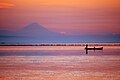
Damavand view from Caspian sea
_from_polur_in_winter_-_panoramio.jpg)
(c) Alireza Javaheri, CC BY 3.0
Damavand (5671) from polur in winter
Mount Damāvand (Persian: دماوند ) also known as Donbavand, a potentially active volcano and the highest peak in Iran, has a special place in Persian mythology and folklore. Located in the middle Alborz Range, adjacent to Varārū, Sesang, Gol-e Zard and Mīānrūd, it is the highest point in the Middle East and the highest volcano in all of Asia. It is a potentially active volcano,since there are fumaroles near the summit crater emitting sulfur, which were known to be active on July 6, 2007. The mountain is located near the southern coast of the Caspian Sea, in Āmol county, Māzandarān, 66 kilometres (41 miles) northeast of Tehran. Contents Symbolism and mythology Damavand is, as any cursory reading of Persian literature will indicate, the Mount Olympus of Persian mythology. Damāvand is the symbol of Iranian resistance against despotism and foreign rule in Persian poetry and literature. In Zoroastrian texts and mythology, the three-headed dragon Aži Dahāka was chained within Mount Damāvand, there to remain until the end of the world. In a later version of the same legend, the tyrant Zahhāk was also chained in a cave somewhere in Mount Damāvand after being defeated by Kāveh and Fereydūn. Persian poet Ferdowsi depicts this event in his masterpiece, the Shahnameh: بیاورد ضحاک را چون نوند به کوه دماوند کردش ببند The mountain is said to hold magical powers in the Shahnameh. Damāvand has also been named in the Iranian legend of Arash as the location he fired his arrow to mark the Iran border. The famous poem Damāvand by Mohammad Taqī Bahār is also one fine example of the mountain's significance in Persian literature. The first verse of this poem reads: ای دیو سپید پای در بند Ay dīve sepīde pāī dar band, Oh white demon with feet in chains ای گنبد گیتی، ای دماوند Ay gonbade gītī, ay Damāvand Oh terrestrial dome, Oh Mount Damāvand Mount Damavand is depicted on the reverse of the Iranian 10,000 rials banknote. [edit] Thermal springs A fumarole near the summit of Damavand, emitting sulfur Mt Damavand has some thermal springs (Abe Garm Larijan) with therapeutic qualities. These mineral hot springs are mainly located on the volcano's flanks and at the base, giving evidence of volcanic heat comparatively near the surface of the earth. While no historic eruptions have been recorded, hot springs at the base and on the flanks, and fumaroles and solfatara near the summit, indicate a hot or cooling magma body still present beneath the volcano, so that Damavand is a potentially active volcano. The most important of these hot springs are located in Abe Garm Larijan in a village by the name Larijan in the district of Larijan in Lar Valley . The water from this spring is useful in the treatment of chronic wounds and skin diseases. Near these springs there are public baths with small pools for public use. Routes to the summit Damavand volcanic crater in August The best major settlement for mountain climbers is the new Iranian Mountain Federation Camp in Polour village, located on the south of the mountain. There are at least 16 known routes[8] to the summit which have different difficulties. Some of them are very dangerous and require rock climbing. The most popular route is the Southern Route which has step stamps and also a camp midway called Bargah Sevom Camp/Shelter[9] at 4220 m (about 13,845 ft). The longest route is the Northeastern and it takes two whole days to reach the summit starting from downhill village of Nāndal and a night stay at Takht-e Fereydoun (elevation 4300 m - about 13,000 ft), a two-story shelter. The western route is famous for its sunset view. Sīmorgh shelter in this route at 4100 m (about 13,500 ft) is a newly constructed shelter with two stories. There is a frozen waterfall/Icefall (Persian name Ābshār Yakhī)about 12m tall and the elevation of 5100m is the highest fall in Iran and Middle East.
(c) Alireza Javaheri, CC BY 3.0
Mount Damavand from Caspian Sea, Bandar Gaz, Iran


Autor: Edit4world, Licencja: CC BY-SA 3.0
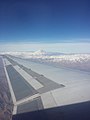
photograph of mount davamand in tehran taken from a plane

(c) Alireza Javaheri, CC BY 3.0
Tehran - Sunset under Damavand in Razi Park
_view_from_Ira_-_panoramio.jpg)
(c) Alireza Javaheri, CC BY 3.0
Damavand (5671) view from Ira
Mount Damāvand (Persian: دماوند ) also known as Donbavand, a potentially active volcano and the highest peak in Iran, has a special place in Persian mythology and folklore. Located in the middle Alborz Range, adjacent to Varārū, Sesang, Gol-e Zard and Mīānrūd, it is the highest point in the Middle East and the highest volcano in all of Asia. It is a potentially active volcano,since there are fumaroles near the summit crater emitting sulfur, which were known to be active on July 6, 2007. The mountain is located near the southern coast of the Caspian Sea, in Āmol county, Māzandarān, 66 kilometres (41 miles) northeast of Tehran. Contents Symbolism and mythology Damavand is, as any cursory reading of Persian literature will indicate, the Mount Olympus of Persian mythology. Damāvand is the symbol of Iranian resistance against despotism and foreign rule in Persian poetry and literature. In Zoroastrian texts and mythology, the three-headed dragon Aži Dahāka was chained within Mount Damāvand, there to remain until the end of the world. In a later version of the same legend, the tyrant Zahhāk was also chained in a cave somewhere in Mount Damāvand after being defeated by Kāveh and Fereydūn. Persian poet Ferdowsi depicts this event in his masterpiece, the Shahnameh: بیاورد ضحاک را چون نوند به کوه دماوند کردش ببند The mountain is said to hold magical powers in the Shahnameh. Damāvand has also been named in the Iranian legend of Arash as the location he fired his arrow to mark the Iran border. The famous poem Damāvand by Mohammad Taqī Bahār is also one fine example of the mountain's significance in Persian literature. The first verse of this poem reads: ای دیو سپید پای در بند Ay dīve sepīde pāī dar band, Oh white demon with feet in chains ای گنبد گیتی، ای دماوند Ay gonbade gītī, ay Damāvand Oh terrestrial dome, Oh Mount Damāvand Mount Damavand is depicted on the reverse of the Iranian 10,000 rials banknote. [edit] Thermal springs A fumarole near the summit of Damavand, emitting sulfur Mt Damavand has some thermal springs (Abe Garm Larijan) with therapeutic qualities. These mineral hot springs are mainly located on the volcano's flanks and at the base, giving evidence of volcanic heat comparatively near the surface of the earth. While no historic eruptions have been recorded, hot springs at the base and on the flanks, and fumaroles and solfatara near the summit, indicate a hot or cooling magma body still present beneath the volcano, so that Damavand is a potentially active volcano. The most important of these hot springs are located in Abe Garm Larijan in a village by the name Larijan in the district of Larijan in Lar Valley . The water from this spring is useful in the treatment of chronic wounds and skin diseases. Near these springs there are public baths with small pools for public use. Routes to the summit Damavand volcanic crater in August The best major settlement for mountain climbers is the new Iranian Mountain Federation Camp in Polour village, located on the south of the mountain. There are at least 16 known routes[8] to the summit which have different difficulties. Some of them are very dangerous and require rock climbing. The most popular route is the Southern Route which has step stamps and also a camp midway called Bargah Sevom Camp/Shelter[9] at 4220 m (about 13,845 ft). The longest route is the Northeastern and it takes two whole days to reach the summit starting from downhill village of Nāndal and a night stay at Takht-e Fereydoun (elevation 4300 m - about 13,000 ft), a two-story shelter. The western route is famous for its sunset view. Sīmorgh shelter in this route at 4100 m (about 13,500 ft) is a newly constructed shelter with two stories. There is a frozen waterfall/Icefall (Persian name Ābshār Yakhī)about 12m tall and the elevation of 5100m is the highest fall in Iran and Middle East.

(c) Alireza Javaheri, CC BY 3.0
Iran - Mazandaran - Damavand view in cold winter

_view_-_panoramio_-_Alireza_Javaheri.jpg)
(c) Alireza Javaheri, CC BY 3.0
Damavand (5671) view
Mount Damāvand (Persian: دماوند ) also known as Donbavand, a potentially active volcano and the highest peak in Iran, has a special place in Persian mythology and folklore. Located in the middle Alborz Range, adjacent to Varārū, Sesang, Gol-e Zard and Mīānrūd, it is the highest point in the Middle East and the highest volcano in all of Asia. It is a potentially active volcano,since there are fumaroles near the summit crater emitting sulfur, which were known to be active on July 6, 2007. The mountain is located near the southern coast of the Caspian Sea, in Āmol county, Māzandarān, 66 kilometres (41 miles) northeast of Tehran. Contents Symbolism and mythology Damavand is, as any cursory reading of Persian literature will indicate, the Mount Olympus of Persian mythology. Damāvand is the symbol of Iranian resistance against despotism and foreign rule in Persian poetry and literature. In Zoroastrian texts and mythology, the three-headed dragon Aži Dahāka was chained within Mount Damāvand, there to remain until the end of the world. In a later version of the same legend, the tyrant Zahhāk was also chained in a cave somewhere in Mount Damāvand after being defeated by Kāveh and Fereydūn. Persian poet Ferdowsi depicts this event in his masterpiece, the Shahnameh: بیاورد ضحاک را چون نوند به کوه دماوند کردش ببند The mountain is said to hold magical powers in the Shahnameh. Damāvand has also been named in the Iranian legend of Arash as the location he fired his arrow to mark the Iran border. The famous poem Damāvand by Mohammad Taqī Bahār is also one fine example of the mountain's significance in Persian literature. The first verse of this poem reads: ای دیو سپید پای در بند Ay dīve sepīde pāī dar band, Oh white demon with feet in chains ای گنبد گیتی، ای دماوند Ay gonbade gītī, ay Damāvand Oh terrestrial dome, Oh Mount Damāvand Mount Damavand is depicted on the reverse of the Iranian 10,000 rials banknote. [edit] Thermal springs A fumarole near the summit of Damavand, emitting sulfur Mt Damavand has some thermal springs (Abe Garm Larijan) with therapeutic qualities. These mineral hot springs are mainly located on the volcano's flanks and at the base, giving evidence of volcanic heat comparatively near the surface of the earth. While no historic eruptions have been recorded, hot springs at the base and on the flanks, and fumaroles and solfatara near the summit, indicate a hot or cooling magma body still present beneath the volcano, so that Damavand is a potentially active volcano. The most important of these hot springs are located in Abe Garm Larijan in a village by the name Larijan in the district of Larijan in Lar Valley . The water from this spring is useful in the treatment of chronic wounds and skin diseases. Near these springs there are public baths with small pools for public use. Routes to the summit Damavand volcanic crater in August The best major settlement for mountain climbers is the new Iranian Mountain Federation Camp in Polour village, located on the south of the mountain. There are at least 16 known routes[8] to the summit which have different difficulties. Some of them are very dangerous and require rock climbing. The most popular route is the Southern Route which has step stamps and also a camp midway called Bargah Sevom Camp/Shelter[9] at 4220 m (about 13,845 ft). The longest route is the Northeastern and it takes two whole days to reach the summit starting from downhill village of Nāndal and a night stay at Takht-e Fereydoun (elevation 4300 m - about 13,000 ft), a two-story shelter. The western route is famous for its sunset view. Sīmorgh shelter in this route at 4100 m (about 13,500 ft) is a newly constructed shelter with two stories. There is a frozen waterfall/Icefall (Persian name Ābshār Yakhī)about 12m tall and the elevation of 5100m is the highest fall in Iran and Middle East.

Autor: Hamed Saber from Tehran, Iran, Licencja: CC BY 2.0
Mount Damāvand


(c) Alireza Javaheri, CC BY 3.0
Iran - Mazandaran - Damavand Volcano View from Rineh Road

Mount Damavand