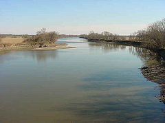
Des Moines River
 Rzeka Des Moines w pobliżu Ottumwa w Iowa | |
| Kontynent | |
|---|---|
| Państwo | |
| Lokalizacja | |
| Rzeka | |
| Długość | 845 km |
| Powierzchnia zlewni | 38 337 km² |
| Średni przepływ | 246 m³/s Ujście do Missisipi |
| Źródło | |
| Miejsce | Lake Shetek Minnesota[1]. |
| Wysokość | 452[2]. |
| Współrzędne | |
| Ujście | |
| Recypient | |
| Miejsce | Missisipi |
| Wysokość | 182 |
| Współrzędne | |
| Mapa | |
 | |
Des Moines River – rzeka w USA, głównie w stanie Iowa[1][3]. Długość rzeki wynosi 845 km, a powierzchnia dorzecza 38 337 km².
Źródła i ujście
Rzeka powstaje z dwóch głównych ramion. Zachodnie (West Fork) ma swój początek w jeziorze Shetek w hrabstwie Murray w Minnesocie, natomiast wschodnie w Okamanpeedan Lake na granicy Minnesoty i Iowa[3]. Rzeka jest lewobrzeżnym dopływem Missisipi, do której uchodzi na granicy stanów Iowa i Missisipi niedaleko miejscowości Keokuk leżącego w hrabstwie Lee.
Zbiorniki
Na rzece są zbudowane dwie główne tamy Saylorville Dam oraz Red Rock Dam. Pierwsza skonstruowana około 18 km powyżej miasta Des Moines tworzy jezioro Saylorville Lake o powierzchni od 24-68 km² (w zależności od poziomu wody w zbiorniku). Drugi zbiornik Red Rock Lake o powierzchni (63-283 km²), leży około 88 km na południe od Des Moines w hrabstwie Marion. Tamy zostały zbudowane w ramach projektów regulacyjnych przez Korpus Inżynieryjny Armii Stanów Zjednoczonych[4].
Rzeka Des Moines jest ceniona jako szlak spływów turystycznych i ma status krajowego szlaku rekreacyjnego[3].
Główne miasta
- Algona
- Armstrong
- Bonaparte
- Chillicothe
- Currie
- Dakota City
- Des Moines
- Douds
- Eddyville
- Eldon
- Estherville
- Farmington
- Fort Dodge
- Fraser
- Graettinger
- Humboldt
- Jackson
- Johnston
- Keokuk
- Keosauqua
- Lehigh
- Leando
- Ottumwa
- Rutland
- Windom
Przypisy
- ↑ a b Feature Detail Report for: Des Moines River. U.S. Geological Survey. Geographic Names Information Ststem. [dostęp 2014-04-19]. (ang.).
- ↑ Feature Detail Report for: Lake Shetek
- ↑ a b c Featured National Recreation Trails, Des Moines River Water Trail. [dostęp 2014-04-19]. (ang.).
- ↑ Des Moines River Regulated Flow Frequency Study. [dostęp 2014-04-19]. (ang.).
Media użyte na tej stronie
Autor: Uwe Dedering, Licencja: CC BY-SA 3.0
Relief location map of the USA (without Hawaii and Alaska).
EquiDistantConicProjection : Central parallel :
* N: 37.0° N
Central meridian :
* E: 96.0° W
Standard parallels:
* 1: 32.0° N
* 2: 42.0° N
Made with Natural Earth. Free vector and raster map data @ naturalearthdata.com.
Formulas for x and y:
x = 50.0 + 124.03149777329222 * ((1.9694462586094064-({{{2}}}* pi / 180))
      * sin(0.6010514667026994 * ({{{3}}} + 96) * pi / 180))
y = 50.0 + 1.6155950752393982 * 124.03149777329222 * 0.02613325650382181
      - 1.6155950752393982  * 124.03149777329222 *
     (1.3236744353715044  - (1.9694462586094064-({{{2}}}* pi / 180))
      * cos(0.6010514667026994 * ({{{3}}} + 96) * pi / 180))
The flag of Navassa Island is simply the United States flag. It does not have a "local" flag or "unofficial" flag; it is an uninhabited island. The version with a profile view was based on Flags of the World and as a fictional design has no status warranting a place on any Wiki. It was made up by a random person with no connection to the island, it has never flown on the island, and it has never received any sort of recognition or validation by any authority. The person quoted on that page has no authority to bestow a flag, "unofficial" or otherwise, on the island.
Red Rock Dam and Lake, also known as Red Rock Reservoir, on the Des Moines River in Marion County, Iowa. The U.S. Army Corps of Engineers constructed the dam in 1969 for flood control on the Des Moines River. The dam is located approximately 36 miles (58 km) east-southeast of the city of Des Moines, Iowa. County highway T15 crosses the dam. View is to the north. Photograph color-corrected by contributor.
Autor: Kmusser, Licencja: CC BY-SA 2.5
Map of the Des Moines River watershed in Iowa and Minnesota.


