Deux-Sèvres
| Departament | |||||
 | |||||
| Państwo | |||||
|---|---|---|---|---|---|
| Region | |||||
| Prefektura | |||||
| Kod ISO 3166-2 | FR-79 | ||||
| Powierzchnia | 5999 km² | ||||
| Populacja (2018[1]) • liczba ludności |
| ||||
| • gęstość | 62 os./km² | ||||
| Szczegółowy podział administracyjny | |||||
| Liczba podprefektur | 2 | ||||
| Liczba kantonów | 33 | ||||
| Liczba gmin | 305 | ||||
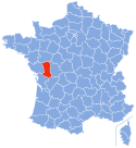
Położenie na mapie | |||||
| Portal | |||||
Deux-Sèvres – francuski departament w regionie Nowa Akwitania. Utworzony został 4 marca 1790, podczas rewolucji francuskiej. Departament oznaczony jest liczbą 79. Jego nazwę można przetłumaczyć, jako "dwie Sèvres", a pochodzi ona od dwóch rzek, które mają swoje źródła w tym departamencie: Sèvre Nantaise i Sèvre Niortaise.
Według danych na 2018 r. powierzchnia departamentu wynosi 5 999 km², a zamieszkuje go 374 799 osób (średnia: 62 os./km²). Prefektura Deux-Sèvres mieści się w mieście Niort.
Liczba gmin w departamencie wynosi 307.
Zobacz też
- Gminy departamentu Deux-Sèvres
Przypisy
- ↑ Populations légales 2018 pour les départements et les collectivités d’outre-mer (fr.). insee.fr. [dostęp 2019-09-09].
Media użyte na tej stronie
Autor: Selbymay, Licencja: CC BY-SA 3.0
This building is inscrit au titre des monuments historiques de la France. It is indexed in the base Mérimée, a database of architectural heritage maintained by the French Ministry of Culture, under the reference PA79000018
Autor: Marmelad, Licencja: CC BY-SA 2.5
Autogenerated image to indicate departement given by filename.
Autor: Superbenjamin, Licencja: CC BY-SA 4.0
Blason de la région Nouvelle-Aquitaine
Autor: Chabe01, Licencja: CC BY-SA 4.0
Drapeau du département des Deux-Sèvres (en référence au blason).


