Dharamsala
 Położenie Dharamsali | |
| Państwo | |
|---|---|
| Stan | |
| Dystrykt | Kangra |
| Powierzchnia | 27.60 km2 km² |
| Wysokość | 1457 m n.p.m. |
| Populacja (2015) • liczba ludności • gęstość |
|
| Nr kierunkowy | 1892 |
| Kod pocztowy | 176215 |
Położenie na mapie Himachal Pradeshu  | |
Położenie na mapie Indii | |
| Strona internetowa | |
Dharamsala (lub też Dharamśala, hindi: धर्मशाला) – miasto w północnych Indiach w stanie Himachal Pradesh, w zachodnich Himalajach.
Populacja miasta w 2015 roku wynosiła 62,596 mieszkańców[1]. Jest to również zimowa stolica prowincji. Służy jako siedziba siedziby administracyjnej dystryktu Kangra po przeniesieniu ich z Kangra, miasta położonego 18 kilometrów od Dharamsali, w 1855 roku.
W pobliżu Dharamsali, w McLeod Ganj, położony jest główny ośrodek tybetańskiej emigracji w Indiach, nazywany niekiedy "Małą Lhasą", który od 1960 roku jest miejscem zamieszkania XIV Dalajlamy i siedzibą Tybetańskiego Rządu na Uchodźstwie.
Demografia
Według spisu powszechnego w Indiach z 2001 r.[2] Dharamszala liczyła 30 764 mieszkańców. Według stanu na 2015 r. ma 62 596 mieszkańców, ze względu na wzrost to że, jego powierzchnia wzrosła, gdy stała się korporacją komunalną. Mężczyźni stanowią 55% populacji, a kobiety 45%. Dharamsala ma średni wskaźnik alfabetyzmu wynoszący 87%, wyższy niż średnia krajowa wynosząca 74,04%: alfabetyzm mężczyzn wynosi 90%, a alfabetyzm kobiet 83%. W Dharamsali tylko 9% populacji ma mniej niż 6 lat.
Według spisu powszechnego Indii z i Municipal Corporation 2015[3]w Dharamsala:
- Liczba gospodarstw domowych – 10 992
- Średnia wielkość gospodarstwa domowego (na gospodarstwo domowe) – 4,0
- Populacja ogółem – 62 596
- Proporcja ludności miejskiej (%) – 100
- Stosunek płci – 941
- Populacja (0–6 lat) – 1819
- Stosunek płci (SC) – 861
- Wskaźnik alfabetyzacji (%) – 87,0
Języki, którymi najczęściej posługują się mieszkańcy Dharamsali to hindi, angielski, tybetański, nepalski i pahari.
Galeria
- Dharamsala


Przypisy
Media użyte na tej stronie

(c) Uwe Dedering z niemieckiej Wikipedii, CC BY-SA 3.0
Location map of India.
Equirectangular projection. Strechted by 106.0%. Geographic limits of the map:
- N: 37.5° N
- S: 5.0° N
- W: 67.0° E
- E: 99.0° E

The Flag of India. The colours are saffron, white and green. The navy blue wheel in the center of the flag has a diameter approximately the width of the white band and is called Ashoka's Dharma Chakra, with 24 spokes (after Ashoka, the Great). Each spoke depicts one hour of the day, portraying the prevalence of righteousness all 24 hours of it.

Autor: Gerd Eichmann, Licencja: CC BY-SA 4.0
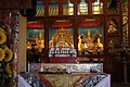
Karmapas Gyuto Monastery in Dharamsala, Himachal Pradesh, India

Autor: Gerd Eichmann, Licencja: CC BY-SA 4.0
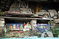
Tse Chok Ling monastery in Dharamsala, Himachal Pradesh, India

Autor: Gerd Eichmann, Licencja: CC BY-SA 4.0
Kora in Dharamsala, Himachal Pradesh, India

Autor: Gerd Eichmann, Licencja: CC BY-SA 4.0
Norbulingka Institute in Dharamsala, Himachal Pradesh, India
Autor:
This Image was created by User:PlaneMad.
|

Autor: Gerd Eichmann, Licencja: CC BY-SA 4.0
McLeod Ganj in Dharamsala, Himachal Pradesh, India

Autor: Gerd Eichmann, Licencja: CC BY-SA 4.0
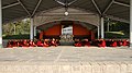
SOS Children's Village in Dharamsala, Himachal Pradesh, India

Autor: Gerd Eichmann, Licencja: CC BY-SA 4.0
Tse Chok Ling monastery in Dharamsala, Himachal Pradesh, India

Autor: Gerd Eichmann, Licencja: CC BY-SA 4.0
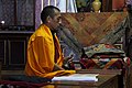
Dolma Ling monastery in Dharamsala, Himachal Pradesh, India