Diecezja Bridgeport
 St. Augustine Cathedral | |
| Państwo | |
|---|---|
| Siedziba | Bridgeport, CT |
| Data powołania | 6 sierpnia 1953 |
| Wyznanie | |
| Kościół | |
| Metropolia | Hartford |
| Katedra diecezjalna | Katedra św. Augustyna w Bridgeport |
| Biskup diecezjalny | |
| Dane statystyczne (2008) | |
| Liczba wiernych | 410 091 |
| Liczba kapłanów | 242 |
| Liczba parafii | 87 |
| Powierzchnia | 1639 km² |
| Strona internetowa | |
Diecezja Bridgeport (łac. Dioecesis Bridgeportensis, ang. Diocese of Bridgeport) jest diecezją Kościoła rzymskokatolickiego w Bridgeport, region Nowa Anglia, Stany Zjednoczone.
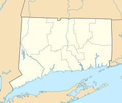
Terytorialnie obejmuje hrabstwo Fairfield w stanie Connecticut.
Historia
Diecezja została ustanowiona 6 sierpnia 1953 z Diecezji Hartford
Poprzedni ordynariusze
- Lawrence Shehan (1953-1961)
- Walter William Curtis (1961-1988)
- Edward Egan (1988-2000)
- William Lori (2001-2012)
- Frank Caggiano (od 2013)
Szkoły
Uczelnie
- Fairfield University
- Sacred Heart University
- St. Vincent's College in Bridgeport
Szkoły średnie
- Convent of the Sacred Heart, Greenwich
- Fairfield College Preparatory School, Fairfield
- Immaculate High School, Danbury
- Kolbe Cathedral High School, Bridgeport
- Notre Dame Catholic High School, Fairfield
- St. Joseph High School, Trumbull
- Trinity Catholic High School, Stamford
Bibliografia
- Oficjalna strona Diecezji Bridgeport (en)
- Catholic Hierarchy Profile of the Diocese of Bridgeport (en)
Skandal 2006
Proboszcz parafii św. Jana w Darien, ks. Michael Jude Fay, wziął 1,4 milionów dolarów z funduszów kościoła w ciągu sześciu lat, na pokrycie luksusowego życia, według raportu przygotowanego przez zewnętrznych audytorów sądowych zatrudnionych przez diecezję[1].
Przypisy
- ↑ [1], Cowan, Alison Leigh, "Auditors Say Priest Took $1.4 Million Before Ouster," article, The New York Times, regional news section, July 29, 2006.
Zobacz też
Media użyte na tej stronie
Autor: Uwe Dedering, Licencja: CC BY-SA 3.0
Location map of the USA (without Hawaii and Alaska).
EquiDistantConicProjection:
Central parallel:
* N: 37.0° N
Central meridian:
* E: 96.0° W
Standard parallels:
* 1: 32.0° N
* 2: 42.0° N
Made with Natural Earth. Free vector and raster map data @ naturalearthdata.com.
Formulas for x and y:
x = 50.0 + 124.03149777329222 * ((1.9694462586094064-({{{2}}}* pi / 180))
      * sin(0.6010514667026994 * ({{{3}}} + 96) * pi / 180))
y = 50.0 + 1.6155950752393982 * 124.03149777329222 * 0.02613325650382181
      - 1.6155950752393982  * 124.03149777329222 *
     (1.3236744353715044  - (1.9694462586094064-({{{2}}}* pi / 180))
      * cos(0.6010514667026994 * ({{{3}}} + 96) * pi / 180))
The flag of Navassa Island is simply the United States flag. It does not have a "local" flag or "unofficial" flag; it is an uninhabited island. The version with a profile view was based on Flags of the World and as a fictional design has no status warranting a place on any Wiki. It was made up by a random person with no connection to the island, it has never flown on the island, and it has never received any sort of recognition or validation by any authority. The person quoted on that page has no authority to bestow a flag, "unofficial" or otherwise, on the island.
Japanese map symbol "Church". U+26EA
Autor: Alexrk2, Licencja: CC BY 3.0
Ta mapa została stworzona za pomocą GeoTools.
Autor: Farragutful, Licencja: CC BY-SA 4.0
St. Augustine Cathedral in Bridgeport, Connecticut.


