Diecezja Cheyenne
 | |
| Państwo | |
|---|---|
| Siedziba | Cheyenne |
| Data powołania | 2 sierpnia 1887 |
| Wyznanie | |
| Kościół | |
| Metropolia | Denver |
| Katedra diecezjalna | Katedra Najświętszej Maryi Panny w Cheyenne |
| Biskup diecezjalny | |
| Biskup senior | bp Joseph Hart |
| Dane statystyczne (2013) | |
| Liczba wiernych • odsetek wiernych | 56 100 |
| Liczba kapłanów • w tym diecezjalnych • w tym zakonnych | 70 |
| Liczba osób zakonnych | 20 |
| Liczba parafii | 33 |
| Powierzchnia | 252 552 km² |
| Strona internetowa | |
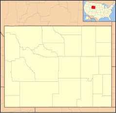
Diecezja Cheyenne (łac. Dioecesis Cheyennensis, ang. Diocese of Cheyenne) jest diecezją Kościoła rzymskokatolickiego w USA obejmującą terytorialnie cały stan Wyoming.
Historia
Diecezja została kanonicznie erygowana 2 sierpnia 1887 przez papieża Leona XIII. Wyodrębniono ją z ówczesnej diecezji Omaha. Pierwszym ordynariuszem został dotychczasowy kapłan archidiecezji Chicago Maurice Francis Burke.
Ordynariusze
- Maurice Francis Burke (1887-1893)
- Thomas Mathias Lenihan (1896-1901)
- James John Keane (1902-1911)
- Patrick Aloysius Alphonsus McGovern (1912-1951)
- Hubert Michael Newell (1951-1978)
- Joseph Hart (1978-2001)
- David Ricken (2001-2008)
- Paul Etienne (2009-2016)
- Steven Biegler (od 2017)
Bibliografia
- Oficjalna strona internetowa diecezji Cheyenne
- Diecezja Cheyenne w bazie catholic-hierarchy.org (ang.)
Media użyte na tej stronie
Autor: Uwe Dedering, Licencja: CC BY-SA 3.0
Location map of the USA (without Hawaii and Alaska).
EquiDistantConicProjection:
Central parallel:
* N: 37.0° N
Central meridian:
* E: 96.0° W
Standard parallels:
* 1: 32.0° N
* 2: 42.0° N
Made with Natural Earth. Free vector and raster map data @ naturalearthdata.com.
Formulas for x and y:
x = 50.0 + 124.03149777329222 * ((1.9694462586094064-({{{2}}}* pi / 180))
      * sin(0.6010514667026994 * ({{{3}}} + 96) * pi / 180))
y = 50.0 + 1.6155950752393982 * 124.03149777329222 * 0.02613325650382181
      - 1.6155950752393982  * 124.03149777329222 *
     (1.3236744353715044  - (1.9694462586094064-({{{2}}}* pi / 180))
      * cos(0.6010514667026994 * ({{{3}}} + 96) * pi / 180))
The flag of Navassa Island is simply the United States flag. It does not have a "local" flag or "unofficial" flag; it is an uninhabited island. The version with a profile view was based on Flags of the World and as a fictional design has no status warranting a place on any Wiki. It was made up by a random person with no connection to the island, it has never flown on the island, and it has never received any sort of recognition or validation by any authority. The person quoted on that page has no authority to bestow a flag, "unofficial" or otherwise, on the island.
Japanese map symbol "Church". U+26EA
Autor: Farragutful, Licencja: CC BY-SA 3.0
Catholic Diocese of Cheyenne encompasses the entire state of Wyoming, USA.
Autor: Alekjds, Licencja: CC BY 1.0
This is a representation of the coat of arms of the Roman Catholic Diocese of Cheyenne.
Blazon: Parted per fess crennelly Gules and Argent two crosses paty in pale counterchanged.
The following Commons images were used to create this image:
Ta ^specifik^ z W3C grafika wektorowa została stworzona za pomocą Inkscape.


