Diecezja Południa
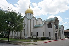
(c) Michael Barera, CC BY-SA 4.0 Sobór katedralny | |
| Państwo | |
|---|---|
| Stan | |
| Siedziba | |
| Data powołania | 1978 |
| Wyznanie | |
| Kościół | |
| Katedra diecezjalna | |
| Biskup diecezjalny | arcybiskup Dallas, Południa i Diecezji Bułgarskiej Aleksander (Golitzin)[1] |
| Biskup pomocniczy | biskup Fort Worth Gerazym (Eliel) |
| Strona internetowa | |
Diecezja Południa – jedna z 11 terytorialnych jednostek administracyjnych Kościoła Prawosławnego w Ameryce. Obejmuje stany Alabama, Arkansas, Floryda, Georgia, Kentucky, Luizjana, Missisipi, Karolina Północna, Karolina Południowa, Nowy Meksyk, Oklahoma, Tennessee, Teksas i Wirginia[2]. Katedrą diecezji jest sobór św. Serafina z Sarowa w Dallas[3].
Diecezja dzieli się na sześć dekanatów[4]:
- Dekanat Appalachów
- Dekanat Karoliny
- Dekanat Florydy Środkowej
- Dekanat południowo-centralny
- Dekanat południowo-wschodni
- Dekanat Florydy Południowej.
Łącznie na ich terenie działa 70 parafii i placówek misyjnych[2] oraz klasztory: męski skit św. Michała Archanioła w Canones[5], monaster Narodzenia Pańskiego w Dallas[6] oraz monaster Świętych Marty i Marii w Wagener (żeński)[7].
Przypisy
- ↑ The Holy Synod of Bishops and Episcopacy. [dostęp 2011-01-10]. [zarchiwizowane z tego adresu (2010-06-16)].
- ↑ a b Parishes
- ↑ St. Seraphim of Sarov Cathedral
- ↑ Diocese of the South. [dostęp 2010-04-06]. [zarchiwizowane z tego adresu (2010-03-15)].
- ↑ Monastery of the Holy Archangel Michael
- ↑ Nativity of Our Lord Monastery
- ↑ SS. Mary & Martha Monastery
Media użyte na tej stronie
Autor: Uwe Dedering, Licencja: CC BY-SA 3.0
Location map of the USA (without Hawaii and Alaska).
EquiDistantConicProjection:
Central parallel:
* N: 37.0° N
Central meridian:
* E: 96.0° W
Standard parallels:
* 1: 32.0° N
* 2: 42.0° N
Made with Natural Earth. Free vector and raster map data @ naturalearthdata.com.
Formulas for x and y:
x = 50.0 + 124.03149777329222 * ((1.9694462586094064-({{{2}}}* pi / 180))
      * sin(0.6010514667026994 * ({{{3}}} + 96) * pi / 180))
y = 50.0 + 1.6155950752393982 * 124.03149777329222 * 0.02613325650382181
      - 1.6155950752393982  * 124.03149777329222 *
     (1.3236744353715044  - (1.9694462586094064-({{{2}}}* pi / 180))
      * cos(0.6010514667026994 * ({{{3}}} + 96) * pi / 180))
The flag of Navassa Island is simply the United States flag. It does not have a "local" flag or "unofficial" flag; it is an uninhabited island. The version with a profile view was based on Flags of the World and as a fictional design has no status warranting a place on any Wiki. It was made up by a random person with no connection to the island, it has never flown on the island, and it has never received any sort of recognition or validation by any authority. The person quoted on that page has no authority to bestow a flag, "unofficial" or otherwise, on the island.
Japanese map symbol "Church". U+26EA
Autor: Alexrk, Licencja: CC BY 3.0
Ta mapa została stworzona za pomocą GeoTools.
(c) Michael Barera, CC BY-SA 4.0
St. Seraphim Orthodox Cathedral in Highland Park, Texas (United States).


