Diecezja Victoria w Teksasie
 | |
| Państwo | |
|---|---|
| Siedziba | Victoria Chancery Office, 1505 E. Mesquite Lane, P.O. Box 4070, VIctoria, TX 77903-4070 |
| Data powołania | 13 kwietnia 1982 |
| Wyznanie | katolickie |
| Kościół | rzymskokatolicki |
| Metropolia | Galveston-Houston |
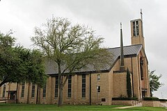
| Katedra diecezjalna | Katedra Matki Bożej Zwycięskiej w Victorii |
| Biskup diecezjalny | Brendan Cahill |
| Biskup senior | David Fellhauer |
| Dane statystyczne (2010) | |
| Liczba wiernych • odsetek wiernych | 116 049 40,9% |
| Liczba kapłanów • w tym diecezjalnych • w tym zakonnych | 60 53 7 |
| Liczba osób zakonnych | 93 |
| Liczba parafii | 50 |
| Powierzchnia | 23 573 km² |
| Strona internetowa | |
Diecezja Victoria w Teksasie (łac. Dioecesis Victoriensis in Texia, ang. Diocese of Victoria in Texas) jest diecezją Kościoła rzymskokatolickiego w metropolii Galveston-Houston w Stanach Zjednoczonych we wschodniej części stanu Teksas.
Historia
Diecezja została kanonicznie erygowana 13 kwietnia 1982 roku przez papieża Jana Pawła II. Wyodrębniono ją z diecezji Corpus Christi, Galveston-Houston i San Antonio. Pierwszym ordynariuszem został dotychczasowy biskup pomocniczy San Antonio Charles Grahmann (ur. 1931).
Ordynariusze
- Charles Grahmann (1982-1989)
- David Fellhauer (1990-2015)
- Brendan Cahill (od 2015)
Bibliografia
- Oficjalna strona internetowa diecezji Victoria (ang.)
- Diecezja Victoria w Teksasie w bazie catholic-hierarchy.org (ang.)
Media użyte na tej stronie
Autor: Uwe Dedering, Licencja: CC BY-SA 3.0
Location map of the USA (without Hawaii and Alaska).
EquiDistantConicProjection:
Central parallel:
* N: 37.0° N
Central meridian:
* E: 96.0° W
Standard parallels:
* 1: 32.0° N
* 2: 42.0° N
Made with Natural Earth. Free vector and raster map data @ naturalearthdata.com.
Formulas for x and y:
x = 50.0 + 124.03149777329222 * ((1.9694462586094064-({{{2}}}* pi / 180))
      * sin(0.6010514667026994 * ({{{3}}} + 96) * pi / 180))
y = 50.0 + 1.6155950752393982 * 124.03149777329222 * 0.02613325650382181
      - 1.6155950752393982  * 124.03149777329222 *
     (1.3236744353715044  - (1.9694462586094064-({{{2}}}* pi / 180))
      * cos(0.6010514667026994 * ({{{3}}} + 96) * pi / 180))
The flag of Navassa Island is simply the United States flag. It does not have a "local" flag or "unofficial" flag; it is an uninhabited island. The version with a profile view was based on Flags of the World and as a fictional design has no status warranting a place on any Wiki. It was made up by a random person with no connection to the island, it has never flown on the island, and it has never received any sort of recognition or validation by any authority. The person quoted on that page has no authority to bestow a flag, "unofficial" or otherwise, on the island.
Japanese map symbol "Church". U+26EA
Autor: Alexrk, Licencja: CC BY 3.0
Ta mapa została stworzona za pomocą GeoTools.
Autor: Our-Lady-of-Victory Parish, Licencja: CC BY-SA 4.0
View from the outside of the Cathedral Our Lady of Victory, mother church of the diocese of Victoria in Texas
Autor: Croberto68, Licencja: CC BY-SA 3.0
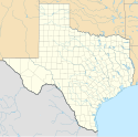
Map of the Catholic diocese of Victoria in the USA.


