Dingboche
| Niektóre z zamieszczonych tu informacji wymagają weryfikacji. |
| ||
.jpg) | ||
| Państwo | ||
| Kod pocztowy | 56002 | |
Położenie na mapie Nepalu  (c) Karte: NordNordWest, Lizenz: Creative Commons by-sa-3.0 de | ||
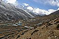
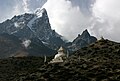
Dingboche – nepalska osada w regionie Khumbu, położona w dolinie Chukhung na wysokości około 4530 m n.p.m. Dingboche jest często odwiedzana przez turystów i himalaistów zdobywających Mount Everest, Ama Dablam lub Imja Tse. Grupy wspinaczkowe zazwyczaj zatrzymują się tu na dwa dni w celach aklimatyzacyjnych. Mieszkańcy utrzymują się głównie z odwiedzających – teren wioski to w większości pola namiotowe. Rzeka Imja przepływa przez wschodnią część osady.
- Dingboche


Media użyte na tej stronie
Nepal adm location map.svg
(c) Karte: NordNordWest, Lizenz: Creative Commons by-sa-3.0 de
Location map of Nepal including the 7 provinces
(c) Karte: NordNordWest, Lizenz: Creative Commons by-sa-3.0 de
Location map of Nepal including the 7 provinces


Dingboche-42-2007-gje.jpg
Autor: Gerd Eichmann, Licencja: CC BY-SA 4.0
Village in the VDC Khumjung in Solukhumbu District in Nepal
Autor: Gerd Eichmann, Licencja: CC BY-SA 4.0
Village in the VDC Khumjung in Solukhumbu District in Nepal

Dingboche-66-Choerten-Berge-2007-gje.jpg
Autor: Gerd Eichmann, Licencja: CC BY-SA 4.0
Village in the VDC Khumjung in Solukhumbu District in Nepal
Autor: Gerd Eichmann, Licencja: CC BY-SA 4.0
Village in the VDC Khumjung in Solukhumbu District in Nepal

Dingboche-14-2007-gje.jpg
Autor: Gerd Eichmann, Licencja: CC BY-SA 4.0
Village in the VDC Khumjung in Solukhumbu District in Nepal
Autor: Gerd Eichmann, Licencja: CC BY-SA 4.0
Village in the VDC Khumjung in Solukhumbu District in Nepal

Dingboche-26-Lodge-2007-gje.jpg
Autor: Gerd Eichmann, Licencja: CC BY-SA 4.0
Village in the VDC Khumjung in Solukhumbu District in Nepal
Autor: Gerd Eichmann, Licencja: CC BY-SA 4.0
Village in the VDC Khumjung in Solukhumbu District in Nepal

Dingboche-20-2007-gje.jpg
Autor: Gerd Eichmann, Licencja: CC BY-SA 4.0
Village in the VDC Khumjung in Solukhumbu District in Nepal
Autor: Gerd Eichmann, Licencja: CC BY-SA 4.0
Village in the VDC Khumjung in Solukhumbu District in Nepal

Dingboche-34-Kartoffelbauern-2007-gje.jpg
Autor: Gerd Eichmann, Licencja: CC BY-SA 4.0
Village in the VDC Khumjung in Solukhumbu District in Nepal
Autor: Gerd Eichmann, Licencja: CC BY-SA 4.0
Village in the VDC Khumjung in Solukhumbu District in Nepal