Dione (księżyc)
| ||
 Zdjęcie Dione z sondy Cassini, ukazujące charakterystyczne białe linie – wielkie lodowe klify. | ||
| Planeta | Saturn | |
| Odkrywca | Giovanni Cassini | |
| Data odkrycia | 21 marca 1684 | |
| Charakterystyka orbity | ||
| Półoś wielka | 377 415 km[1] | |
| Mimośród | 0,0022[1] | |
| Okres obiegu | 2,737 d[1] | |
| Nachylenie do płaszczyzny Laplace’a | 0,028°[1] | |
| Długość węzła wstępującego | 290,415°[1] | |
| Argument perycentrum | 284,315°[1] | |
| Anomalia średnia | 322,232°[1] | |
| Własności fizyczne | ||
| Średnica równikowa | 1118 km | |
| Masa | 1,096×1021 kg | |
| Średnia gęstość | 1,50 g/cm³ | |
| Przyspieszenie grawitacyjne na powierzchni | 0,231 m/s² | |
| Prędkość ucieczki | 0,510 km/s | |
| Okres obrotu wokół własnej osi | synchroniczny | |
| Jasność obserwowana (z Ziemi) | 10m | |
| Temperatura powierzchni | 87 K | |
Dione (Saturn IV ) – czwarty pod względem wielkości księżyc Saturna. Został odkryty przez Giovanniego Cassiniego wraz z Tetydą w roku 1684. Jego nazwa pochodzi z mitologii greckiej. Dione była matką Afrodyty.
Ten naturalny satelita krąży wokół Saturna po orbicie kołowej, z okresem obiegu 65 godzin 41 minut i 5 sekund. Dwa nieregularne księżyce Saturna, Helena i Polideukes, poruszają się po tej samej orbicie co Dione w punktach Lagrange’a, są to więc tzw. księżyce trojańskie. Helena znajduje się w punkcie L4 orbity, a Polideukes w punkcie L5. Dione jest ponadto w rezonansie orbitalnym 1:2 z Enceladusem.
Nazwa
Giovanni Cassini nazwał cztery odkryte przez siebie księżyce (Tetyda, Dione, Rea, Japet) imieniem Sidera Lodoicea (gwiazdami Ludwika) na cześć króla Ludwika XIV. Astronomowie zwykle nadawali księżycom nazwy odnoszące się do planety, wokół której krążyły, np. Tytan został nazwany Saturn VI. Jednak nazwy siedmiu największych księżyców pochodzą od Johna Herschela (syna Williama Herschela, odkrywcy Urana oraz księżyców Mimasa i Enceladusa). Po raz pierwszy zostały użyte w jego publikacji Rezultaty Astronomicznych Obserwacji z 1847[2].
Charakterystyka fizyczna
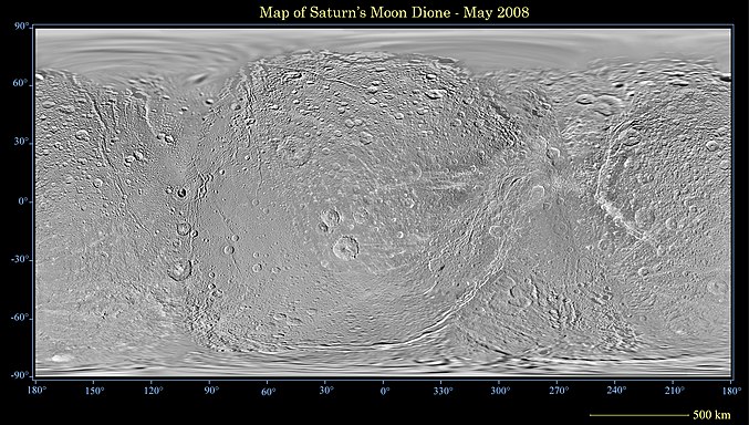
Mapa Dione wykonana w maju 2008 przez sondę Cassini-Huygens
Dione jest księżycem lodowym, zbudowanym w większości z wodnego lodu z domieszką materiału skalnego. Pod warstwą lodu znajduje się skalne jądro. Dione ma zróżnicowaną powierzchnię. Na półkuli zwróconej w kierunku Saturna przeważającą część krajobrazu stanowią kratery uderzeniowe. Na drugiej półkuli Dione widać sieć linii biegnących przez całą półkulę. Są to lodowe klify, zapewne pochodzenia tektonicznego, wysokie nawet na kilkaset metrów. Do największych z nich należą Carthage Linea i Palatine Linea. Większość nazw utworów powierzchniowych Dione pochodzi z Eneidy Wergiliusza.
W 2010 sonda Cassini-Huygens wykryła bardzo cienką warstwę zjonizowanego tlenu (O+
2) rozciągającą się nad księżycem. Gęstość tej śladowej atmosfery, określanej mianem egzosfery, wynosi jedynie jeden jon na 11 centymetrów sześciennych (w jednym metrze sześciennym jest ich około 90 000, czyli 5 bilionów razy mniej niż na Ziemi)[3][4]. Oznacza to, że egzosfera Dione jest tak gęsta jak atmosfera Ziemi na wysokości 480 kilometrów[3], czyli daleko poza granicą przestrzeni kosmicznej.
Zobacz też
- Chronologiczny wykaz odkryć planet, planet karłowatych i ich księżyców w Układzie Słonecznym
- Księżyce Saturna – zestawienie podstawowych danych
- Największe księżyce Saturna: Tytan, Rea, Japet, Tetyda i Enceladus
Przypisy
- ↑ a b c d e f g Planetary Satellite Mean Orbital Parameters (ang.). Jet Propulsion Laboratory, 2013-08-23. [dostęp 2016-02-22].
- ↑ Observations of the Satellites of Saturn. W: John Herschel: Results of astronomical observations made during the years 1834, 5, 6, 7, 8, at the Cape of Good Hope; being the completion of a telescopic survey of the whole surface of the visible heavens, commenced in 1825. Londyn: Smith, Elder and Co., 1847, s. 415. [dostęp 2016-02-22].
- ↑ a b Saturn's Icy Moon Dione Has Oxygen Atmosphere (ang.). Space, 2012-03-02. [dostęp 2012-03-04].
- ↑ Odkryto tlen w atmosferze jednego z księżyców Saturna (pol.). Odkrywcy, 2012-03-05. [dostęp 2013-07-16]. [zarchiwizowane z tego adresu (2012-04-18)].
Linki zewnętrzne
- Dione. W: Księżyce Układu Słonecznego [on-line]. [dostęp 2009-11-09]. [zarchiwizowane z tego adresu (2012-02-19)].
- Dione (ang.). W: Solar System Exploration [on-line]. NASA. [dostęp 2018-12-26].
- Nazwane struktury na powierzchni Dione (ang.). W: Gazetteer of Planetary Nomenclature [on-line]. IAU, USGS, NASA. [dostęp 2016-02-22].
| Księżyce pasterskie (6) | |
|---|---|
| Księżyce koorbitalne (2) | |
| Pierścień G (1) | |
| Alkyonidy (3) | |
| Duże wewnętrzne (4) z księżycami trojańskimi (4) | |
| Duże zewnętrzne (4) | |
| Grupa inuicka (7) | |
| Grupa nordycka (46) |
|
| Grupa galijska (5) | |
| Orbita wyznaczona z dużą niepewnością |
![]()
- Lista jest posortowana według odległości od Saturna. Największe księżyce mają nazwy pogrubione. Nazwy tymczasowe opisano kursywą.
| Główne księżyce | |
|---|---|
| Charakterystyka | |
| Badania Saturna | |
| Inne tematy |
_large.jpg)
| Planety (☾ ∅) | |||||||||||||||||
|---|---|---|---|---|---|---|---|---|---|---|---|---|---|---|---|---|---|
| Planety karłowate | |||||||||||||||||
| Małe ciała Układu Słonecznego |
| ||||||||||||||||
- Zobacz też
- powstanie i ewolucja Układu Słonecznego
- ciała niebieskie
- lista obiektów w Układzie Słonecznym ze względu na
- Portal: Astronomia
- ciała niebieskie
Media użyte na tej stronie

This is a revised version of Solar_System_XXIX.png.

Saturn Cassini-Huygens (NASA)
Instrument: Imaging Science Subsystem - Narrow Angle
Saturn's peaceful beauty invites the Cassini spacecraft for a closer look in this natural color view, taken during the spacecraft's approach to the planet. By this point in the approach sequence, Saturn was large enough that two narrow angle camera images were required to capture an end-to-end view of the planet, its delicate rings and several of its icy moons. The composite is made entire from these two images.
Moons visible in this mosaic: Epimetheus (116 kilometers, 72 miles across), Pandora (84 kilometers, 52 miles across) and Mimas (398 kilometers, 247 miles across) at left of Saturn; Prometheus (102 kilometers, 63 miles across), Janus (181 kilometers, 113 miles across) and Enceladus (499 kilometers, 310 miles across) at right of Saturn.
The images were taken on May 7, 2004 from a distance of 28.2 million kilometers (17.6 million miles) from Saturn. The image scale is 169 kilometers (105 miles) per pixel. Moons in the image have been brightened for visibility.
The Cassini-Huygens mission is a cooperative project of NASA, the European Space Agency and the Italian Space Agency. The Jet Propulsion Laboratory, a division of the California Institute of Technology in Pasadena, manages the Cassini-Huygens mission for NASA's Office of Space Science, Washington, D.C. The Cassini orbiter and its two onboard cameras, were designed, developed and assembled at JPL. The imaging team is based at the Space Science Institute, Boulder, Colo.
For more information, about the Cassini-Huygens mission visit, http://saturn.jpl.nasa.gov and the Cassini imaging team home page, http://ciclops.org.This true color picture was assembled from Voyager 2 Saturn images obtained Aug. 4 [1981] from a distance of 21 million kilometers (13 million miles) on the spacecraft's approach trajectory. Three of Saturn's icy moons are evident at left. They are, in order of distance from the planet: Tethys, 1,050 km. (652 mi.) in diameter; Dione, 1,120 km. (696 mi.); and Rhea, 1,530 km. (951 mi.). The shadow of Tethys appears on Saturn's southern hemisphere. A fourth satellite, Mimas, is less evident, appearing as a bright spot a quarter-inch in in from the planet's limb about half an inch above Tethys; the shadow of Mimas appears on the planet about three-quarters of an inch directly above that of Tethys. The pastel and yellow hues on the planet reveal many contrasting bright and darker bands in both hemispheres of Saturn's weather system. The Voyager project is managed for NASA by the Jet Propulsion Laboratory, Pasadena, California, United States.

This global map of Saturn's moon Dione was created using images taken during Cassini spacecraft flybys, with Voyager images filling in the gaps in Cassini's coverage.
An extensive system of bright ice cliffs created by tectonic fractures adorns the moon's trailing hemisphere.
The map is a simple cylindrical (equidistant) projection and has a scale of 614 meters (2,014 feet) per pixel at the equator. The mean radius of Dione used for projection of this map is 562 kilometers (349 miles). This updated map has been shifted west by 0.6 degrees of longitude, compared to the previously released Cassini product (PIA08341), in order to conform to the International Astronomical Union longitude system convention for Dione.
The Cassini-Huygens mission is a cooperative project of NASA, the European Space Agency and the Italian Space Agency. The Jet Propulsion Laboratory, a division of the California Institute of Technology in Pasadena, manages the mission for NASA's Science Mission Directorate, Washington, D.C. The Cassini orbiter and its two onboard cameras were designed, developed and assembled at JPL. The imaging operations center is based at the Space Science Institute in Boulder, Colo.Cassini image of Dione, highlighting wispy terrain
This splendid view showcases Dione's tortured complex of bright cliffs. At lower right is the feature called Cassandra, exhibiting linear rays extending in multiple directions.
The trailing hemisphere of Dione (1,126 kilometers, or 700 miles across) is seen here. North is up.
The image was taken in polarized green light with the Cassini spacecraft narrow-angle camera on July 24, 2006 at a distance of approximately 263,000 kilometers (163,000 miles) from Dione. Image scale is 2 kilometers (1 mile) per pixel.