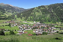
Dorfgastein
 | |||
| |||
| Państwo | |||
|---|---|---|---|
| Kraj związkowy | |||
| Powiat | St. Johann im Pongau | ||
| Powierzchnia | 54,13 km² | ||
| Wysokość | 812 m n.p.m. | ||
| Populacja (1 stycznia 2015) • liczba ludności | 1651 | ||
| • gęstość | 31 os./km² | ||
| Numer kierunkowy | 06433 | ||
| Kod pocztowy | 5632 | ||
| Tablice rejestracyjne | JO | ||
| Strona internetowa | |||
Dorfgastein – gmina w Austrii, w kraju związkowym Salzburg, w powiecie St. Johann im Pongau. Według Austriackiego Urzędu Statystycznego liczyła 1651 mieszkańców (1 stycznia 2015)[1].
Przypisy
Media użyte na tej stronie
Autor: Lencer, Licencja: CC BY-SA 3.0
Location map of Austria
Equirectangular projection, N/S stretching 150 %. Geographic limits of the map:
- N: 49.2° N
- S: 46.3° N
- W: 9.4° E
- E: 17.2° E
Autor: Rosso Robot, versions later 2013-10: NordNordWest, Licencja: CC BY-SA 3.0
Location map of Salzburg
Equirectangular projection. Geographic limits of the map:
- N: 48.0767055° N
- S: 46.8998111° N
- W: 12.0100138° E
- E: 14.0424444° E
Autor: Bwag, Licencja: CC BY-SA 4.0
Westansicht des Ortszentrums der Salzburger Gemeinde Dorfgastein.
Blazon: „Gules, enté en point Or charged with a torteaux accompanied by two bezants.“ The arms were officially granted on May 21, 1952. The arms is derived from the arms of the Lords von Goldegg, who built the local Klammstein Castle in the 13th century. The three roundels are taken from the arms of the Nonnberg Convent, to which the village of Unterberg in the municipality belonged for a long period of time.


