Dorking
| ||
(c) Ian Capper, CC BY-SA 2.0 | ||
| Państwo | ||
| Kraj | ||
| Region | South East England | |
| Hrabstwo | Surrey | |
| Populacja • liczba ludności | 17 000 | |
| Nr kierunkowy | 01306 | |
| Kod pocztowy | 01306 | |
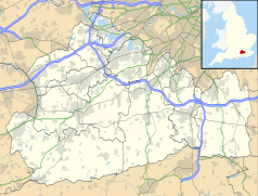
Położenie na mapie Surrey Contains Ordnance Survey data © Crown copyright and database right, CC BY-SA 3.0 | ||
| Portal | ||
Dorking – miasto w Wielkiej Brytanii, w Anglii, w regionie South East England, w hrabstwie Surrey, położone nad rzeką Mole. W 2001 r. miasto to zamieszkiwało 17 000 osób.
Miejsce śmierci Mariana Hemara.
Miasta partnerskie
Media użyte na tej stronie
Contains Ordnance Survey data © Crown copyright and database right, CC BY-SA 3.0
Map of Surrey, UK with the following information shown:
- Administrative borders
- Coastline, lakes and rivers
- Roads and railways
- Urban areas
Equirectangular map projection on WGS 84 datum, with N/S stretched 160%
Geographic limits:
- West: 0.87W
- East: 0.08E
- North: 51.50N
- South: 51.05N
Flag of England. Saint George's cross (a red cross on a white background), used as the Flag of England, the Italian city of Genoa and various other places.
Autor: Detraymond, Licencja: CC BY-SA 3.0
Eastern view from High Street in Dorking, Surrey, UK.
(c) Ian Capper, CC BY-SA 2.0
Dorking Viewed from Denbies Hillside. Prominent is the spire of St Martin's Church.
Autor: NordNordWest, Licencja: CC BY-SA 3.0
Location map of the United Kingdom


