Dorset
| Hrabstwo ceremonialne | |||||
 Plaża w Weymouth, w południowej części hrabstwa | |||||
| |||||
| Państwo | |||||
|---|---|---|---|---|---|
| Kraj | |||||
| Region | |||||
| Siedziba | |||||
| Powierzchnia | 2653 km² | ||||
| Populacja (2011) • liczba ludności |
| ||||
| • gęstość | 280,4 os./km² | ||||
| Szczegółowy podział administracyjny | |||||
 | |||||
| Liczba unitary authorities | 2 | ||||
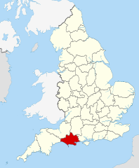
Położenie na mapie | |||||
| Strona internetowa | |||||
| Portal | |||||
Dorset – hrabstwo ceremonialne i historyczne w południowej Anglii, w regionie South West England, położone nad kanałem La Manche, obejmujące dwie jednostki administracyjne typu unitary authority – Dorset oraz Bournemouth, Christchurch and Poole. Do 2019 roku Dorset pełniło funkcję hrabstwa administracyjnego (niemetropolitalnego)[1], ze stolicą w Dorchester[2].
Hrabstwo liczy 2653 km² powierzchni i zamieszkane jest przez 744 000 osób (2011)[3].
We wschodniej części hrabstwa znajduje się główny ośrodek miejski – aglomeracja miast Bournemouth, Poole i Christchurch, podczas gdy pozostała część Dorsetu ma charakter wiejski. Turystyka odgrywa znaczącą rolę w gospodarce, szczególnie w nadmorskich miastach Bournemouth, Poole oraz Weymouth. Znaczna część wybrzeża, tzw. Jurassic Coast, wpisana została na listę światowego dziedzictwa UNESCO[2].
Na zachodzie Dorset graniczy z hrabstwem Devon, na północnym zachodzie z Somersetem, na północnym wschodzie z Wiltshire, a na wschodzie z Hampshire[2].
Podział administracyjny
1 kwietnia 2019 roku hrabstwo Dorset przestało pełnić funkcje administracyjne. W skład hrabstwa ceremonialnego wchodzą od tego czasu dwa dystrykty typu unitary authority[4]:
Do 2019
Wcześniej jako hrabstwo niemetropolitalne Dorset posiadało radę hrabstwa i dzieliło się na sześć dystryktów. W granicach hrabstwa ceremonialnego znajdowały się dodatkowo dwa dystrykty typu unitary authority:
- Weymouth and Portland
- West Dorset
- North Dorset
- Purbeck
- East Dorset
- Christchurch
- Bournemouth (unitary authority)
- Poole (unitary authority)
Mapa
Przypisy
- ↑ Article 8: County of Dorset, Dorset County Council and councillors of that Council, [w:] The Bournemouth, Dorset and Poole (Structural Changes) Order 2018, legislation.gov.uk (ang.).
- ↑ a b c Dorset, [w:] Encyclopædia Britannica [online] [dostęp 2011-09-05] (ang.).
- ↑ Table P04 2011 Census: Usual resident population by five-year age group, local authorities in England and Wales. Office for National Statistics. [dostęp 2012-07-18]. (ang.).
- ↑ About us. Dorset Council. [dostęp 2019-05-04]. (ang.).
- ↑ Office for National Statistics: KS101EW - Usual resident population. [w:] 2011 Census [on-line]. Nomis – Official labour market statistics, 2013-02-12. [dostęp 2022-06-05]. (ang.).
- ↑ Office for National Statistics: Built-up Area to Local Authority District (December 2011) Lookup in England and Wales. [w:] Open Geography Portal [on-line]. [dostęp 2022-06-05]. (ang.).
- ↑ Office for National Statistics: Built-up Area Sub Divisions (December 2011) Boundaries. [w:] Open Geography Potal [on-line]. [dostęp 2022-06-05]. (ang.).
Media użyte na tej stronie
Flag of England. Saint George's cross (a red cross on a white background), used as the Flag of England, the Italian city of Genoa and various other places.
The flag of Dorset, England.
Autor: Rcsprinter123, Licencja: CC BY 3.0
Numbered districts of Dorset county. Derived from File:Dorset UK district map (blank).svg, Nilfanion.
Contains Ordnance Survey data © Crown copyright and database right, CC BY-SA 3.0
Map of Dorset, UK with the following information shown:
- Administrative borders
- Coastline, lakes and rivers
- Roads and railways
- Urban areas
Equirectangular map projection on WGS 84 datum, with N/S stretched 155%
Geographic limits:
- West: 2.99W
- East: 1.65W
- North: 51.10N
- South: 50.50N
Autor: Nilfanion, Licencja: CC BY-SA 3.0
Location of the ceremonial county of Dorset within England.
Autor: Rcsprinter123, Licencja: CC BY 3.0
Numbered districts of Dorset ceremonial county (1974-2019). Derived from File:Dorset UK district map (blank).svg, by Nilfanion.
- Weymouth and Portland
- West Dorset
- North Dorset
- Purbeck
- East Dorset
- Christchurch
- Bournemouth
- Poole


