Dover (dystrykt)
| Dystrykt niemetropolitalny | |||
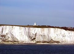
 Białe klify Dover | |||
| |||
| Państwo | |||
|---|---|---|---|
| Kraj | |||
| Hrabstwo | |||
| Siedziba | |||
| Powierzchnia | 314,84 km² | ||
| Populacja (2011) • liczba ludności |
| ||
| • gęstość | 355 os./km² | ||
| Położenie na mapie hrabstwa Kent Contains Ordnance Survey data © Crown copyright and database right, CC BY-SA 3.0 | |||
| Strona internetowa | |||
| Portal | |||
Dover District – dystrykt w Anglii, we wschodniej części hrabstwa Kent. Centrum administracyjne dystryktu znajduje się w Dover.
Dystrykt ma powierzchnię 314,84 km2, leży nad kanałem La Manche, zaś od północy graniczy z dystryktem Thanet, od zachodu z dystryktem Canterbury, od południa z dystryktem Folkestone and Hythe w hrabstwie Kent. Zamieszkuje go 111 674 osób.
Na terenie dystryktu znajduje się pochodzący z XII wieku zamek Dover[2] oraz pochodzące z XVI wieku zamki Walmer Castle [3] i Deal Castle[4]. W Richborough znajdują się ruiny rzymskiego fortu z II wieku[5].
W Dover mieści się jedno z najstarszych muzeów w hrabstwie Kent - założone w 1836 roku Dover Museum[6].
Podział administracyjny
Dystrykt obejmuje miasta Deal, Dover i Sandwich oraz 32 civil parish:
|
|
Dystrykt dzieli się na 21 okręgów wyborczych[7]:
|
|
Demografia
W 2011 roku dystrykt Dover miał 111 674 mieszkańców. Zgodnie ze spisem powszechnym z 2011 roku dystrykt zamieszkiwało 493 osoby urodzone w Polsce[8].
Podział mieszkańców według grup etnicznych na podstawie spisu powszechnego z 2011 roku[9].
|
|
Podział mieszkańców według wyznania na podstawie spisu powszechnego z 2011 roku[10].
- Chrześcijaństwo - 64,1%
- Islam – 0,5%
- Hinduizm – 0,6%
- Judaizm – 0,1%
- Buddyzm – 0,5%
- Sikhizm – 0,0%
- Pozostałe religie – 0,5%
- Bez religii – 26,0%
- Nie podana religia – 7,8%
Transport i komunikacja
Między Dover a Calais i Dunkierką działa regularna żegluga promowa.
Na terenie dystryktu znajdują się stacje Deal, Dover Priory i Sandwich które obsługują linie kolei dużej prędkości High Speed 1, na której jeżdżą pociągi Southeastern Highspeed, z tą różnicą, że poruszają się tutaj zwykłymi torami i dopiero na stacji Ashford International w dystrykcie Ashford wjeżdżają na linię High Speed.
Pozostałe stacje kolejowe:
- Aylesham
- Kearsney
- Martin Mill
- Shepherds Well
- Snowdown
- Walmer
W Dover swój początek mają drogi A2 i A20 które prowadzą do centrum Londynu, a także droga A256 która prowadzi w okolice Portu lotniczego Kent International w dystrykcie Thanet.
Inne miejscowości
Alkham, Ash, Ashley, Aylesham, Barnsole, Betteshanger, Buttsole, Capel-le-Ferne, Chillenden, Church Whitfield, Coldred, Coombe, Denton, Drellingore, East Langdon, East Studdal, Eastry, Elmstone, Elvington, Ewell Minnis, Eythorne, Farthingloe, Finglesham, Frogham, Goodnestone, Great Mongeham, Guston, Hacklinge, Hoaden, Hougham, Kearsney, Kingsdown, Langdon, Little Mongeham, Lydden, Marley, Marshborough, Martin Mill, Martin, Maxton, Nonington, Northbourne, Preston, Richborough, Ringwould, Ripple, River, St Margaret-at-Cliffe, Shepherdswell, Sholden, Snowdown, Staple, Stourmouth, Sutton, Swingate, Temple Ewell, Tilmanstone, Waldershare, Ware, West Langdon, West Studdal, Westcliffe, Westmarsh, Whitfield, Wingham, Woodnesborough, Wootton, Worth.
Przypisy
- ↑ „ons.gov.uk – 2011 Census: KS102EW Age structure, local authorities in England and Wales”
- ↑ „english-heritage.org.uk – Dover Castle”
- ↑ „english-heritage.org.uk – Walmer Castle and gardens”
- ↑ „english-heritage.org.uk – Deal Castle”
- ↑ „english-heritage.org.uk – Richborough roman fort and amphitheatre”
- ↑ „dovermuseum.co.uk – Official site”
- ↑ „ moderngov.dover.gov.uk - Your Councillors by Ward”
- ↑ „ons.gov.uk – 2011 Census: KS204EW Country of birth, local authorities in England and Wales”
- ↑ „ons.gov.uk – 2011 Census: KS201EW Ethnic group, local authorities in England and Wales”
- ↑ „ons.gov.uk – 2011 Census: KS209EW Religion, local authorities in England and Wales”
Media użyte na tej stronie
Flag of England. Saint George's cross (a red cross on a white background), used as the Flag of England, the Italian city of Genoa and various other places.
Contains Ordnance Survey data © Crown copyright and database right, CC BY-SA 3.0
Equirectangular map projection on WGS 84 datum, with N/S stretched 160%
Autor: M Packwood Ace, Licencja: CC BY-SA 3.0
Artillery castle at Walmer
Autor: Clem Rutter, Rochester, Kent, Licencja: CC BY 3.0
Langdon Cliffs rise 120 m, the lie to the east of Dover, heading to South Foreland. A spur directly above thePort of Dover, at the entrance to the White Cliffs Visitors Centre gives views over port and the eastern facade of Dover Castle. P&O Spirit of Britain P&O Pride of Canterbury
DFDS Dover SeawaysAutor: Lieven Smits, Licencja: CC BY-SA 3.0
Aerial view of Deal Castle on the East coast of Kent (England). Nikon D60 f=85mm f/9 at 1/1250s ISO 800. Processed using Nikon ViewNX 1.5.2 and GIMP 2.6.6.


