Downey (Kalifornia)
 | |||||
| Państwo | |||||
|---|---|---|---|---|---|
| Stan | |||||
| Hrabstwo | Los Angeles | ||||
| Burmistrz | Rick Trejo | ||||
| Powierzchnia | 32,6 km² | ||||
| Wysokość | 36 m n.p.m. | ||||
| Populacja (2000) • liczba ludności • gęstość | 107 323 3336 os./km² | ||||
| Nr kierunkowy | 562 | ||||
| Kod pocztowy | 90239-90242 | ||||
Położenie na mapie Kalifornii  | |||||
Położenie na mapie Stanów Zjednoczonych  | |||||
| Strona internetowa | |||||
| Portal | |||||
Downey – miasto w hrabstwie Los Angeles, w stanie Kalifornia (USA). W roku 2000 liczyło 107 323 mieszkańców.
Zdjęcia
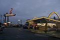
McDonald’s przy Lakewood Blvd i Florence Ave
Sławni ludzie związani z miastem
- James Hetfield – muzyk Metallica
- Karen Carpenter – muzyk The Carpenters
- Richard Carpenter – muzyk The Carpenters
Linki zewnętrzne
| Hrabstwa | |
|---|---|
| Główne miasto ma 3,99 milionów mieszkańców | |
| Miasta mające ponad 250 tys. mieszkańców | |
| Miasta mające od 100 do 250 tysięcy mieszkańców | |
| Zbiorniki wodne |
|
| Regiony |
|

- Portal:Wielkie Los Angeles
- Wikiprojekt:Kalifornia
Kontrola autorytatywna (miasto w Stanach Zjednoczonych):
Media użyte na tej stronie
USA California location map.svg
Autor: NordNordWest, Licencja: CC BY 3.0
Location map of California, USA
Autor: NordNordWest, Licencja: CC BY 3.0
Location map of California, USA
Usa edcp location map.svg
Autor: Uwe Dedering, Licencja: CC BY-SA 3.0
Location map of the USA (without Hawaii and Alaska).
Autor: Uwe Dedering, Licencja: CC BY-SA 3.0
Location map of the USA (without Hawaii and Alaska).
EquiDistantConicProjection:
Central parallel:
* N: 37.0° N
Central meridian:
* E: 96.0° W
Standard parallels:
* 1: 32.0° N
* 2: 42.0° N
Made with Natural Earth. Free vector and raster map data @ naturalearthdata.com.
Formulas for x and y:
x = 50.0 + 124.03149777329222 * ((1.9694462586094064-({{{2}}}* pi / 180))
      * sin(0.6010514667026994 * ({{{3}}} + 96) * pi / 180))
y = 50.0 + 1.6155950752393982 * 124.03149777329222 * 0.02613325650382181
      - 1.6155950752393982  * 124.03149777329222 *
     (1.3236744353715044  - (1.9694462586094064-({{{2}}}* pi / 180))
      * cos(0.6010514667026994 * ({{{3}}} + 96) * pi / 180))

Flag of the United States.svg
The flag of Navassa Island is simply the United States flag. It does not have a "local" flag or "unofficial" flag; it is an uninhabited island. The version with a profile view was based on Flags of the World and as a fictional design has no status warranting a place on any Wiki. It was made up by a random person with no connection to the island, it has never flown on the island, and it has never received any sort of recognition or validation by any authority. The person quoted on that page has no authority to bestow a flag, "unofficial" or otherwise, on the island.
The flag of Navassa Island is simply the United States flag. It does not have a "local" flag or "unofficial" flag; it is an uninhabited island. The version with a profile view was based on Flags of the World and as a fictional design has no status warranting a place on any Wiki. It was made up by a random person with no connection to the island, it has never flown on the island, and it has never received any sort of recognition or validation by any authority. The person quoted on that page has no authority to bestow a flag, "unofficial" or otherwise, on the island.
Downey City Hall.jpg
Personal Photo of Downey's City Hall built in 1984 and located in the Downey Civic Center on Brookshire Avenue and 2nd street. Released to the public domain.
Personal Photo of Downey's City Hall built in 1984 and located in the Downey Civic Center on Brookshire Avenue and 2nd street. Released to the public domain.

Flag of Downey, California.svg
Flag of Downey
Flag of Downey
Los Angeles Basin JPLLandsat.jpg
3-D Perspective image of the Los Angeles Basin from the Landsat satellite using NASA's Shuttle Radar Topography Mission (SRTM) for topography information. The vertical scale is exaggerated one and half times.
3-D Perspective image of the Los Angeles Basin from the Landsat satellite using NASA's Shuttle Radar Topography Mission (SRTM) for topography information. The vertical scale is exaggerated one and half times.

Flag of California.svg
Flag of California. This version is designed to accurately depict the standard print of the bear as well as adhere to the official flag code regarding the size, position and proportion of the bear, the colors of the flag, and the position and size of the star.
Flag of California. This version is designed to accurately depict the standard print of the bear as well as adhere to the official flag code regarding the size, position and proportion of the bear, the colors of the flag, and the position and size of the star.

Seal of Downey, California.svg
Seal of Downey, California
Seal of Downey, California

DowneyMcdonalds.jpg
Autor: Photo by Bryan Hong (Brybry26), Licencja: CC BY-SA 2.5
Najstarsza działająca restauracja sieci McDonald's i trzecia najstarsza pod względem daty budowy, otwarta w 1953 r. Mieści się przy 10207 Lakewood Blvd. na Florence Ave. w Downey, w stanie Kalifornia.
Autor: Photo by Bryan Hong (Brybry26), Licencja: CC BY-SA 2.5
Najstarsza działająca restauracja sieci McDonald's i trzecia najstarsza pod względem daty budowy, otwarta w 1953 r. Mieści się przy 10207 Lakewood Blvd. na Florence Ave. w Downey, w stanie Kalifornia.