Downtown Los Angeles
| ||||
| ||||
Skyline Downtown Los Angeles widziane z Obserwatiorium Griffitha w październiku 2006 | ||||
| ||||
| Państwo | ||||
| Stan | ||||
| Miasto | Los Angeles | |||
| Powierzchnia | 8,538 km² | |||
| Populacja • liczba ludności | 45 518 | |||
| • gęstość | 8580 os./km² | |||
| Strefa numeracyjna | (+48) 61 | |||
Plan Downtown Los Angeles | ||||
Położenie na mapie metropolii Los Angeles  | ||||
Położenie na mapie Stanów Zjednoczonych  | ||||
Położenie na mapie Kalifornii  | ||||
| 34°03′25″N 118°14′17″W/34,057000 -118,238000 | ||||
| Portal | ||||
Downtown Los Angeles (pol. Śródmieście Los Angeles) – główna dzielnica biznesowa położona w środkowej części Los Angeles, w stanie Kalifornia, leżąca w geograficznym środku obszaru metropolitalnego Los Angeles. W tej okolicy mieści się wiele instytucji artystycznych i sportowych, różnorodnych wieżowców, siedzib międzynarodowych korporacji, galerii sztuki i unikatowych sklepów. Downtown Los Angeles stanowi centrum sieci miejskich autostrad i systemu metra w Los Angeles. Za Downtown Los Angeles uważany jest zwykle obszar ograniczony od wschodu rzeką Los Angeles i dzielnicą Lincoln Heights, od północy przez Hollywood (Route 101) Freeway i Santa Monica (I-10) Freeway oraz Harbor (SR-110) Freeway na zachodzie, niektóre źródła w tym Los Angeles Downtown News i Los Angeles Times[1], podają informacje według których obszar Downtown Los Angeles ma być rozszerzony o University Park i Exposition Park i obejmować University of Southern California (USC) i dzielnice Central City West.
Galeria

Angels Flight w listopadzie 2008 roku
 (c) Photo taken by Nick Grasu., CC BY-SA 3.0
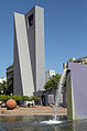
University of Southern California (USC)
 (c) kkmd, CC-BY-SA-3.0
Katedra Matki Bożej Anielskiej mieści się blisko Los Angeles City Hall

Orpheum Theatre w roku 2007
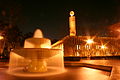
Fontanna na Pershing Square
Zobacz też
Przypisy
- ↑ Los Angeles Times - We are currently unavailable in your region, www.latimes.com [dostęp 2018-05-25] [zarchiwizowane z adresu 2008-10-07].
Linki zewnętrzne
| Tematy |
|
|---|---|
| Władze |
|
| Rejony |
|

- Portal:Wielkie Los Angeles
- Wikiprojekt:Kalifornia
| Dzielnice i osiedla | |
|---|---|
| Ciekawe miejsca |
|
_edit1.jpg)
- Downtown
- Northeast/Eastside
- Harbor Area
- Greater Hollywood
- Westlake/Silver Lake/Los Feliz
- San Fernando Valley
- South Los Angeles
- Westside
- Wilshire
- Portal:Wielkie Los Angeles
- Wikiprojekt:Kalifornia
Media użyte na tej stronie
Autor: Alexrk2, Licencja: CC BY 3.0
Ta mapa została stworzona za pomocą GeoTools.
Autor: Uwe Dedering, Licencja: CC BY-SA 3.0
Location map of the USA (without Hawaii and Alaska).
EquiDistantConicProjection:
Central parallel:
* N: 37.0° N
Central meridian:
* E: 96.0° W
Standard parallels:
* 1: 32.0° N
* 2: 42.0° N
Made with Natural Earth. Free vector and raster map data @ naturalearthdata.com.
Formulas for x and y:
x = 50.0 + 124.03149777329222 * ((1.9694462586094064-({{{2}}}* pi / 180))
      * sin(0.6010514667026994 * ({{{3}}} + 96) * pi / 180))
y = 50.0 + 1.6155950752393982 * 124.03149777329222 * 0.02613325650382181
      - 1.6155950752393982  * 124.03149777329222 *
     (1.3236744353715044  - (1.9694462586094064-({{{2}}}* pi / 180))
      * cos(0.6010514667026994 * ({{{3}}} + 96) * pi / 180))
Autor: NordNordWest, Licencja: CC BY 3.0
Location map of California, USA

The flag of Navassa Island is simply the United States flag. It does not have a "local" flag or "unofficial" flag; it is an uninhabited island. The version with a profile view was based on Flags of the World and as a fictional design has no status warranting a place on any Wiki. It was made up by a random person with no connection to the island, it has never flown on the island, and it has never received any sort of recognition or validation by any authority. The person quoted on that page has no authority to bestow a flag, "unofficial" or otherwise, on the island.

Flag of California. This version is designed to accurately depict the standard print of the bear as well as adhere to the official flag code regarding the size, position and proportion of the bear, the colors of the flag, and the position and size of the star.

(c) Photo taken by Nick Grasu., CC BY-SA 3.0
USC Campus. Fountain outside of Doheny Library, with the Von KleinSmid Center.

Autor: Matthew Field, http://www.photography.mattfield.com, Licencja: CC BY 2.5
Panorama of downtown Los Angeles at sunset
Autor: Brion VIBBER, Licencja: CC-BY-SA-3.0
West facade of the Los Angeles City Hall — in Downtown Los Angeles, California.
- In process of seismic upgrading, this 1928 high-rise building was placed atop a mechanical system of isolators, sliders, and dampers called "base isolation technology".
- It is the tallest base-isolated structure in the world.

Autor: Alossix, Licencja: CC BY 3.0
Union Station in Downtown Los Angeles

(c) kkmd, CC-BY-SA-3.0
The Cathedral of Our Lady of the Angels — entry courtyard with fountain, in Downtown Los Angeles, California.
- Base isolation was used for earthquake engineering—seismic fitness of the cathedral.

Autor: jjron, Licencja: GFDL 1.2
The Pershing Square fountain and bell tower. Los Angeles, California, USA.

Autor: Alossix, Licencja: CC BY 3.0
Historic Angels Flight Funicular Railway in Downtown Los Angeles in 2008

An approximation of the seal of Los Angeles, California. On March 27, 1905 Ordinance 10,834 authorized and described the City Seal still being used today.[1].

Autor: Justin, Licencja: CC BY 2.0
The Orpheum Theatre marquee on Broadway in downtown Los Angeles
Map of the Greater Los Angeles Freeway system - with Downtown Los Angeles at its center.