Droga A601(M)
| Data otwarcia | 1960[1] | ||||||||||||||||||||||||||||||||||||||||||||||||||||||||||||||||||||||||||||||||||||||||||||||||||||||||||||||||||||||||||||||||||||||||||
| Długość | 1,2 mil / 2[2] km | ||||||||||||||||||||||||||||||||||||||||||||||||||||||||||||||||||||||||||||||||||||||||||||||||||||||||||||||||||||||||||||||||||||||||||
| Hrabstwa | Lancashire | ||||||||||||||||||||||||||||||||||||||||||||||||||||||||||||||||||||||||||||||||||||||||||||||||||||||||||||||||||||||||||||||||||||||||||
| Zdjęcie | |||||||||||||||||||||||||||||||||||||||||||||||||||||||||||||||||||||||||||||||||||||||||||||||||||||||||||||||||||||||||||||||||||||||||||
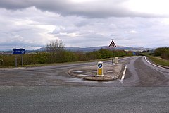
(c) Ian Capper, CC BY-SA 2.0 Południowy koniec A601(M) | |||||||||||||||||||||||||||||||||||||||||||||||||||||||||||||||||||||||||||||||||||||||||||||||||||||||||||||||||||||||||||||||||||||||||||
| |||||||||||||||||||||||||||||||||||||||||||||||||||||||||||||||||||||||||||||||||||||||||||||||||||||||||||||||||||||||||||||||||||||||||||
Droga A601(M), autostrada A601(M) (ang. A601(M) motorway) – brytyjska autostrada znajdującą się w hrabstwie Lancashire. Droga ma długość 2 km (1,2 mili) i składa się z dwóch odcinków o różnym przekroju: odcinek łączący autostradę M6 z drogą A6 jest dwujezdniowy, zaś na południe od węzła z M6 składa się z jednej dwupasowej jezdni, która po kilkuset metrach[3] kończy się jednopoziomowym węzłem z drogą B6254.
Numer drogi może sugerować, że trasa stanowi posiadającą parametry autostrady drogę A601 (analogicznie do innych dróg numerowanych jako Ax(M)), jednakże tak nie jest – w rzeczywistości brytyjska arteria A601 znajduje się ponad 160 kilometrów (100 mil) dalej, w miejscowości Derby.
Historia
Odcinek pomiędzy M6 a węzłem 35A otwarto w 1960 roku[1], jako część obwodnicy Lancaster[4]. Była to dwupasowa autostrada. W 1970 roku[4] przedłużono M6 na północ, zaś krótką odnogę pozostawiono jako łącznik z drogą A6. Rondo na końcu drogi oznaczono jako węzeł 35A. Istniały plany przedłużenia trasy jako łącznik Arnside, przebiegający przez Furness Peninsula do M6, jednakże nie doszło do ich realizacji ze względów środowiskowych. Ślad niedoszłej trasy obecnie pokrywa się częściowo z drogą A590.
W 1987 roku[3] zbudowano połączenie z drogą B6254 w celu przeniesienia z Carnforth ruchu tranzytowego zmierzającego do Over Kellet Quarries i Kirkby Lonsdale. Wtedy droga została przenumerowana na A601(M). To zakończenie autostrady nie otrzymało numeru węzła.
Węzły
| Droga A601(M) | ||
| Wyjazd w kierunku południowym | Węzeł | Wyjazd w kierunku północnym |
| Carnforth, Over Kellet, Kirkby Lonsdale B6254 | Zakończenie | Początek autostrady |
| Lake District, Carlisle, Kendal, Barrow-in-Furness, Lancaster, Preston, THE SOUTH M6 | J35 | Lake District, Carlisle, Kendal, Barrow-in-Furness, Lancaster, Preston, THE SOUTH M6 |
| Początek autostrady | J35a Zakończenie | Milnthorpe, Kendal, Morecambe, Carnforth A6 |
Zobacz też
Uwagi
- ↑ Węzeł bezkolizyjny jedynie dla autostrady M6, jadąc A601(M) wjeżdża się na rondo. Zobacz na OpenStreetMap
Przypisy
- ↑ a b The Motorway Archive The Lancaster by-pass section of M6 and the Carnforth link roads A601(M) (ang.). [dostęp 2017-01-23]. [zarchiwizowane z tego adresu (2006-11-01)].
- ↑ Pathetic Motorways (ang.). [dostęp 2017-01-23].
- ↑ a b Chris Marshall: CBRD » Motorway Database » A601(M) (ang.). [dostęp 2017-01-23].
- ↑ a b Route 6 -The A6 ad M6 Website (ang.). [dostęp 2017-01-23].
Media użyte na tej stronie
Sign no. 392 - Customs, darker version
prom rzeka-icon.
(Motorway) tunnel Icon. Drawing similar to Swiss road signs.
Gas station symbol
AIGA Air Transportation sign (inverted)
Autor: https://phabricator.wikimedia.org/diffusion/GOJU/browse/master/AUTHORS.txt, Licencja: MIT
An icon from the OOjs UI MediaWiki lib.
Autor: https://phabricator.wikimedia.org/diffusion/GOJU/browse/master/AUTHORS.txt, Licencja: MIT
An icon from the OOjs UI MediaWiki lib.
Symbol used for motorways in the United Kingdom.
Motorway badge for the A601 (M) motorway
(c) Ian Capper, CC BY-SA 2.0
The start of the A601(M) The A601(M) has two parts - the part west of Junction 35 with the M6 is a dual carriageway link to the A6, and once formed the northern end of the M6 until the main motorway was extended northwards. But the eastern part was added in 1987 to enable lorries from the quarries to the south to join the M6 without having to go through Carnforth. Its potential usage didn't justify a full blown dual carriageway, but because it gave nowhere to go for non-motorway traffic, it had to be designated a motorway. The result: a stretch of single carriageway motorway, with two way traffic, which ends at a T junction with a B road (the B6254), as shown here! Note the motorway and two way traffic signs. Not as impressive in length as what was the A6144(M) in Greater Manchester (SJ7793), which is also single carriageway but alas is now no longer a motorway, despite what the map for the square still shows (and unfortunately there are no photos of it on Geograph), but the A601(M) is still a worthy feature of the UK road network. In particular, being a motorway without speed limit indications, it presumably has a 70mph speed limit - one of the few places in the country where one can legally travel at 70mph on a non-dual carriageway, not that the stretch of road is really long enough to allow it!


