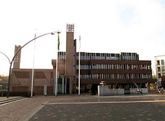
Dronten
| |||||
 Centrum Dronten | |||||
| |||||
| Państwo | |||||
| Prowincja | |||||
| Gmina | Dronten | ||||
| Burmistrz | Aat de Jonge (2014)[1] | ||||
| Powierzchnia | 423,89 km² | ||||
| Populacja (2013) • liczba ludności • gęstość | 40 637 122 os./km² | ||||
| Nr kierunkowy | 0321 | ||||
| Kod pocztowy | 8250-8259 | ||||
 | |||||
| Strona internetowa | |||||
Dronten − miasto i gmina w środkowej Holandii (prowincja Flevoland). Według spisu ludności z 2013 gminę zamieszkuje 40 637 osób, a sama miejscowość Dronten 27 871 mieszkańców. Gmina ma powierzchnię 423,89 km², a gęstość zaludnienia wynosi tu 122 os./km².
Przypisy
- ↑ dronten.nl: College van Dronten (niderl.). [dostęp 2014-07-10].
Bibliografia
- dronten.nl (niderl.)
| ||||||
| ||||||||||||||||
Media użyte na tej stronie
Autor: Erik Frohne, Licencja: CC BY-SA 3.0
Location map of province Flevoland in the Netherlands
Equirectangular projection, N/S stretching 165 %. Geographic limits of the map:
- N: 52.90° N
- S: 52.20° N
- W: 5.00° E
- E: 6.10° E
Autor: Janwillemvanaalst, Licencja: CC BY-SA 3.0
Topografische kaart van gemeente Dronten (2013).
Samengesteld door Jan-Willem van Aalst op basis van de GML open geodata van de BRT/Top10NL (basisregistratie Topografie, Kadaster 2011), vrijgegeven door Kadaster onder de Creative Commons BY licentie. Additionele gegevens uit BAG (8 juli 2013), uit de Open Street Map (9 juli 2013) en uit de Risicokaart. Peildatum kaartbeeld: 9 juli 2013. Zie ook Gemeentenatlas.nl
Samenstelling en kleurenschema: Jan-Willem van Aalst, met QuantumGIS en Photoshop. Zie ook de Legenda.Flag of the Dutch municipality of Dronten


