Duluth (Minnesota)
 | |||
| |||
| Państwo | |||
|---|---|---|---|
| Stan | |||
| Hrabstwo | |||
| Burmistrz | Emily Larson↗ | ||
| Populacja (2019) • liczba ludności |
| ||
| Nr kierunkowy | 218 | ||
| Kod pocztowy | 55801, 55802, 55803, 55804, 55805, 55806, 55807, 55808, 55810, 55811, 55812 | ||
| Strefa czasowa | |||
| Strona internetowa | |||
| Portal | |||
Duluth – (wym. ang. [dəˈluːθ]) miasto w północnej części kontynentalnych Stanów Zjednoczonych, w stanie Minnesota. Ważny port śródlądowy i morski nad Jeziorem Górnym, połączony z Atlantykiem Drogą Wodną Świętego Wawrzyńca.
Miasto liczy 85,6 tys. mieszkańców (dane z 2019), a jego obszar metropolitalny 291,3 tys. mieszkańców (dane z 2000).
Największą atrakcją turystyczną Duluth jest Aerial Lift Bridge, czyli most działający na zasadzie windy: kiedy statek przepływa, dolna część mostu podnoszona jest do góry.
W mieście rozwinął się przemysł rafineryjny, spożywczy, stoczniowy, maszynowy oraz hutniczy[2].
Od 1947 w mieście działa uniwersytet[2].
Znane osoby związane z miastem
- Mason Aguirre – olimpijczyk (snowboarding)
- Berard Józef Bulsiewicz – kapłan, misjonarz, powstaniec styczniowy.
- Maria Bamford – aktorka
- Carol Bly – pisarka, żona Roberta Blya
- Bill Berry perkusista R.E.M.
- Thomas Bujack - Potentat kolejowy
- Bob Dylan – piosenkarz, kompozytor i autor tekstów
- Tyler George - mistrz olimpijski w curlingu
- Roger Grimsby – dziennikarz, dziennikarz TV, aktor
- Stanisław Iciek - polski duchowny
- Scott Jurek – ultramaratończyk
- Lenny Lane – zawodowy wrestler
- Bill Irwin ("The Goon") – zawodowy wrestler
- Dorothy Arnold (Olson) – aktorka, pierwsza żona baseballisty Joe DiMaggio
- David Oreck – biznesmen
- Don LaFontaine – udziela swojego głosu w reklamowych zapowiedziach filmów, reklamach TV, promocjach i grach wideo
- Lorenzo Music – aktor
- Jake Potocnik – wynalazca Ped Egg
- Charlie Parr – muzyk bluesowy
- Rick Rickert – gracz baseballowy w New Zealand Breakers
- Phil Solem – muzyk
- Alan Sparhawk i Mimi Parker – założyciele alternatywnej grupy rockowej Low
Miasta partnerskie
 Pietrozawodsk, Rosja
 Växjö, Szwecja
 Ohara, Japonia
 Thunder Bay, Kanada
Przypisy
- ↑ US Census Bureau.
- ↑ a b Duluth, [w:] Encyklopedia PWN [online] [dostęp 2021-10-14].
Media użyte na tej stronie
Autor: Uwe Dedering, Licencja: CC BY-SA 3.0
Location map of the USA (without Hawaii and Alaska).
EquiDistantConicProjection:
Central parallel:
* N: 37.0° N
Central meridian:
* E: 96.0° W
Standard parallels:
* 1: 32.0° N
* 2: 42.0° N
Made with Natural Earth. Free vector and raster map data @ naturalearthdata.com.
Formulas for x and y:
x = 50.0 + 124.03149777329222 * ((1.9694462586094064-({{{2}}}* pi / 180))
      * sin(0.6010514667026994 * ({{{3}}} + 96) * pi / 180))
y = 50.0 + 1.6155950752393982 * 124.03149777329222 * 0.02613325650382181
      - 1.6155950752393982  * 124.03149777329222 *
     (1.3236744353715044  - (1.9694462586094064-({{{2}}}* pi / 180))
      * cos(0.6010514667026994 * ({{{3}}} + 96) * pi / 180))
The flag of Navassa Island is simply the United States flag. It does not have a "local" flag or "unofficial" flag; it is an uninhabited island. The version with a profile view was based on Flags of the World and as a fictional design has no status warranting a place on any Wiki. It was made up by a random person with no connection to the island, it has never flown on the island, and it has never received any sort of recognition or validation by any authority. The person quoted on that page has no authority to bestow a flag, "unofficial" or otherwise, on the island.
Autor: Alexrk2, Licencja: CC BY 3.0
Ta mapa została stworzona za pomocą GeoTools.
Autor: Sletbte, Licencja: CC BY-SA 3.0
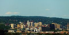
The Duluth, Minnesota skyline facing northwest
Flag of Duluth


