Dunblane
| ||
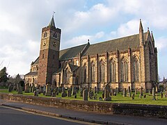
 Katedra Kościoła Szkocji w Dunblane | ||
| Państwo | ||
| Kraj | ||
| Hrabstwo | Stirling | |
| Populacja • liczba ludności | 10 000 | |
| Kod pocztowy | FK15 | |
Położenie na mapie hrabstwa Stirling Contains Ordnance Survey data © Crown copyright and database right, CC BY-SA 3.0 | ||
Położenie na mapie Wielkiej Brytanii (c) Karte: NordNordWest, Lizenz: Creative Commons by-sa-3.0 de | ||
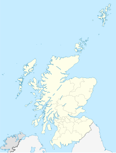
Położenie na mapie Szkocji | ||
| Portal | ||
Dunblane (gael. Dùn Bhlàthain) – miasto w Szkocji liczące około 10 tys. mieszkańców, którego historia sięga VII wieku. Jest położone kilka mil od Stirling w kierunku północnym. Zostało prawdopodobnie założone w 602 roku przez celtyckiego misjonarza (St Blane)[1].
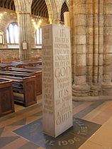
Główną atrakcją miejscowości jest gotycka Katedra Dunblane – jeden z niewielu zachowanych średniowiecznych kościołów w Szkocji[2]. W czasach współczesnych (13 marca 1996 roku) w szkole podstawowej doszło do masakry – szaleniec zastrzelił 16 małych dzieci i ich nauczycielkę[3] (zob. masakra w Dunblane). Dla uczczenia ofiar wewnątrz katedry ustawiono obelisk (rzeźbiarz: Richard Kindersley(ang.)[4]) z napisem:
IF THERE IS ANYTHING THAT WIL ENDURE THE EYE OF GOD
because it is pure
IT IS THE SPIRIT of A LITTLE CHILD
Na jednej z bocznych ścian obelisku umieszczono fragment wiersza Bayarda Taylora (The poet’s journal 1863):
But still I dream that some-where there must be the spirit of a child that waits for me.[5]
Angielski zespół Brutal Attack poświęcił masakrze w Dunblane piosenkę "The Angels Of Dunblane".
Przypisy
- ↑ Dunblane (ang.). W: Visit Scotland | ALBA [on-line]. VisitScotland.com. [dostęp 2017-06-18].
- ↑ Dunblane Cathedral (ang.). W: Strona internetowa Katedry [on-line]. [dostęp 2017-06-18].
- ↑ Mass shootings and gun control > Dunblane: 13 March 1996 (ang.). W: BBC News Services [on-line]. 2 June 2010. [dostęp 2018-06-03].
- ↑ Richard Kindersley (ang.). W: Strona internetowa artysty [on-line]. kindersleystudio.co.uk. [dostęp 2017-06-18].
- ↑ Bayard Taylor: Dreams Of A Child In Wait (ang.). W: Headstone Epitaph Examples [on-line]. RemembranceQuotes.com. [dostęp 2018-06-03].
Linki zewnętrzne
Media użyte na tej stronie
(c) Karte: NordNordWest, Lizenz: Creative Commons by-sa-3.0 de
Location map of the United Kingdom
Autor: PaddyBriggs, Licencja: CC BY-SA 3.0
The Standing Stone sculpted by Richard Kindersley to commemorate the events in Dunblane of 13th March 1996 - the Dunblane school massacre. Text on left is from The poet's journal by Bayard Taylor (page 80, published by Ticknor and Fields in 1863); text on right is from The Children's Prayer by Richard Henry Stoddard (born 1825, died 1903).
Contains Ordnance Survey data © Crown copyright and database right, CC BY-SA 3.0
Blank map of Stirling, UK with the following information shown:
- Administrative borders
- Coastline, lakes and rivers
- Roads and railways
- Urban areas
Equirectangular map projection on WGS 84 datum, with N/S stretched 175%
Geographic limits:
- West: 4.90W
- East: 3.76W
- North: 56.60N
- South: 55.93N
(c) Eric Gaba, NordNordWest, CC BY-SA 3.0
Location map of Scotland, United Kingdom


