Dunfermline
| Państwo | |
|---|---|
| Kraj | |
| Hrabstwo | Fife |
| Wysokość | 115 m n.p.m. |
| Populacja (2005) • liczba ludności |
|
| Nr kierunkowy | 01383 |
Położenie na mapie Fife  Contains Ordnance Survey data © Crown copyright and database right, CC BY-SA 3.0 | |
Położenie na mapie Wielkiej Brytanii  (c) Karte: NordNordWest, Lizenz: Creative Commons by-sa-3.0 de | |
Położenie na mapie Szkocji | |
| Strona internetowa | |
| Portal | |
Dunfermline (gael. Dùn Phàrlain) – miasto w Szkocji, w regionie Fife. Miasto usytuowane jest w pobliżu zatoki Firth of Forth na Morzu Północnym.
Miasto jest historyczną stolicą Szkocji. Robert I Bruce został pochowany w tutejszym opactwie Dunfermline Abbey założonym w 1070[2] roku. Jest otoczone od północy po południe doliną Pittencrieff. W 2005 r. miasto liczyło ok. 39 tys. mieszkańców.
Pochodzili stąd m.in. poeta Robert Henryson (zm. ok. 1500) oraz przemysłowiec Andrew Carnegie (zm. 1919). Tu został stworzony także zespół rockowy Nazareth, urodził się też tutaj Ian Anderson, lider rockowej grupy Jethro Tull.
W mieście rozwinął się przemysł włókienniczy, maszynowy oraz metalowy[1].
Galeria
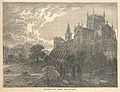
Opactwo Dunfermline, grafika z 1902 r.

Opactwo Dunfermline – główne wejście.
 (c) Paul McIlroy, CC BY-SA 2.0
Park Pittencrieff znany jako The Glen.

Miasta partnerskie
Zobacz też
- Dunfermline Town – stacja kolejowa
Przypisy
- ↑ a b Dunfermline, [w:] Encyklopedia PWN [online] [dostęp 2021-06-22].
- ↑ Praca zbiorowa: Sztuka Romańska. red. Rolf Toman. Tandem Verlag GmBH, 2008, s. 248. ISBN 978-83-7512-972-4.
- ↑ a b c d e f Town twinning, web.archive.org, 3 stycznia 2017 [dostęp 2022-01-25] [zarchiwizowane z adresu 2017-01-03].
- ↑ Internasjonalt arbeid, Trondheim kommune [dostęp 2022-01-25] (norw.).
Linki zewnętrzne
- Oficjalna strona miasta (ang.)
Media użyte na tej stronie
(c) Karte: NordNordWest, Lizenz: Creative Commons by-sa-3.0 de
Location map of the United Kingdom

(c) Eric Gaba, NordNordWest, CC BY-SA 3.0
Location map of Scotland, United Kingdom


Flag of Portugal, created by Columbano Bordalo Pinheiro (1857-1929), officially adopted by Portuguese government in June 30th 1911 (in use since about November 1910). Color shades matching the RGB values officially reccomended here. (PMS values should be used for direct ink or textile; CMYK for 4-color offset printing on paper; this is an image for screen display, RGB should be used.)

Autor: Pedro A. Gracia Fajardo, escudo de Manual de Imagen Institucional de la Administración General del Estado, Licencja: CC0
Flaga Hiszpanii

The flag of Navassa Island is simply the United States flag. It does not have a "local" flag or "unofficial" flag; it is an uninhabited island. The version with a profile view was based on Flags of the World and as a fictional design has no status warranting a place on any Wiki. It was made up by a random person with no connection to the island, it has never flown on the island, and it has never received any sort of recognition or validation by any authority. The person quoted on that page has no authority to bestow a flag, "unofficial" or otherwise, on the island.

.svg)


(c) Mcwesty z angielskiej Wikipedii, CC BY-SA 3.0
Various images of Dunfermline- Top: Dunfermline skyline. Middle left: Dunfermline High Street. Middle right: Dunfermline City Chambers. Bottom left- Carnegie Trust HQ Building, Pittencrieff Park. Bottom: Italian Garden, Pittencrieff Park.
Contains Ordnance Survey data © Crown copyright and database right, CC BY-SA 3.0
Blank map of Fife, UK with the following information shown:
- Administrative borders
- Coastline, lakes and rivers
- Roads and railways
- Urban areas
Equirectangular map projection on WGS 84 datum, with N/S stretched 175%
Geographic limits:
- West: 3.8W
- East: 2.5W
- North: 56.5N
- South: 55.9N

(c) Paul McIlroy, CC BY-SA 2.0
Pittencrieff Park, known locally as The Glen, was gifted to the people of Dunfermline by the millionaire and philanthropist Andrew Carnegie who was born in the town.

(c) Andy Stephenson, CC BY-SA 2.0
Dunfermline Abbey. Photo of the main entrance, taken on a fine winter evening from the entrance to the gardens.