Dystrykt Luizjany
| niezorganizowane terytorium inkorporowane | |
| 1804–1805 | |
| Państwo | |
|---|---|
| Siedziba | |
| Data powstania | |
| Data likwidacji | |
| Zarządzający | |
| Gubernator | |
| Języki urzędowe | |
Położenie na mapie | |
| Portal | |
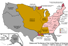
Dystrykt Luizjany (ang. District of Louisiana) − niezorganizowane terytorium inkorporowane USA istniejące w latach 1804–1805 na ziemiach kupionych od Francji i niewłączonych do Terytorium Orleanu.
W ustawach z 31 października 1803 roku Kongres Stanów Zjednoczonych uchwalił utworzenie tymczasowego zarządu dla ziem nabytych od Francji. Prezydent Thomas Jefferson został upoważniony do użycia wojska do wprowadzenia na tym obszarze porządku[1]. Oficjalne przejęcie terytoriów od Francji nastąpiło w okresie od 10 marca (Three Flags Day) do 30 września 1804 roku. Komendantem Luizjany był przez ten okres Amos Stoddard.
1 października 1804 roku weszła w życie ustawa z 26 marca, która rozszerzyła władzę instytucji Terytorium Indiany na Dystrykt Luizjany[2].
Włączenie Luizjany spotkało się z protestami części mieszkańców, wśród protestujących był założyciel St. Louis, Auguste Chouteau[3].
W okresie istnienia Dystryktu podpisano traktat w St. Louis z plemionami Sauków i Lisów, w którym przekazali oni tereny dzisiejszych stanów północno-wschodniego Missouri, północnego Illinois i południowego Wisconsin Stanom Zjednoczonym. W efekcie niezadowolenia część Indian stanęła po stronie brytyjskiej w wojnie amerykańsko-brytyjskiej w 1812 roku oraz wywołała Wojnę Czarnego Jastrzębia w 1832 roku.
3 marca 1805 roku Kongres utworzył z ziem Dystryktu Terytorium Luizjany, zmiany weszły w życie 4 lipca. Rząd nowego organizmu utworzono na wzór rządu Terytorium Indiany[4].
Przypisy
- ↑ "An Act to enable the President of the United States to take possession of the territories ceded by France to the United States, by the treaty concluded at Paris, on the thirtieth of April last; and for the temporary government thereof"
- ↑ "An Act erecting Louisiana into two territories and providing for the temporary government thereof"
- ↑ A History of Missouri by Louis Houck 1909 pp376-391
- ↑ "An Act further providing for the government of the district of Louisiana"
Media użyte na tej stronie
The flag of Navassa Island is simply the United States flag. It does not have a "local" flag or "unofficial" flag; it is an uninhabited island. The version with a profile view was based on Flags of the World and as a fictional design has no status warranting a place on any Wiki. It was made up by a random person with no connection to the island, it has never flown on the island, and it has never received any sort of recognition or validation by any authority. The person quoted on that page has no authority to bestow a flag, "unofficial" or otherwise, on the island.
Autor: Made by User:Golbez., Licencja: CC BY 2.5
Map of the states and territories of the United States as it was from October 1804 to January 1805. On October 1 1804, the Louisiana Purchase was designated the District of Louisiana, with a small portion organized as Orleans Territory; this portion included a region disputed with New Spain. On January 11 1805, Michigan Territory was split from Indiana Territory.

