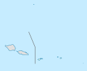
Dystrykt Manuʻa
| dystrykt | |
(c) Marshman, CC-BY-SA-3.0 | |
| Państwo | |
|---|---|
| Terytorium nieinkorporowane | |
| Powierzchnia | 58,6 km² |
| Populacja • liczba ludności |
|
| • gęstość | 23 os./km² |
| Szczegółowy podział administracyjny | |
| Liczba wsi | 8 |
| 14,20861°S 169,55278°W/-14,208611 -169,552778 | |
Dystrykt Manuʻa – jednostka administracyjna Samoa Amerykańskiego.
Dystrykt Manuʻa składa się z wysp: Taʻū, Ofu oraz Olosega. Na jego terenie znajduje się 8 wiosek:
- Faleasao
- Leusoaliʻi
- Luma
- Maia
- Ofu
- Olosega
- Sili
- Siʻufaga
Media użyte na tej stronie
The flag of Navassa Island is simply the United States flag. It does not have a "local" flag or "unofficial" flag; it is an uninhabited island. The version with a profile view was based on Flags of the World and as a fictional design has no status warranting a place on any Wiki. It was made up by a random person with no connection to the island, it has never flown on the island, and it has never received any sort of recognition or validation by any authority. The person quoted on that page has no authority to bestow a flag, "unofficial" or otherwise, on the island.
(c) Marshman, CC-BY-SA-3.0
Ofu, Manu‘a Islands, American Samoa; viewed from the village of Sili on Olosega
Autor: NordNordWest, Licencja: CC BY-SA 3.0
Location map of American Samoa


