Dystrykt Shangla
| Dystrykt | |
 | |
| Państwo | |
|---|---|
| Prowincja | Chajber Pasztunchwa |
| Siedziba | Shangla |
| Powierzchnia | 1586 km² |
| Populacja (1998) • liczba ludności | 434 563 |
| • gęstość | 274 os./km² |
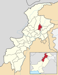
Położenie na mapie | |
Dystrykt Shangla – dystrykt w północnym Pakistanie w prowincji Chajber Pasztunchwa. W 1998 roku liczył 434 563 mieszkańców (z czego 51,48% stanowili mężczyźni) i obejmował 53 382 gospodarstw domowych[1]. Siedzibą administracyjną dystryktu jest Shangla.
Przypisy
- ↑ Shangla District at a glance (ang.). [dostęp 2011-05-23].
Media użyte na tej stronie
Autor: CerelacKhan, Licencja: CC BY-SA 3.0
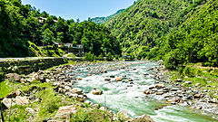
Shangla District (Urdu: ضلع شانگه) is located in the Khyber Pakhtunkhwa province of Pakistan. The district headquarters are located at Alpuri.[1] It was previously a subdivision of Swat District, but was upgraded to the status of a district on July 10, 1995[2] by the then Chief Minister Aftab Khan Sherpao. The total area of the district is 1,586 square kilometres.[2] Shangla comprises two sub division, Alpuri and Puran Tehsil.[1] There are four (4) sub tehsils i.e. Besham, Chakesar, Martung and Makhuzai. Shangla has the lowest Human Development Index in the province and second lowest in the country
Autor: Milenioscuro, Licencja: CC BY-SA 4.0
Locator map of Shangla district in Khyber Pakhtunkhwa, Pakistan
(c) Pahari Sahib, CC-BY-SA-3.0
Flag of Khyber Pakhtunkhwa. Created using en:Inkscape.
Pahari Sahib 11:15, 11 May 2007 (UTC)


