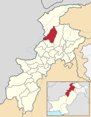
Dystrykt Upper Dir
| Dystrykt | |
 | |
| Państwo | |
|---|---|
| Prowincja | Chajber Pasztunchwa |
| Siedziba | Dir |
| Powierzchnia | 3699 km² |
| Populacja (1998) • liczba ludności | 575 852 |
| • gęstość | 155,7 os./km² |
Położenie na mapie | |
Dystrykt Upper Dir (paszto: دیر بالا) – dystrykt w północnym Pakistanie w prowincji Chajber Pasztunchwa. W 1998 roku liczył 575 852 mieszkańców (z czego 50,63% stanowili mężczyźni) i obejmował 71 705 gospodarstw domowych[1]. Siedzibą administracyjną dystryktu jest Dir.
Przypisy
- ↑ Upper Dir District at a glance (ang.). [dostęp 2011-05-23].
Media użyte na tej stronie
Autor: Milenioscuro, Licencja: CC BY-SA 4.0
Locator map of Upper Dir district in Khyber Pakhtunkhwa, Pakistan
Autor: Murtaza Mahmud, Licencja: CC BY-SA 4.0
Katoora Lake (also called Jaz Dand) is situated in the Lamoti Valley of Upper Dir, KPK at an altitude of 11,500 ft approximately. Most of the time, this lake is surrounded by high mountains covered with snow. The best season to visit it is August/September. However, June and July are also good months for a tour, if you are prepared for random monsoon showers. The level of difficulty for trekking in the area may be considered ‘moderate’ for regular trekkers/hikers.
(c) Pahari Sahib, CC-BY-SA-3.0
Flag of Khyber Pakhtunkhwa. Created using en:Inkscape.
Pahari Sahib 11:15, 11 May 2007 (UTC)


