Dystrykty Nepalu
Dystrykt Nepalu – jednostka podziału administracyjnego Nepalu. Jest ich 75 w 14 strefach. Dystrykty to administracyjnie najbardziej aktywne jednostki podziału kraju. Dystrykty dzielą się dalej na: village development committee (VDC; "komitet rozwoju wsi") dla obszarów wiejskich lub municipality dla obszarów miejskich. Ich liczba jest różna dla różnych dystryktów, np. Dystrykt Saptari ma 115 podjednostek, a Dystrykt Manang 15. Według podziału Nepalu według charakterystyki topograficznej, w górskim regionie kraju jest 16 dystryktów, we wzgórzystej 39, a na nizinach 20[1].
Lista dystryktów w poszczególnych strefach
W nawiasach stolice dystryktów
Bagmati
- Dystrykt Bhaktapur (Bhaktapur)
- Dystrykt Dhading (Dhading Besi)
- Dystrykt Katmandu (Katmandu)
- Dystrykt Kavrepalanchok (Dhulikhel)
- Dystrykt Lalitpur (Patan)
- Dystrykt Nuwakot (Bidur)
- Dystrykt Rasuwa (Dhunche)
- Dystrykt Sindhupalchowk (Chautara)
Bheri
- Dystrykt Banke (Nepalgańdźj)
- Dystrykt Bardiya (Gularia)
- Dystrykt Dailekh (Dullu)
- Dystrykt Jajarkot (Khalanga)
- Dystrykt Surkhet (Surkhet)
Dhawalagiri
Gandaki
- Dystrykt Gorkha (Gorkha)
- Dystrykt Kaski (Pokhara)
- Dystrykt Lamjung (Bensi Sahar)
- Dystrykt Manang (Chame)
- Dystrykt Syangja (Syangja)
- Dystrykt Tanahu (Damauli)
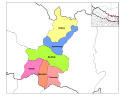
Dźanakpur
- Dystrykt Dhanusa (Janakpur)
- Dystrykt Dholkha (Charikot)
- Dystrykt Mahottari (Jaleswor)
- Dystrykt Ramechhap (Manthali)
- Dystrykt Sarlahi (Malangwa)
- Dystrykt Sindhuli (Sindhuli Madhi)
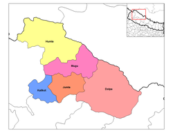
Karnali
- Dystrykt Dolpa (Dolpa)
- Dystrykt Humla (Simikot)
- Dystrykt Jumla (Jumla Khalanga)
- Dystrykt Kalikot (Kalikot)
- Dystrykt Mugu (Gamgadhi)
Kośi
- Dystrykt Bhojpur (Bhojpur)
- Dystrykt Dhankuta (Dhankuta)
- Dystrykt Morang (Biratnagar)
- Dystrykt Sankhuwasabha (Khandbari)
- Dystrykt Sunsari (Inaruwa)
- Dystrykt Terhathum (Manglung)
Lumbini
- Dystrykt Arghakhanchi (Sandhikharka)
- Dystrykt Gulmi (Tamghas)
- Dystrykt Kapilvastu (Taulihawa)
- Dystrykt Nawalparasi (Parasi)
- Dystrykt Palpa (Tansen)
- Dystrykt Rupandehi (Bhairahawa)
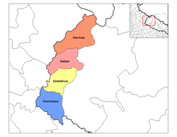
Mahakali
- Dystrykt Baitadi (Baitadi)
- Dystrykt Dadeldhura (Dadeldhura)
- Dystrykt Darchula (Darchula)
- Dystrykt Kanchanpur (Mahendara Nagar)
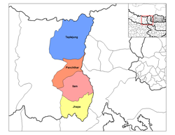
Meći
- Dystrykt Ilam (Ilam)
- Dystrykt Jhapa (Chandragadhi)
- Dystrykt Panchthar (Phidim)
- Dystrykt Taplejung (Taplejung)
Narajani
- Dystrykt Bara (Kalaiya)
- Dystrykt Chitwan (Bharatpur)
- Dystrykt Makwanpur (Hetauda)
- Dystrykt Parsa (Birgańdź)
- Dystrykt Rautahat (Gaur)
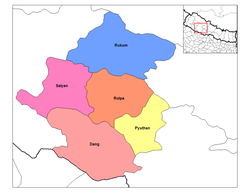
Rapti
- Dystrykt Dang Deokhuri (Ghorahi)
- Dystrykt Pyuthan (Pyuthan)
- Dystrykt Rolpa (Liwang)
- Dystrykt Rukum (Musikot)
- Dystrykt Salyan (Salyan Khalanga)
Sagarmatha
- Dystrykt Khotang (Diktel)
- Dystrykt Okhaldhunga (Okhaldhunga)
- Dystrykt Saptari (Rajbiraj)
- Dystrykt Siraha (Siraha)
- Dystrykt Solukhumbu (Salleri)
- Dystrykt Udayapur (Gaighat)
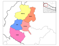
Seti
- Dystrykt Achham (Mangalsen)
- Dystrykt Bajhang (Chainpur)
- Dystrykt Bajura (Martadi)
- Dystrykt Doti (Dipayal)
- Dystrykt Kailali (Dhangadhi)
Przypisy
- ↑ 2. General Features of Nepalese Economy. W: Manoj Kumar Agarwal, Rudra Prasad Upadhyay: Tourism and economic development in Nepal. New Delhi: Northern Book Centre, 2006, s. 49. ISBN 81-7211-173-8.
Media użyte na tej stronie
Map of the districts of Koshi Zone (wp-EN) in Nepal. Created by Rarelibra 19:00, 18 September 2006 (UTC) for public domain use, using MapInfo Professional v8.5 and various mapping resources.
Map of the districts of Mechi Zone (wp-EN) in Nepal. Created by Rarelibra 19:32, 18 September 2006 (UTC) for public domain use, using MapInfo Professional v8.5 and various mapping resources.
Map of the districts of Bagmati Zone (wp-EN) in en:Nepal. Created by Rarelibra 18:07, 18 September 2006 (UTC) for public domain use, using MapInfo Professional v8.5 and various mapping resources.
Map of the districts of Mahakali Zone (wp-EN) in Nepal. Created by Rarelibra 19:32, 18 September 2006 (UTC) for public domain use, using MapInfo Professional v8.5 and various mapping resources.
Blank map of the districts of Nepal (2006 status, outdated).
Map of the districts of Lumbini Zone (wp-EN) in Nepal. Created by Rarelibra 19:31, 18 September 2006 (UTC) for public domain use, using MapInfo Professional v8.5 and various mapping resources.
Map of the districts of Dhawalagiri Zone (wp-EN) in Nepal. Created by Rarelibra 18:15, 18 September 2006 (UTC) for public domain use, using MapInfo Professional v8.5 and various mapping resources.
Map of the districts of Sagarmatha Zone (wp-EN) in Nepal. Created by Rarelibra 19:35, 18 September 2006 (UTC) for public domain use, using MapInfo Professional v8.5 and various mapping resources.
Map of the districts of Rapti Zone (wp-EN) in Nepal. Created by Rarelibra 19:33, 18 September 2006 (UTC) for public domain use, using MapInfo Professional v8.5 and various mapping resources.
Map of the districts of Karnali Zone in Nepal. Created by Rarelibra 18:59, 18 September 2006 (UTC) for public domain use, using MapInfo Professional v8.5 and various mapping resources.
Map of the districts of Seti Zone (wp-EN) in Nepal. Created by Rarelibra 19:59, 18 September 2006 (UTC) for public domain use, using MapInfo Professional v8.5 and various mapping resources.
Map of the districts of Janakpur Zone (wp-EN) in Nepal. Created by Rarelibra 18:58, 18 September 2006 (UTC) for public domain use, using MapInfo Professional v8.5 and various mapping resources.
Map of the districts of Gandaki Zone (wp-EN) in Nepal. Created by Rarelibra 18:57, 18 September 2006 (UTC) for public domain use, using MapInfo Professional v8.5 and various mapping resources.
Map of the districts of Bheri Zone (wp-EN) in Nepal. Created by Rarelibra 18:12, 18 September 2006 (UTC) for public domain use, using MapInfo Professional v8.5 and various mapping resources.
Map of the districts of Narayani Zone (wp-EN) in Nepal. Created by Rarelibra 19:33, 18 September 2006 (UTC) for public domain use, using MapInfo Professional v8.5 and various mapping resources.


