Ełektrozawodśka (stacja szybkiego tramwaju)
| ||
 | ||
| Państwo | ||
| Obwód | ||
| Miejscowość | Krzywy Róg | |
| Dzielnica | Mikrorejon Zaricznyj | |
| Data otwarcia | 27 maja 2000 | |
| Liczba peronów | 2 | |
| Liczba krawędzi peronowych | 2 | |
| Długość peronu | 102 m | |
| 2M Zariczna – Kilcewa | ||
| Poprzednia stacja | Zariczna | |
| Następna stacja | Industrialna | |
| 3M Zariczna – Nowokryworiźkyj HZK | ||
| Poprzednia stacja | Zariczna | |
| Następna stacja | Industrialna | |
| 4M Zariczna – Piwdennyj HZK | ||
| Poprzednia stacja | Zariczna | |
| Następna stacja | Industrialna | |
Położenie na mapie Krzywego Rogu  | ||
Położenie na mapie Ukrainy  (c) Karte: NordNordWest, Lizenz: Creative Commons by-sa-3.0 de | ||
Położenie na mapie obwodu dniepropetrowskiego  | ||
| Portal | ||
| ||||||||||||||||||||||||||||||||||||||||||||||||||||||||||||||||||||||||||||||||||||||||||||||||||||||||||||||||||||||||||||||||||||||||||||||||||||||||||||||||||||||||||||||||||||||||||||||||||||||||||||||||||||||||||||||||||||||||||||||||||||||||||||||||||||||||||||||||||||||||||||||||||||||||||||||||||||||||||||||||||||||||||||||||||||||||||||||||||||||||||||||||||||||||||||||||||||||||||
Ełektrozawodśka (ukr. Електрозаводська) – podziemna stacja szybkiego tramwaju w Krzywym Rogu na Ukrainie. Została otwarta 27 maja 2000 r. w 200. rocznicę nadania Krzywemu Rogowi praw miejskich[1].
Konstrukcja
Ełektrozawodśka jest płytką stacją kolumnową. Stacja zbudowana jest z dwóch poziomów. Część naziemna składa się z holu, natomiast w części podziemnej położone są perony. Tory tramwajowe rozgraniczono ścianą z łukowatymi otworami. Ściany stacji wykończono niewielkimi kaflami ceramicznymi, natomiast podłogi wyłożono kamiennymi płytkami o nieregularnych kształtach. Oświetlenie peronów stanowią lampy fluorescencyjne[1].
Galeria

Fragment ściany dzielącej stację
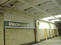
Tablica z nazwą stacji
Zobacz też
Przypisy
- ↑ a b Stancyja «Ełektrozawodśka» – «Эłektrozawodskaja» (ros.). metroworld.ruz.net. [dostęp 2020-01-24].
Transport zbiorowy w Krzywym Rogu
| Środki transportu |
| ||
|---|---|---|---|
| Infrastruktura |
|
![]()
Media użyte na tej stronie
Ukraine adm location map.svg
(c) Karte: NordNordWest, Lizenz: Creative Commons by-sa-3.0 de
Location map of Ukraine
(c) Karte: NordNordWest, Lizenz: Creative Commons by-sa-3.0 de
Location map of Ukraine


BSicon ulBHF.svg
underground train station (legend icon)
underground train station (legend icon)

BSicon uexlBHF.svg
ex underground train station (legend icon)
ex underground train station (legend icon)


BSicon ulHST.svg
underground train stop (legend icon)
underground train stop (legend icon)

BSicon uexlHST.svg
ex underground train stop (legend icon)
ex underground train stop (legend icon)


BSicon ulDST.svg
underground service station (legend icon)
underground service station (legend icon)

BSicon uexlDST.svg
ex underground service station (legend icon)
ex underground service station (legend icon)

BSicon lBST.svg
non-passenger stop (legend icon)
non-passenger stop (legend icon)

BSicon exlBST.svg
ex non-passenger stop (legend icon)
ex non-passenger stop (legend icon)

BSicon ulBST.svg
underground service stop (legend icon)
underground service stop (legend icon)

BSicon uexlBST.svg
ex underground service stop (legend icon)
ex underground service stop (legend icon)


BSicon expHST.svg
local-only minor station
local-only minor station

BSicon upHST.svg
Icons for railway description
Icons for railway description

BSicon uexpHST.svg
out-of-use local-only minor metro station
out-of-use local-only minor metro station


BSicon uexENDEe.svg
Railroad BSicon
Railroad BSicon


BSicon uSTR.svg
Underground straight track
Underground straight track

BSicon uexSTR.svg
ex underground straight track
ex underground straight track


BSicon extSTR.svg
straight line, modified version (+ex, +t, +ext)
straight line, modified version (+ex, +t, +ext)

BSicon utSTR.svg
underground tunnel straight track
underground tunnel straight track

BSicon uextSTR.svg
ex underground tunnel straight track
ex underground tunnel straight track

BSicon hSTR.svg
high level track
high level track

BSicon exhSTR.svg
ex high level track
ex high level track

BSicon uhSTR.svg
underground high level track
underground high level track

BSicon uexhSTR.svg
ex underground high level track
ex underground high level track

BSicon hSTRae.svg
Bridge (big)
Bridge (big)

BSicon exhSTRae.svg
Bridge (big)
Bridge (big)


BSicon uexhSTRae.svg
BS template transport icon
BS template transport icon

BSicon hKRZWae.svg
bridge over water straight (big)
bridge over water straight (big)

BSicon exhKRZWae.svg
bridge over water straight (big)
bridge over water straight (big)


BSicon uexKRZWu.svg
for BS models. water tunnel, urban(blue), not in use.
for BS models. water tunnel, urban(blue), not in use.

BSicon KMW.svg
mileage change
mileage change

BSicon exKMW.svg
ex mileage change
ex mileage change

BSicon uKMW.svg
A mile-marker for metros/canals
A mile-marker for metros/canals

BSicon uexKMW.svg
mileage change
mileage change


BSicon exSTR+GRZq.svg
Border icon
Border icon

BSicon ÜST.svg
Track change (new design)
Track change (new design)

BSicon exÜST.svg
track change (new design)
track change (new design)

BSicon uÜST.svg
Track switch, metro/light rail
Track switch, metro/light rail

BSicon uexÜST.svg
track change, metro/light rail (new design)
track change, metro/light rail (new design)

BSicon BUE.svg
level crossing straight
level crossing straight

BSicon exSKRZ-YBUE.svg
Disused railway line level crossing on minor road.
Disused railway line level crossing on minor road.

BSicon uBUE.svg
underground level crossing straight
underground level crossing straight

BSicon uexBUE.svg
Ex underground level crossing straight
Ex underground level crossing straight


BSicon ELCa.svg
Autor: Lekko gazowany, Licencja: CC BY-SA 3.0
electrified line start sign for railways
Autor: Lekko gazowany, Licencja: CC BY-SA 3.0
electrified line start sign for railways

BSicon ELCe.svg
Autor: Lekko gazowany, Licencja: CC BY-SA 3.0
electrified line end sign for railways
Autor: Lekko gazowany, Licencja: CC BY-SA 3.0
electrified line end sign for railways


Flag of Dnipropetrovsk Oblast.svg
Flag of Dnipropetrovsk Oblast, Ukraine
Flag of Dnipropetrovsk Oblast, Ukraine

BSicon uDST.svg
underground non-passenger station
underground non-passenger station

BSicon uABZq+l.svg
BS template transport icon
BS template transport icon

BSicon uKBHFa.svg
Underground terminal station
Underground terminal station


BSicon ueBHF.svg
ex underground station
ex underground station

BSicon uHST.svg
underground stop
underground stop


Dnipropetrovsk oblast location map.svg
Autor: RosssW, Licencja: CC BY-SA 4.0
Districts of the Dnipropetrovsk region, from July 17, 2020
Autor: RosssW, Licencja: CC BY-SA 4.0
Districts of the Dnipropetrovsk region, from July 17, 2020

Kryvyi Rih Elektrozavodska2.jpg
Autor: Serguei Bolachenko, Licencja: CC BY-SA 3.0
Northbound platform of Elektrozavodska metro station, Kryvyi Rih Metrotram
Autor: Serguei Bolachenko, Licencja: CC BY-SA 3.0
Northbound platform of Elektrozavodska metro station, Kryvyi Rih Metrotram
Kryvyi Rih Elektrozavodska1.jpg
Autor: Serguei Bolachenko, Licencja: CC BY-SA 3.0
Platforms of Elektrozavodska metro station, Kryvyi Rih Metrotram, view towards Zarichna
Autor: Serguei Bolachenko, Licencja: CC BY-SA 3.0
Platforms of Elektrozavodska metro station, Kryvyi Rih Metrotram, view towards Zarichna

Kryvyi Rih Elektrozavodska3.jpg
Autor: Serguei Bolachenko, Licencja: CC BY-SA 3.0
Route map at Elektrozavodska metro station, Kryvyi Rih Metrotram
Autor: Serguei Bolachenko, Licencja: CC BY-SA 3.0
Route map at Elektrozavodska metro station, Kryvyi Rih Metrotram

BSicon uKBHFeq.svg
underground terminal station
underground terminal station

Coat of Arms of Kryvyi Rih.svg
Coat of Arms Kryvy Rih Ukraine
Coat of Arms Kryvy Rih Ukraine

Kryvyi Rih Metrotram location map.svg
Autor: Szczecinolog, Licencja: CC BY-SA 4.0
Mapa lokalizacyjna linii Krzyworoskiego szybkiego tramwaju
Autor: Szczecinolog, Licencja: CC BY-SA 4.0
Mapa lokalizacyjna linii Krzyworoskiego szybkiego tramwaju

BSicon uKBHFe.svg
Underground terminal station
Underground terminal station


BSicon utBHF.svg
underground tunnel station
underground tunnel station

BSicon uBHF.svg
Underground station
Underground station


BSicon uSTRq.svg
underground straight line aqross (according to naming convention, name + modifier)
underground straight line aqross (according to naming convention, name + modifier)