E35 (trasa europejska)
| Długość | 1817 km | ||||||||||||||||||||||||||||||||||||||||||||||||||||||||||||||||||||||||||||||||||||||||||||||||||||||||||||||||||||||||||||||||||||||||||||||||||||||||||||||||||||||||
| Państwa | Holandia, Niemcy, Szwajcaria, Włochy | ||||||||||||||||||||||||||||||||||||||||||||||||||||||||||||||||||||||||||||||||||||||||||||||||||||||||||||||||||||||||||||||||||||||||||||||||||||||||||||||||||||||||
| Mapa | |||||||||||||||||||||||||||||||||||||||||||||||||||||||||||||||||||||||||||||||||||||||||||||||||||||||||||||||||||||||||||||||||||||||||||||||||||||||||||||||||||||||||
 | |||||||||||||||||||||||||||||||||||||||||||||||||||||||||||||||||||||||||||||||||||||||||||||||||||||||||||||||||||||||||||||||||||||||||||||||||||||||||||||||||||||||||
E35 – trasa europejska bezpośrednia północ-południe.
E35 zaczyna się w Amsterdamie w Holandii, kończy się w Rzymie we Włoszech. Długość trasy wynosi 1817 km.
Przebieg trasy
- autostrada A2 - Amsterdam - E19 - E22 - E231 - Utrecht - E30
- autostrada A12 - Arnhem
- autostrada A3 - E34 - Duisburg - E37 - Kolonia - E40 - E44 - Limburg an der Lahn
- autostrada A67 - E42 - Frankfurt n. Menem
- autostrada A5 - E451 - Darmstadt - Heidelberg - E50 - Karlsruhe - E52 - Offenburg - Fryburg Bryzgowijski - E54
- autostrada A2 - E25 - E60 - Bazylea
- autostrada A1
- autostrada A2 - Lucerna - E41 - E43 - Lugano
- autostrada A9
- autostrada A8 - E62 - Lainate
- autostrada A50 - Mediolan - E64
- autostrada A1 - E70 - E31 - Parma - E45 - Modena - Bolonia - Prato - E76 - Florencja - E78 - Arezzo - E45 - Rzym
Stary system numeracji
Do 1983 roku[a] obowiązywał poprzedni system numeracji, według którego oznaczenie E35 dotyczyło trasy: Amsterdam — Amersfoort — Zwolle — Groningen — Winschoten — Oldenburg — Brema — Hamburg. Arteria E35 była wtedy zaliczana do kategorii „B”, w której znajdowały się trasy europejskie będące odgałęzieniami oraz łącznikami[2].
Drogi w ciągu dawnej E35
Lista dróg opracowana na podstawie materiału źródłowego[3][4]
| |
|
Galeria

A3 w Niemczech w okolicach Kolonii
 © Raimond Spekking / CC BY-SA 4.0 (via Wikimedia Commons)
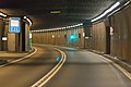
Tunel Świętego Gotarda w Szwajcarii.
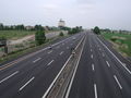
A1 we Włoszech koło Modeny
Uwagi
Przypisy
- ↑ Organizacja Narodów Zjednoczonych: European Agreement on main international traffic arteries (AGR) (with annexes and list of roads). Concluded at Geneva on 15 November 1975 / Accord européen sur les grandes routes de trafic international (AGR) [avec annexes et listes de routes. Concluà Genève le 15 novembre 1975] (ang.). treaties.un.org. [dostęp 2018-06-23].
- ↑ Organizacja Narodów Zjednoczonych: Declaration on the construction of main international traffic arteries signed at Geneva on 16 September 1950 / Declaration sur la construction de grandes routes de trafic international signee a Geneve le 16 septembre 1950 (fr. • ang.). treaties.un.org, 1951. [dostęp 2017-12-01].
- ↑ Hegi Gyula, Domokos György: EUROPE L'EUROPE EUROPA ЕВРОПА Road atlas Atlas Routier Autoatlas АТЛАС автомобильных дорог. Budapeszt: Cartographia Budapest, 1981. ISBN 963-350-412-0.
- ↑ Patrick Scholl: Autobahnen und Bundesstraßen 1985 (niem.). autobahnatlas-online.de. [dostęp 2018-10-06].

Media użyte na tej stronie

Bundesautobahn 3 number.svg
German Autobahn number signet.
German Autobahn number signet.


BAB-Grenze-dark.svg
Sign no. 392 - Customs, darker version
Sign no. 392 - Customs, darker version

AS-prom rzeka-icon.svg
prom rzeka-icon.
prom rzeka-icon.

AB-Tunnel.svg
(Motorway) tunnel Icon. Drawing similar to Swiss road signs.
(Motorway) tunnel Icon. Drawing similar to Swiss road signs.


AB-Tank.svg
Gas station symbol
Gas station symbol


20 airtransportation inv.svg
AIGA Air Transportation sign (inverted)
AIGA Air Transportation sign (inverted)


Gotthard-Strassentunnel Nord-Süd-8915.jpg
© Raimond Spekking / CC BY-SA 4.0 (via Wikimedia Commons)
Gotthard-Strassentunnel in einer Nord-Süd-Befahrung
Foto: Im Tunnel ein Hinweisschild auf die Radiofrequenzen des Tunnelradios
© Raimond Spekking / CC BY-SA 4.0 (via Wikimedia Commons)
Gotthard-Strassentunnel in einer Nord-Süd-Befahrung
Foto: Im Tunnel ein Hinweisschild auf die Radiofrequenzen des Tunnelradios

Autostrada A50 Italia.svg
Icon of autostrada A50 "Tangenziale Ovest di Milano", Italy.
Icon of autostrada A50 "Tangenziale Ovest di Milano", Italy.

Autostrada A9 Italia.svg
Icon of autostrada A9 "Autostrada dei laghi", Italy.
Icon of autostrada A9 "Autostrada dei laghi", Italy.


Autostrada A1dir Italia.svg
Icon of autostrada A1/diramazione, Italy.
Icon of autostrada A1/diramazione, Italy.

BAB3 Koelner Ring.jpg
Bundesautobahn 3 and 4 in Cologne with eight-lane section of Cologne Beltway
Bundesautobahn 3 and 4 in Cologne with eight-lane section of Cologne Beltway


Autostrada A1 Italia.svg
Icon of autostrada A1 "Autostrada del Sole", Italy.
Icon of autostrada A1 "Autostrada del Sole", Italy.


A2Swiss.svg
sxildo de svisa auxtovojo
sxildo de svisa auxtovojo

Autostrada A8 Italia.svg
Icon of autostrada A8 "Autostrada dei laghi", Italy.
Icon of autostrada A8 "Autostrada dei laghi", Italy.