Ealing Common
 Budynek stacji przy Uxbridge Road | |
| Państwo | |
|---|---|
| Kraj | |
| Miejscowość | |
| Dzielnica | Ealing |
| Data otwarcia | 1879 |
| Poprzednie nazwy | Ealing Common and West Acton |
| Liczba peronów | 2 |
| Liczba krawędzi peronowych | 2 |
| District Line (Nitka Ealing) | |
| Poprzednia stacja | |
| Następna stacja | |
| Piccadilly line (Nitka Uxbridge) | |
| Poprzednia stacja | |
| Następna stacja | North Ealing |
Położenie na mapie gminy Ealing  Contains Ordnance Survey data © Crown copyright and database right, CC BY-SA 3.0 | |
Położenie na mapie Wielkiej Brytanii  (c) Karte: NordNordWest, Lizenz: Creative Commons by-sa-3.0 de | |
Położenie na mapie Anglii  | |
Położenie na mapie Wielkiego Londynu  Contains Ordnance Survey data © Crown copyright and database right, CC BY-SA 3.0 | |
| Portal | |
Ealing Common – stacja w Londynie, w dzielnicy Ealing obsługująca pociągi metra linii Piccadilly oraz District[1]. Znajduje się w trzeciej strefie biletowej[2]. Sąsiednie stacje linii Piccadilly to Acton Town oraz North Ealing, natomiast dla District line to Acton Town i Ealing Broadway.
Stacja posiada 2 perony obsługujące obie linie. Została otwarta 1 lipca 1879 przez Metropolitan District Railway (obecnie District line) na nitce z Turnham Green do Ealing Broadway. Stacja zanim otrzymała obecną nazwę, nazywała się Ealing Common and West Acton[3].
Galeria

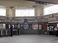
Wnętrze (wrzesień 2006)

Odjazd pociągu Piccadilly line

Przypisy
- ↑ Schemat sieci metra w Londynie. tfl.gov.uk. [zarchiwizowane z tego adresu (2008-06-26)]. [dostęp 2010-12-01]
- ↑ Lista stacji i stref biletowych metra londyńskiego. tfl.gov.uk. [zarchiwizowane z tego adresu (2008-06-26)]. [dostęp 2010-12-01]
- ↑ Rose Douglas,The London Underground, A Diagrammatic History, 1999 Douglas Rose/Capital Transport, isbn=1-85414-219-4
| Linia główna |
|
|---|---|
| Odgałęzienie Wimbledon |
|
| Odgałęzienie Edgware Road | |
| Odgałęzienie Kensington (Olympia) | |
| Odgałęzienie Richmond/Ealing |
|
| Nitka Richmond |
|
| Nitka Ealing |
![]()
| Linia główna |
|
|---|---|
| Odgałęzienie Uxbridge |
|
| Odgałęzienie Heathrow |
|
![]()
Media użyte na tej stronie
(c) Karte: NordNordWest, Lizenz: Creative Commons by-sa-3.0 de
Location map of the United Kingdom
Contains Ordnance Survey data © Crown copyright and database right, CC BY-SA 3.0
Map of Greater London, UK with the following information shown:
- Administrative borders
- Coastline, lakes and rivers
- Roads and railways
- Urban areas
The data includes both primary routes and railway lines.
Equirectangular map projection on WGS 84 datum, with N/S stretched 160%
Geographic limits:
- West: 0.57W
- East: 0.37E
- North: 51.72N
- South: 51.25N

Blue Shield - the Distinctive emblem for the Protection of Cultural Property. The distinctive emblem is a protective symbol used during armed conflicts. Its use is restricted under international law.


Flag of England. Saint George's cross (a red cross on a white background), used as the Flag of England, the Italian city of Genoa and various other places.
Autor: Sunil060902, Licencja: CC BY-SA 3.0
Ealing Common tube station


Ealing Common underground station platforms, southbound en:Piccadilly Line train departs (September 2006)

Autor: Sunil060902, Licencja: CC BY-SA 3.0
Ealing Common tube station platform roundel

Ealing Common underground station interior (September 2006)
Contains Ordnance Survey data © Crown copyright and database right, CC BY-SA 3.0
Blank map of the London Borough of Ealing, showing electoral wards used from 2002 to 2022.
Equirectangular map projection on WGS 84 datum, with N/S stretched 160%
Geographic limits:
- West: 0.425W
- East: 0.24W
- North: 51.565N
- South: 51.485N

Autor: Sunil060902, Licencja: CC BY-SA 3.0
Ealing Common tube station looking north ("westbound")