East Acton (stacja metra)
 | |
| Państwo | |
|---|---|
| Miejscowość | Londyn |
| Dzielnica | East Acton |
| Data otwarcia | 1920 |
| Liczba peronów | 2 |
| Central Line | |
| Poprzednia stacja | North Acton |
| Następna stacja | White City |
Położenie na mapie gminy Hammersmith and Fulham  Contains Ordnance Survey data © Crown copyright and database right, CC BY-SA 3.0 | |
Położenie na mapie Wielkiej Brytanii  (c) Karte: NordNordWest, Lizenz: Creative Commons by-sa-3.0 de | |
Położenie na mapie Anglii  | |
Położenie na mapie Wielkiego Londynu  Contains Ordnance Survey data © Crown copyright and database right, CC BY-SA 3.0 | |
| Portal | |
East Acton – stacja londyńskiego metra położona na trasie Central Line pomiędzy stacjami White City a North Acton. Znajduje się we wschodniej części dzielnicy Acton w gminie London Borough of Hammersmith and Fulham, w drugiej strefie biletowej.
Stacja została otwarta w 1920 roku w wyniku rozbudowy Central London Railway (przemianowanej w 1937 roku na Central Line) w rejonie Ealing Broadway[1]. Powstała celem połączenia West London Line w pobliżu Shepherd’s Bush, Great Western Railway do Birmingham i głównej linii do Bristolu z Ealing Broadway. Central London Railway było wyłącznie linią pasażerską, jednak w 1938 roku otwarto dodatkowo dwa tory towarowe dla Great Western Railway, które zostały zamknięte w 1964 roku[2]. Ich pozostałości widoczne są do dziś na północ od stacji East Acton.
Galeria

widok na wschód
widok na wschód

widok na zachód

symbol stacji
Przypisy
| Linia główna | |
|---|---|
| Odgałęzienie West Ruislip | |
| Odgałęzienie Ealing Broadway | |
| Odgałęzienie Woodford | |
| Odgałęzienie Epping |
![]()
Media użyte na tej stronie
(c) Karte: NordNordWest, Lizenz: Creative Commons by-sa-3.0 de
Location map of the United Kingdom
Contains Ordnance Survey data © Crown copyright and database right, CC BY-SA 3.0
Map of Greater London, UK with the following information shown:
- Administrative borders
- Coastline, lakes and rivers
- Roads and railways
- Urban areas
The data includes both primary routes and railway lines.
Equirectangular map projection on WGS 84 datum, with N/S stretched 160%
Geographic limits:
- West: 0.57W
- East: 0.37E
- North: 51.72N
- South: 51.25N


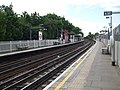
East Acton Underground Station, London

Autor: Martin Belam aka currybet, Licencja: CC BY-SA 2.0
East Acton station

Autor: Sunil060902, Licencja: CC BY-SA 3.0
Roundel on East Acton tube station westbound platform

Autor: Sunil060902, Licencja: CC BY-SA 3.0
East Acton tube station looking west. The former GWR tracks (immediately to the north of the Central line) were lifted many years ago and vegetation has taken over
Contains Ordnance Survey data © Crown copyright and database right, CC BY-SA 3.0
Blank map of the London Borough of Hammersmith and Fulham, showing electoral wards.
Equirectangular map projection on WGS 84 datum, with N/S stretched 160%
Geographic limits:
- West: 0.26W
- East: 0.17W
- North: 51.54N
- South: 51.46N

Autor: Sunil060902, Licencja: CC BY-SA 3.0
East Acton tube station looking east