East Hampshire
| ||
| dystrykt niemetropolitalny | ||
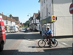
(c) Basher Eyre, CC BY-SA 2.0 Petersfield | ||
| Państwo | ||
|---|---|---|
| Kraj | ||
| Region | South East England | |
| Hrabstwo | Hampshire | |
| Siedziba | Petersfield | |
| Powierzchnia | 514,4 km² | |
| Populacja (2011) • liczba ludności | 115 608 | |
| • gęstość | 230 os./km² | |
| Położenie na mapie Hampshire Contains Ordnance Survey data © Crown copyright and database right, CC BY-SA 3.0 | ||
| Strona internetowa | ||
| Portal | ||
East Hampshire – dystrykt w hrabstwie Hampshire w Anglii. W 2011 roku dystrykt liczył 115 608 mieszkańców[1].
Miasta
- Alton
- Bordon
- Petersfield
Inne miejscowości
Adhurst St Mary, Arford, Beech, Bentley, Bentworth, Binsted, Blackmoor, Blacknest, Blendworth, Bordean, Bramshott, Bucks Horn Oak, Buriton, Burkham, Catherington, Chalton, Chawton, Chidden, Clanfield, Cold Ash Hill, Colemore, Ditcham, Durford Wood, East Meon, East Tisted, East Worldham, Empshott, Farringdon, Finchdean, Flexcombe, Four Marks, Froxfield Green, Froyle, Golden Pot, Grayshott, Greatham, Griggs Green, Hartley Mauditt, Hawkley, Headley Down, Headley, High Cross, Hollywater, Holybourne, Horndean, Idsworth, Isington, Kingsley, Kitwood, Langrish, Lasham, Lindford, Liphook, Liss, Liss Forest, Longmoor, Lovedean, Lower Wield, Medstead, Monkwood, Neatham, Newton Valence, North Street, Nursted, Oakhanger, Oakshott, Priors Dean, Privett, Ramsdean, Ropley, Ropley Dean, Rowlands Castle, Selborne, Shalden, Sheet, Sleaford, Soldridge, Southrope, Standford, Steep, Stroud, Thedden, Upper Wield, West Liss, West Tisted, West Worldham, Weston, Wheatley, Whitehill, Woolmer, Worldham, Wyck.
Przypisy
- ↑ Area: East Hampshire (Local Authority) (ang.). Neighbourhood Statistics (ONS). [dostęp 2016-04-24]. [zarchiwizowane z tego adresu (2016-10-03)].
Media użyte na tej stronie
Flag of England. Saint George's cross (a red cross on a white background), used as the Flag of England, the Italian city of Genoa and various other places.
Contains Ordnance Survey data © Crown copyright and database right, CC BY-SA 3.0
Map of Hampshire, UK with East Hampshire highlighted.
Equirectangular map projection on WGS 84 datum, with N/S stretched 155%(c) Basher Eyre, CC BY-SA 2.0
Cyclist waits gap in Petersfield town centre He is coming out of Heath Road, wants to get across to the High Street by crossing the Dragon Street/College Street meeting point.


