East Staffordshire
| dystrykt niemetropolitalny | |
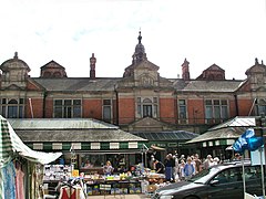
(c) Andy Potter, CC BY-SA 2.0 Burton upon Trent | |
| Państwo | |
|---|---|
| Kraj | |
| Region | West Midlands |
| Hrabstwo | Staffordshire |
| Siedziba | Burton upon Trent |
| Powierzchnia | 390 km² |
| Populacja (2011) • liczba ludności | 113 583 |
| • gęstość | 290 os./km² |
Położenie na mapie Staffordshire | |
| Strona internetowa | |
| Portal | |
East Staffordshire – dystrykt w hrabstwie Staffordshire w Anglii. W 2011 roku dystrykt liczył 113 583 mieszkańców[1].
Miasta
Inne miejscowości
Abbots Bromley, Anglesey, Anslow, Barton-under-Needwood, Blithfield, Bramshall, Branston, Brizlincote, Church Leigh, Croxden, Denstone, Draycott in the Clay, Dunstall, Ellastone, Hoar Cross, Marchington, Marchington Woodlands, Newborough, Ramshorn, Rangemore, Rocester, Rolleston on Dove, Spath, Stramshall, Stretton, Tatenhill, Tutbury, Winshill, Yoxall.
Przypisy
- ↑ Area: East Staffordshire (Local Authority) (ang.). Neighbourhood Statistics (ONS). [dostęp 2016-04-29]. [zarchiwizowane z tego adresu (2016-10-06)].
Media użyte na tej stronie
Flag of England. Saint George's cross (a red cross on a white background), used as the Flag of England, the Italian city of Genoa and various other places.
(c) Andy Potter, CC BY-SA 2.0
Burton Market The later of the two extant market buildings. This one has a beautifully galleried hall, its trussed roof supported by cast-iron pillars.
Autor:
- Staffordshire UK district map (blank).svg: Nilfanion, created using Ordnance Survey data
- derivative work: Renly (talk)
Map of Staffordshire, with East Staffordshire highlighted.


