Edgware Road (stacja metra na liniach Circle, District i H&M)
| ||
_building.JPG) Budynek stacji Edgware Road, 2009 | ||
| Państwo | ||
| Miejscowość | Londyn | |
| Dzielnica | Edgware Road | |
| Data otwarcia | 1863 | |
| Liczba peronów | 4 | |
| Circle Line (Linia główna) | ||
| Poprzednia stacja | Paddington | |
| Następna stacja | Baker Street | |
| Circle Line (Odgałęzienie Hammersmith) | ||
| Poprzednia stacja | Paddington | |
| District Line | ||
| Poprzednia stacja | Paddington | |
| Hammersmith & City Line | ||
| Poprzednia stacja | Paddington | |
| Następna stacja | Baker Street | |
Położenie na mapie City of Westminster  Contains Ordnance Survey data © Crown copyright and database right, CC BY-SA 3.0 | ||
Położenie na mapie Wielkiej Brytanii  (c) Karte: NordNordWest, Lizenz: Creative Commons by-sa-3.0 de | ||
Położenie na mapie Anglii  | ||
Położenie na mapie Wielkiego Londynu  Contains Ordnance Survey data © Crown copyright and database right, CC BY-SA 3.0 | ||
| Portal | ||
Edgware Road – stacja londyńskiego metra znajdująca się na skrzyżowaniu Chapel Street i Cabbell Street Road w City of Westminster. Zlokalizowana jest na trasach trzech linii metra: Circle Line, District Line i Hammersmith & City Line i bywa mylona ze stacją Edgware Road obsługującą Bakerloo Line, znajdującą się w odległości 150 metrów. W przeszłości podejmowano dyskusje na temat zmiany nazwy jednej ze stacji, ale żadne decyzje nie zostały podjęte[1].
Na stacji Edgware Road miała miejsce jedna z czterech eksplozji, jakie nastąpiły w czasie zamachów w Londynie 7 lipca 2005 roku. Mohammad Sidique Khan zdetonował bombę w pociągu linii Circle Line tuż po ruszeniu z czwartego peronu stacji, zabijając sześciu pasażerów oraz siebie[2].
Stację obsługują linie autobusowe: 18, 27, 205 i N18.
Galeria

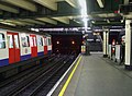
Platforma 1 stacji Edgware Road
Platforma 2 stacji Edgware Road

Rzeźba przed wejściem na stację
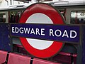
Symbol stacji
Przypisy
- ↑ Call to rename twin Tube stations (ang.). BBC News, 14.09.2007. [dostęp 2012-01-13].
- ↑ Suicide bombers' 'ordinary' lives (ang.). BBC News, 18.07.2005. [dostęp 2012-01-13].
| |||||||||||
| |||||||||||||||||||||
| ||||||
Media użyte na tej stronie
(c) Karte: NordNordWest, Lizenz: Creative Commons by-sa-3.0 de
Location map of the United Kingdom
Contains Ordnance Survey data © Crown copyright and database right, CC BY-SA 3.0
Map of Greater London, UK with the following information shown:
- Administrative borders
- Coastline, lakes and rivers
- Roads and railways
- Urban areas
The data includes both primary routes and railway lines.
Equirectangular map projection on WGS 84 datum, with N/S stretched 160%
Geographic limits:
- West: 0.57W
- East: 0.37E
- North: 51.72N
- South: 51.25N

Autor: Sunil060902, Licencja: CC BY-SA 3.0
Edgware Road station (Circle/District/Hammersmith & City lines). A short walk away from its namesake on the Bakerloo line


Autor: Rept0n1x, Licencja: CC BY-SA 3.0
The Window Cleaner sculpture, outside Edgware Road tube station, London.

_platform_1_look_west.JPG)
Autor: Sunil060902, Licencja: CC BY-SA 3.0
Edgware Road station (Circle/District/Hammersmith & City lines) platform 1 looking west. Usually used by through eastbound trains (except District, which terminate here).

_platform_2_look_west2.JPG)
Autor: Sunil060902, Licencja: CC BY-SA 3.0
Edgware Road tube station (Circle/District/Hammersmith & City lines) platform 2 looking west. Usually used by District line trains, which arrive from the west to terminate here, despite being laid out as a through platform.
Contains Ordnance Survey data © Crown copyright and database right, CC BY-SA 3.0
Blank map of the City of Westminster, showing electoral wards.
Equirectangular map projection on WGS 84 datum, with N/S stretched 160%
Geographic limits:
- West: 0.22W
- East: 0.1W
- North: 51.55N
- South: 51.48N
_stn_roundel.JPG)
Autor: Sunil060902, Licencja: CC BY-SA 3.0
Edgware Road tube station (Circle/District/Hammersmith & City lines) platforms roundel