Ehringshausen (Hesja)
| gmina | |||
 | |||
| |||
| Państwo | |||
|---|---|---|---|
| Kraj związkowy | |||
| Rejencja | Gießen | ||
| Powiat | Lahn-Dill | ||
| Powierzchnia | 45,43 km² | ||
| Wysokość | 186 m n.p.m. | ||
| Populacja (2015-12-31) • liczba ludności | 9265[1] | ||
| • gęstość | 203,65 os./km² | ||
| Numer kierunkowy | 06440, 06443, 06449 | ||
| Kod pocztowy | 35630 | ||
| Tablice rejestracyjne | LDK, DIL, WZ | ||
Adres urzędu: Rathausstraße 135630 Ehringshausen | |||
Położenie na mapie powiatu | |||
| 50°36′N 8°23′E/50,600000 8,383333 | |||
| Strona internetowa | |||
| Portal | |||
Ehringshausen – miejscowość i gmina w Niemczech, w kraju związkowym Hesja, w rejencji Gießen, w powiecie Lahn-Dill.
Współpraca
Miejscowości partnerskie[2]:
- Haverhill, Anglia
- Neustadt am Rennsteig, Turyngia
- Roquemaure, Francja
Przypisy
- ↑ Die Bevölkerung in Hessen am 31.12.2015 (niem.). statistik.hessen.de. [dostęp 2017-02-17].
- ↑ Współpraca
Media użyte na tej stronie
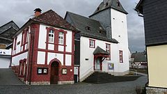
Backhaus und Kirche Niederlemp.jpg
Autor: Philipp Trümper, Licencja: CC BY 3.0
Backhaus (links) und Ev. Kirche (rechts) in der Obergasse, Ehringshausen-Niederlemp (Lahn-Dill-Kreis)
Autor: Philipp Trümper, Licencja: CC BY 3.0
Backhaus (links) und Ev. Kirche (rechts) in der Obergasse, Ehringshausen-Niederlemp (Lahn-Dill-Kreis)
Lahn-Dill-Kreis Ehringshaus.png
Autor: Andreas Trepte, Licencja: CC-BY-SA-3.0
The map shows a district in the area of Lahn-Dill-Kreis
Autor: Andreas Trepte, Licencja: CC-BY-SA-3.0
The map shows a district in the area of Lahn-Dill-Kreis


