Ellsworth (Kansas)
 | |
| Państwo | |
|---|---|
| Stan | |
| Hrabstwo | |
| Powierzchnia | 5,4 km² |
| Wysokość | 469 m n.p.m. |
| Populacja (2006) • liczba ludności • gęstość |
|
| Nr kierunkowy | 785 |
| Kod pocztowy | 67439 |
| Strona internetowa | |
| Portal | |
Ellsworth – miasto, siedziba hrabstwa Ellsworth w stanie Kansas, USA, położone nad rzeką Smoky Hill. W 2000 roku mieszkało tu 2965 osób.
Jest to siedziba więzienia stanowego dla Kansas (ang.: Kansas State Ellsworth Correctional Facility).
Historia
Miasto było głośnym centrum Dzikiego Zachodu, centrum spędu bydła i ośrodkiem hazardu i prostytucji, ponieważ przebiegała tędy nowo wybudowana kolej. Dziki Bill Hickok ubiegał się o stanowisko szeryfa Ellsworth w 1868, ale przegrał do byłego wojskowego E.W. Kingsbury. Kingsbury okazał się bardzo dobrym stróżem prawa i porządku, ale potrzebował w tym celu powołania miejscowej policji, jako że odpowiedzialny był za teren całego hrabstwa. Przemoc w Ellsworth była codziennością[1]. Szeryf Will Seamans został zastrzelony w ciągu pełnienia obowiązków 26 września 1869[2]. Później rewolwerowiec Wyatt Earp pełnił to stanowisko, ale nic historycznego tu nie zadziałał.
Przypisy
- ↑ Historia Ellsworth (ang.). [dostęp 2008-08-14].
- ↑ Officer Will Semans (ang.). [dostęp 2008-08-14]. [zarchiwizowane z tego adresu (2007-09-30)].
Bibliografia
- American Fact Finder (ang.). U.S. Census Burreau. [dostęp 2208=08-14]. [zarchiwizowane z tego adresu (2015-01-08)].zły zapis daty dostępu
Linki zewnętrzne
- Ellsworth City. skyways.lib.ks.us. [zarchiwizowane z tego adresu (2008-06-19)]. (ang.)
- Gazeta miejscowa: Ellsworth County Independent/Reporter (ang.)
Media użyte na tej stronie
Autor: Uwe Dedering, Licencja: CC BY-SA 3.0
Location map of the USA (without Hawaii and Alaska).
EquiDistantConicProjection:
Central parallel:
* N: 37.0° N
Central meridian:
* E: 96.0° W
Standard parallels:
* 1: 32.0° N
* 2: 42.0° N
Made with Natural Earth. Free vector and raster map data @ naturalearthdata.com.
Formulas for x and y:
x = 50.0 + 124.03149777329222 * ((1.9694462586094064-({{{2}}}* pi / 180))
      * sin(0.6010514667026994 * ({{{3}}} + 96) * pi / 180))
y = 50.0 + 1.6155950752393982 * 124.03149777329222 * 0.02613325650382181
      - 1.6155950752393982  * 124.03149777329222 *
     (1.3236744353715044  - (1.9694462586094064-({{{2}}}* pi / 180))
      * cos(0.6010514667026994 * ({{{3}}} + 96) * pi / 180))
The flag of Navassa Island is simply the United States flag. It does not have a "local" flag or "unofficial" flag; it is an uninhabited island. The version with a profile view was based on Flags of the World and as a fictional design has no status warranting a place on any Wiki. It was made up by a random person with no connection to the island, it has never flown on the island, and it has never received any sort of recognition or validation by any authority. The person quoted on that page has no authority to bestow a flag, "unofficial" or otherwise, on the island.
Autor: Doug Kerr, Licencja: CC BY-SA 2.0
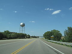
Ellsworth, Kansas water tower as seen from Kansas State Highway 156
Autor: Alexrk2, Licencja: CC BY 3.0
Ta mapa została stworzona za pomocą GeoTools.


