Eniwetok
| ||
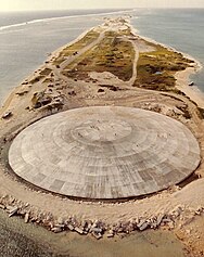
 Kopuła blisko Eniwetok, przykrywająca krater po amerykańskich testach broni nuklearnej | ||
| Państwo | ||
| Populacja (2006) • liczba ludności | 917 | |
Eniwetok – miasto na Wyspach Marshalla, na atolu Enewetak; 917 mieszkańców (2006).
Bibliografia
Media użyte na tej stronie
Oceania laea location map.svg
Autor: Uwe Dedering, Licencja: CC BY-SA 3.0
Location map of Oceania.
Autor: Uwe Dedering, Licencja: CC BY-SA 3.0
Location map of Oceania.
- Projection: Lambert azimuthal equal-area projection.
- Area of interest:
- N: 35.0° N
- S: -55.0° N
- W: 110.0° E
- E: 230.0° E (This is -130° E)
- Projection center:
- NS: -10.0° N
- WE: 170.0° E
- GMT projection: -JA170/-5/20c
- GMT region: -R79.58168799459713/-44.42200097096855/-120.83787447194456/33.90289238708686r
- GMT region for grdcut: -R80.0/-63.0/260.0/39.0r
- Made with Natural Earth. Free vector and raster map data @ naturalearthdata.com.
Runit Dome 001.jpg
Runit Dome (or Cactus Dome), Runit Island, Enewetak Atoll. Aerial view. In 1977-1980 the crater created by the Cactus shot of Operation Hardtack I was used as a burial pit to inter 84,000 cubic meters of radioactive soil scraped from the various contaminated Enewetak Atoll islands. The Runit Dome was built to cover the material.
Runit Dome (or Cactus Dome), Runit Island, Enewetak Atoll. Aerial view. In 1977-1980 the crater created by the Cactus shot of Operation Hardtack I was used as a burial pit to inter 84,000 cubic meters of radioactive soil scraped from the various contaminated Enewetak Atoll islands. The Runit Dome was built to cover the material.
Marshall Islands location map.svg
Autor: NordNordWest, Licencja: CC BY 3.0
Location map of the Marshall Islands
Autor: NordNordWest, Licencja: CC BY 3.0
Location map of the Marshall Islands
Enewetak map.png
Map of Enewetak, adapted from Battle of Eniwetok map.png - some artifacts removed, and WW2 Battle specific information removed.
Map of Enewetak, adapted from Battle of Eniwetok map.png - some artifacts removed, and WW2 Battle specific information removed.


