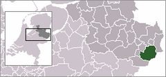
Enschede
 | |||||
| Państwo | |||||
|---|---|---|---|---|---|
| Prowincja | |||||
| Burmistrz | Onno van Veldhuizen (D66) | ||||
| Powierzchnia | 142,75 km² | ||||
| Populacja (2012) • liczba ludności • gęstość |
| ||||
| Nr kierunkowy | 053 | ||||
| Kod pocztowy | 7500-7549 | ||||
| Tablice rejestracyjne | E | ||||
 | |||||
| Strona internetowa | |||||
Enschede – miasto we wschodniej Holandii, w prowincji Overijssel, przy granicy z Niemcami. Około 163 tys. mieszkańców.
13 maja 2000 w mieście miał miejsce wybuch w fabryce fajerwerków, w którym zginęły 23 osoby.
W mieście znajduje się stacja kolejowa.
Enschede utrzymuje kontakty partnerskie z miastem Greifswald w Niemczech.
W mieście rozwinął się przemysł spożywczy oraz fotochemiczny[2].
Miasta partnerskie
Zobacz też
Przypisy
- ↑ World Gazetteer
- ↑ Enschede, [w:] Encyklopedia PWN [online] [dostęp 2021-06-26].
Media użyte na tej stronie
The flag of Navassa Island is simply the United States flag. It does not have a "local" flag or "unofficial" flag; it is an uninhabited island. The version with a profile view was based on Flags of the World and as a fictional design has no status warranting a place on any Wiki. It was made up by a random person with no connection to the island, it has never flown on the island, and it has never received any sort of recognition or validation by any authority. The person quoted on that page has no authority to bestow a flag, "unofficial" or otherwise, on the island.
Autor: Erik Frohne, Licencja: CC BY-SA 3.0
Location map of province Overijssel in the Netherlands
Equirectangular projection, N/S stretching 164 %. Geographic limits of the map:
- N: 52.90° N
- S: 52.00° N
- W: 5.70° E
- E: 7.10° E
Autor: Sekhar Lukose Kuriakose, Licencja: CC-BY-SA-3.0
International Institute of Geo-information Science and Earth Observation
Coat of arms of the Dutch municipality of Enschede.
Flag of the Dutch municipality of Enschede, Overijssel


