Enterprise (Alabama)
| City | |||
 Kolaż zdjęć przedstawiający miasto Enterprise | |||
| |||
| Dewiza: City of Progress | |||
| Państwo | |||
|---|---|---|---|
| Stan | |||
| Hrabstwo | Coffee, Dale | ||
| Data założenia | 1896 | ||
| Kod statystyczny | |||
| Powierzchnia | 80,3 km² | ||
| Wysokość | 109 m n.p.m. | ||
| Populacja (2020) • liczba ludności • gęstość |
| ||
| Nr kierunkowy | 334 | ||
| Kod pocztowy | 36330-36331 | ||
| Strefa czasowa | |||
| Strona internetowa | |||
| Portal | |||
Enterprise – miasto w Stanach Zjednoczonych, w stanie Alabama. Według spisu w 2020 roku liczy 28,7 tys. mieszkańców[1].
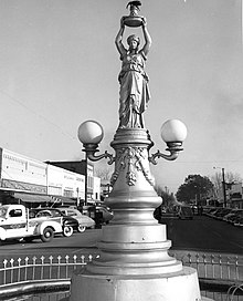
Enterprise słynie z dużego posągu mitologicznej postaci kobiecej z rozpostartymi ramionami, unoszącej dużą reprodukcję wołka bawełnianego. Pomnik ten upamiętnia pojawienie się tego szkodnika w 1915 roku, który zmusił mieszkańców do zmiany produkcji rolnej: wyspecjalizowali się wtedy w uprawie orzeszków ziemnych, a zmiana ta przyniosła miastu dobrobyt. Jest to jedyny znany na świecie przykład rzeźby gloryfikującej szkodliwego owada[2].
Przypisy
- ↑ U.S. Census Bureau QuickFacts: Enterprise city, Alabama, www.census.gov [dostęp 2022-11-19] (ang.).
- ↑ Smithsonian Magazine, Lorraine Boissoneault, Why an Alabama Town Has a Monument Honoring the Most Destructive Pest in American History, Smithsonian Magazine [dostęp 2022-11-19] (ang.).
Linki zewnętrzne
Media użyte na tej stronie
Autor: Uwe Dedering, Licencja: CC BY-SA 3.0
Location map of the USA (without Hawaii and Alaska).
EquiDistantConicProjection:
Central parallel:
* N: 37.0° N
Central meridian:
* E: 96.0° W
Standard parallels:
* 1: 32.0° N
* 2: 42.0° N
Made with Natural Earth. Free vector and raster map data @ naturalearthdata.com.
Formulas for x and y:
x = 50.0 + 124.03149777329222 * ((1.9694462586094064-({{{2}}}* pi / 180))
      * sin(0.6010514667026994 * ({{{3}}} + 96) * pi / 180))
y = 50.0 + 1.6155950752393982 * 124.03149777329222 * 0.02613325650382181
      - 1.6155950752393982  * 124.03149777329222 *
     (1.3236744353715044  - (1.9694462586094064-({{{2}}}* pi / 180))
      * cos(0.6010514667026994 * ({{{3}}} + 96) * pi / 180))
The flag of Navassa Island is simply the United States flag. It does not have a "local" flag or "unofficial" flag; it is an uninhabited island. The version with a profile view was based on Flags of the World and as a fictional design has no status warranting a place on any Wiki. It was made up by a random person with no connection to the island, it has never flown on the island, and it has never received any sort of recognition or validation by any authority. The person quoted on that page has no authority to bestow a flag, "unofficial" or otherwise, on the island.
Autor:
- praca pochodna, Enterprise Hospital.jpg, Coffee County AL, Courthouse.jpg, Enterprise Alabama Water Tower.jpg, Palm Tree Lined Road.jpg: Skuzbucket
- Boll weevil monument.jpg: United States Department of Agriculture
The head image for the Enterprise, Alabama Wikipedia page.
Autor: Alexrk2, Licencja: CC BY 3.0
Ta mapa została stworzona za pomocą GeoTools.
The Boll Weevil Monument in Enterprise, Alabama. "After the boll weevil destroyed (1910-15) the area's cotton, locals began diversified farming. In gratitude for the resulting prosperity, the city erected a monument to the boll weevil in 1919." [from The Columbia Encyclopedia, 3rd ed., s.v. Enterprise."] Series VII.1, Photographs, Box 7.1/3, file "II. Photographs--Boll Weevil Monument, Alabama," USDA History Collection, Special Collections, National Agricultural Library.
|
To jest zdjęcie miejsca lub budynku wpisanego na listę Narodowego Rejestru Miejsc Historycznych w Stanach Zjednoczonych pod numerem 73000336. |
Autor: Skuzbucket, Licencja: CC BY-SA 4.0
The flag of Enterprise, AL


