Esterholz
| obszar wolny administracyjnie | |
 | |
| Państwo | |
|---|---|
| Kraj związkowy | |
| Rejencja | Szwabia |
| Powiat | Donau-Ries |
| Powierzchnia | 3,23 km² |
| Populacja • liczba ludności | obszar niezamieszkany |
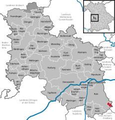
Położenie na mapie powiatu | |
| 48°38′N 11°01′E/48,633333 11,016667 | |
| Portal | |
Esterholz – obszar wolny administracyjnie (gemeindefreies Gebiet) w Niemczech w kraju związkowym Bawaria, w rejencji Szwabia, w regionie Augsburg, w powiecie Donau-Ries. Obszar jest niezamieszkany.
Bibliografia
- Bayerisches Landesamt für Statistik und Datenverarbeitung, Monachium
Media użyte na tej stronie
|
|
|
|
|
|
|
|
Autor: Rikiwiki2, Licencja: CC BY-SA 4.0
das Gebiet um die geologische Orgel im Esterholz ist während der Wuchsperiode nahezu unzugänglich, Geotop 779H004


