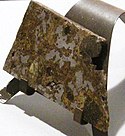
Estherville (meteoryt)
| ||
 Płytka meteorytu Estherville. | ||
| Sposób odkrycia | Spadły | |
| Państwo | ||
| Stan | ||
| Miejsce znalezienia | Estherville | |
| Data znalezienia | 10 maja 1879 | |
| Masa | 320 kg | |
| Typ | meteoryt żelazno-kamienny | |
| Klasa | mezosyderyt | |
Estherville – meteoryt kamienno-żelazny należący do mezosyderytów, spadły 10 maja 1879 roku o 17.00 czasu uniwersalnego w pobliżu miejscowości Estherville w stanie Iowa w USA.
Świadkiem upadku meteorytu był pasący krowy mały chłopiec. Opisał on upadek jako "istne gradobicie małych grudek żelaza, sypiących się do jeziorka". Meteoroid rozpadł się podczas przelotu przez ziemską atmosferę i spadł w postaci deszczu meteorytowego o elipsie rozrzutu długości 11 km. Ocenia się, że przed wejściem w atmosferę masa meteoroidu przekraczała 100 ton. Obecnie około 320 kg zebranej materii meteorytowej znajduje się w różnych większych kolekcjach świata. Największy znaleziony fragment ważył 198 kg. W meteorycie Estherville w 1980 roku zidentyfikowano nowy minerał: tetrataenit.
Bibliografia
- Meteoryt, biuletyn dla miłośników meteorytów, nr 1 (13), marzec 1995, str.8-11.
- Meteoritical Bulletin Entry for Estherville (ang.). The Meteoritical Society. International Society for Meteoritics and Planetary Science. [dostęp 2010-12-20].
Media użyte na tej stronie
Autor: Uwe Dedering, Licencja: CC BY-SA 3.0
Location map of the USA (without Hawaii and Alaska).
EquiDistantConicProjection:
Central parallel:
* N: 37.0° N
Central meridian:
* E: 96.0° W
Standard parallels:
* 1: 32.0° N
* 2: 42.0° N
Made with Natural Earth. Free vector and raster map data @ naturalearthdata.com.
Formulas for x and y:
x = 50.0 + 124.03149777329222 * ((1.9694462586094064-({{{2}}}* pi / 180))
      * sin(0.6010514667026994 * ({{{3}}} + 96) * pi / 180))
y = 50.0 + 1.6155950752393982 * 124.03149777329222 * 0.02613325650382181
      - 1.6155950752393982  * 124.03149777329222 *
     (1.3236744353715044  - (1.9694462586094064-({{{2}}}* pi / 180))
      * cos(0.6010514667026994 * ({{{3}}} + 96) * pi / 180))
The flag of Navassa Island is simply the United States flag. It does not have a "local" flag or "unofficial" flag; it is an uninhabited island. The version with a profile view was based on Flags of the World and as a fictional design has no status warranting a place on any Wiki. It was made up by a random person with no connection to the island, it has never flown on the island, and it has never received any sort of recognition or validation by any authority. The person quoted on that page has no authority to bestow a flag, "unofficial" or otherwise, on the island.
Shiny orange button/marker widget.
Autor: Alexrk2, Licencja: CC BY 3.0
Ta mapa została stworzona za pomocą GeoTools.


